AccuWeather meteorologists are available 24/7 to provide further insights and updates on evolving weather conditions. Please contact pr@accuweather.com during regular business hours, or support@accuweather.com or call AccuWeather’s Media Hotline at (814)-235-8710 at any time to arrange interviews with AccuWeather experts or to request the most updated graphics for print or broadcast.
Tropical Rainstorm takes aim at Gulf coast with risk of significant flooding
Sept. 7, 2024
> Impacts from second tropical rainstorm this month could trigger flash flooding
in parts of Texas and Louisiana through Friday

> The combination of heavy rain, gusty wind and saturated ground could lead to
downed trees, power outages and damage

> The next name on the list for the 2024 Atlantic hurricane season is Francine
AccuWeather Global Weather Center – Sept. 7, 2024
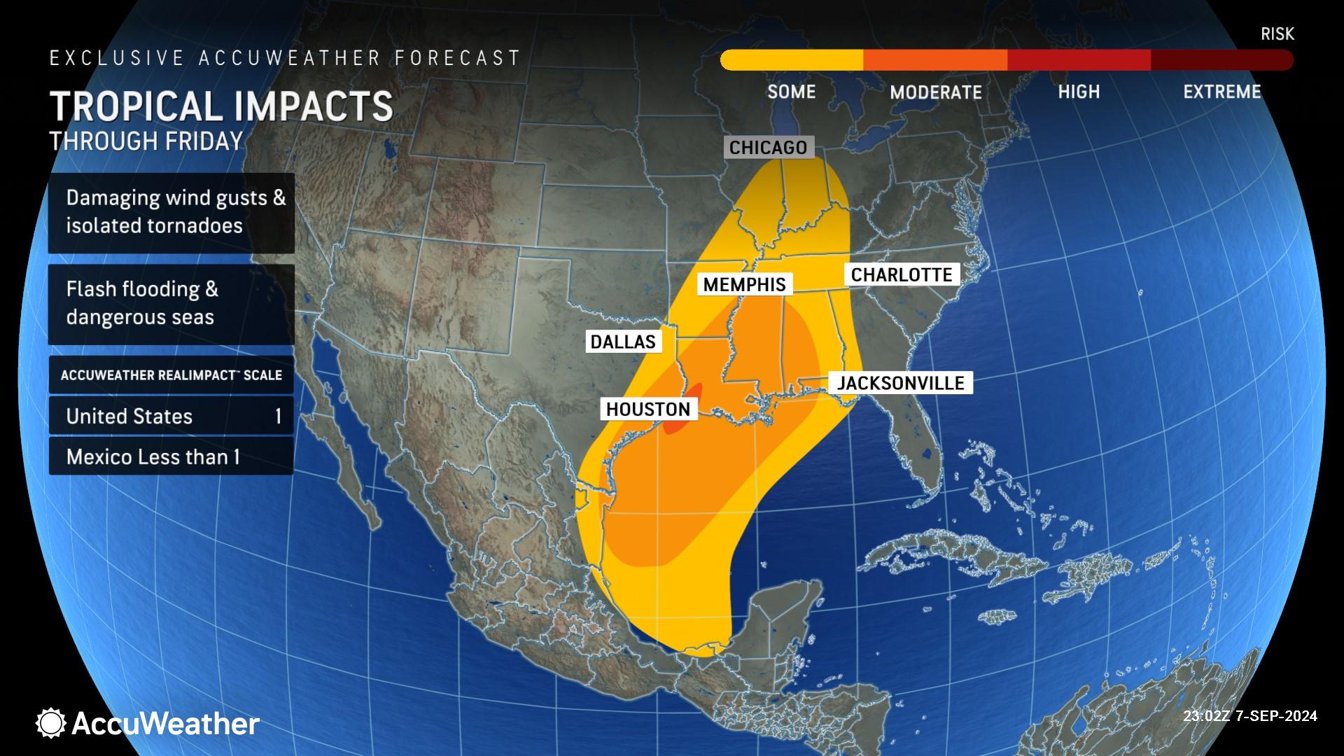
AccuWeather expert meteorologists say a tropical rainstorm that formed over the Bay of Campeche is expected to strengthen and bring flooding rainfall to the U.S. Gulf coast next week.
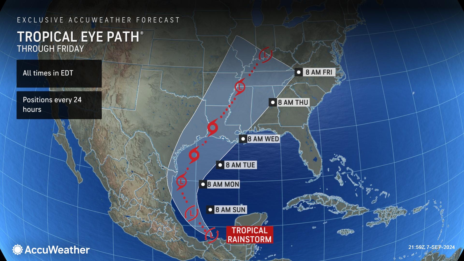
“While the Atlantic has remained eerily quiet for much of August into early September, it appears the tropics are heating up as a tropical rainstorm has developed over the Bay of Campeche,” said AccuWeather Meteorologist Isaac Longley. “With the rainstorm emerging off the coast of the Mexican state of Tabasco and entering the very warm waters of the Bay of Campeche, we expect this rainstorm to gain organization and wind intensity as we head through the rest of the weekend into the beginning of next week.”
An AccuWeather Forecast Eye Path® was first issued Saturday afternoon to alert families, businesses and leaders across the Gulf coast about the potential threat to public safety and property.
AccuWeather uses the term "tropical rainstorm" to refer to certain tropical systems that can bring significant impacts from rain and wind prior to official classification as a tropical depression or storm to raise public awareness of their disruptive, damaging and dangerous potential. Not all tropical rainstorms escalate to a depression or tropical storm.
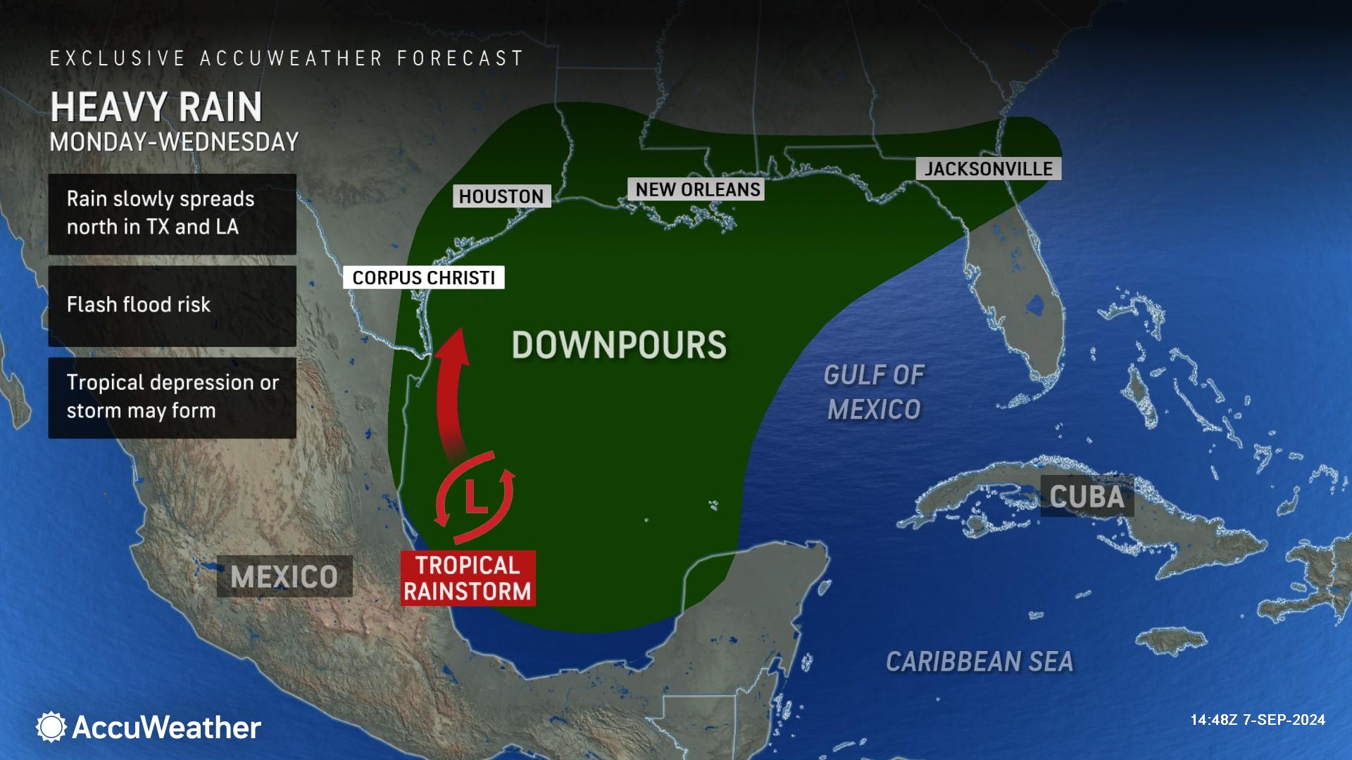
Longley said flooding is a major concern across coastal Texas and Louisiana next week.
“The tropical rainstorm is forecast to reach tropical storm strength by Tuesday evening as it continues on a northward track across the western Gulf of Mexico and is expected to move inland along the Texas-Louisiana border Wednesday night,” said Longley. “One of the main concerns with this storm is that it is forecast to move into an area already impacted by heavy rain and flooding from a separate tropical rainstorm this past week. The ground across far eastern Texas and into Louisiana is already saturated, so it would not take much rain to cause flooding across these areas.”
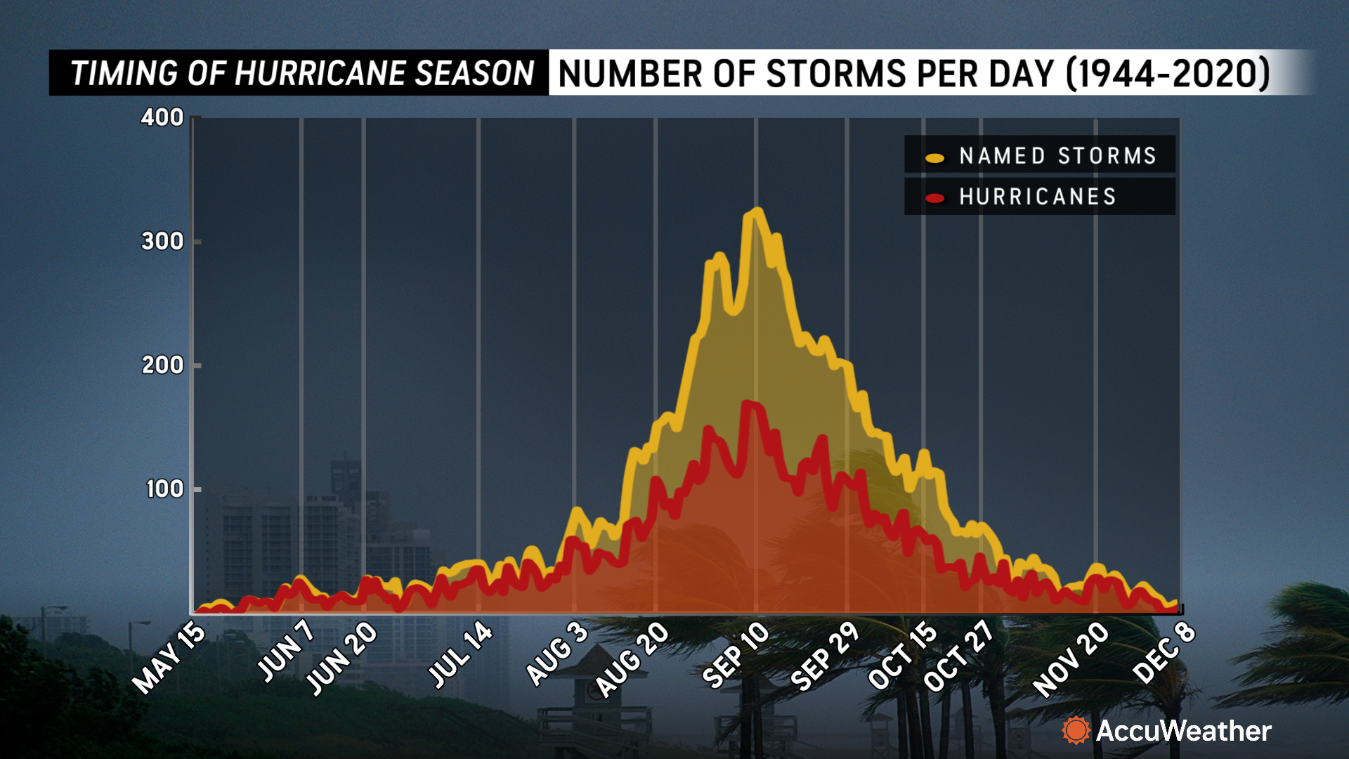
If the tropical rainstorm strengthens to have maximum sustained winds of at least 39 miles per hour, it will be named Francine. AccuWeather expert meteorologists say Sept. 10 is the climatological peak of the Atlantic hurricane season.
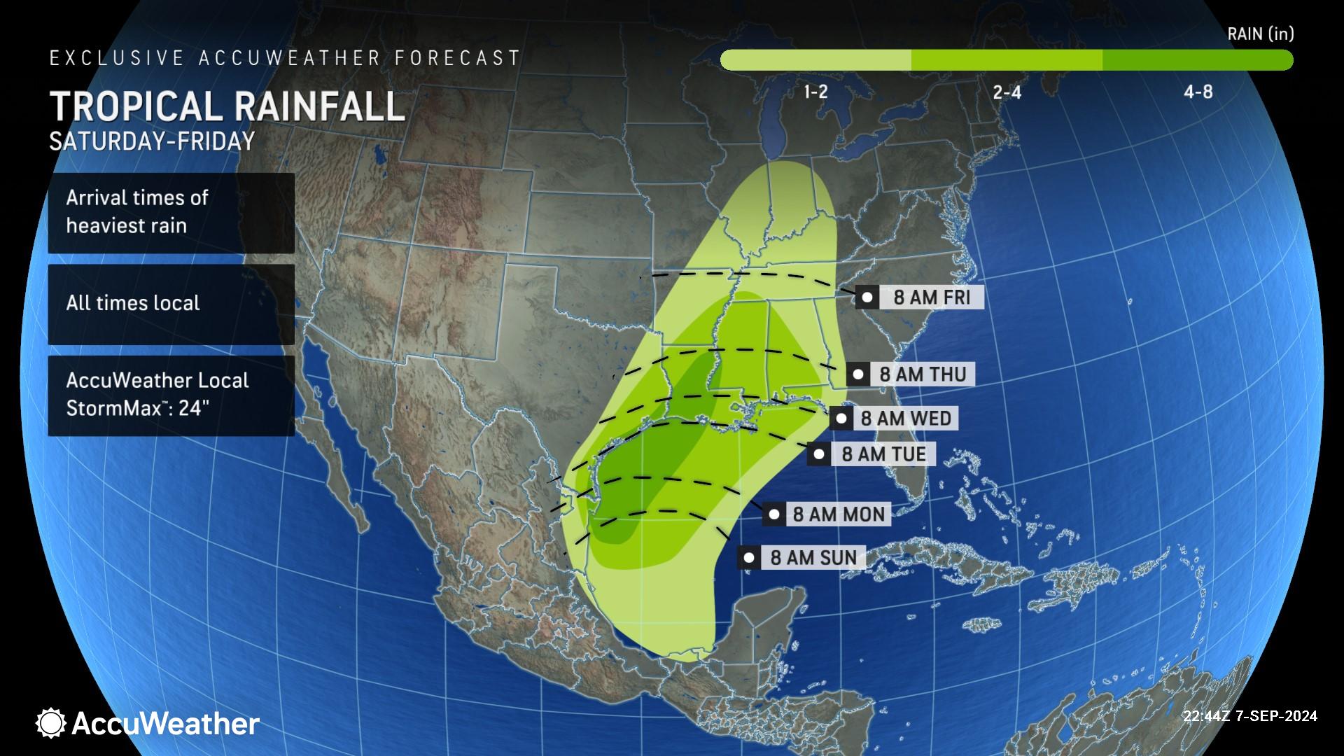
AccuWeather expert meteorologists are forecasting 4-8 inches of rain through Friday across parts of Texas and Louisiana. The AccuWeather Local StormMax™ is 24 inches.
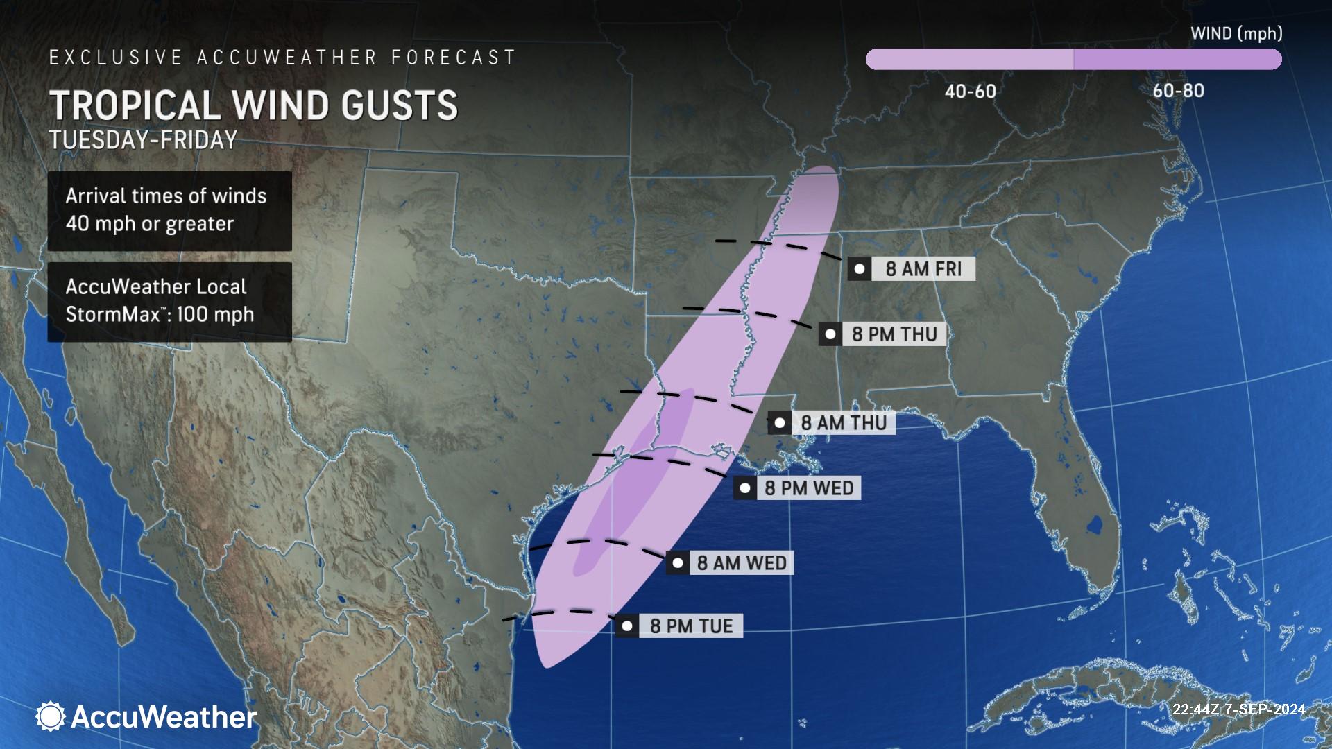
Along with the risk for flooding, Longley said people in the region should be prepared for the potential of damage, downed trees and power outages from powerful winds gusts.
“Rain will not be the only threat with this storm as strong, gusty winds are expected to spread inland as the storm pushes onshore. This can lead to some power outages as well as minor structural damage in areas near where the center of the storm moves ashore,” Longley explained. “While the wind impacts will subside as the storm loses wind intensity on its journey inland, heavy rain can still spread across the Lower Mississippi Valley late next week, leading to a continued threat for flooding.”
AccuWeather expert meteorologists say 60-80 mph wind gusts are possible along the Gulf coast through Thursday. The AccuWeather Local StormMax™ is 100 mph.
People along the Gulf coast should also be prepared for the threat of rough surf, dangerous rip currents and the potential for tornadoes that could quickly spin up in tropical rainbands.
This latest tropical threat is expected to bring a widespread 2-4 inches of rain across Louisiana, as well as parts of Arkansas, Mississippi, Alabama and Tennessee as it moves inland next week.
Much of the central United States needs drenching rain, as water levels on the middle and lower Mississippi River, and other rivers in the region, are at critically low levels. The Mississippi and Ohio rivers are used extensively to transport grains and other commodities cost-efficiently through tug and barge operations. Low water levels can hinder barge transportation, causing delays or forcing businesses to use more expensive delivery options.
The AccuWeather RealImpact™ Scale for Hurricanes in the U.S. is a 1, which warns of localized flooding, damage to unanchored mobile homes, localized power outages and coastal inundation resulting in property damage.
The AccuWeather RealImpact™ Scale for Hurricanes in Mexico is a less than 1, which warns of limited damage from wind and rain, as well as coastal inundation resulting in some property damage.
In contrast to the Saffir-Simpson Hurricane Wind Scale, which classifies storms by wind speed only, the AccuWeather RealImpact™ Scale is based on a broad range of important factors. In order to better communicate a more comprehensive representation of the potential impact of a storm on lives and livelihoods, the scale covers not only wind speed, but also flooding rain, storm surge and economic damage and loss. Some of these hazards, such as inland flooding and storm surge in many storms, result in more deaths and economic loss than wind.
More tropical trouble on the horizon?
AccuWeather expert meteorologists are closely monitoring tropical waves of low pressure moving westward from Africa. Rather than flourishing upon reaching warm waters and moisture from the Atlantic, these systems continue to struggle due to areas of dry air and wind shear.
The persistence of dry air and wind shear, along with warm air high up in the atmosphere, are keeping these potential tropical threats at bay. There's also a buzzsaw-like storm east of the Caribbean with wind shear that would likely rip apart any budding tropical wave as it approaches from the east next week.
Five reasons why the tropics have been unusually quiet
AccuWeather expert meteorologists say there are five key factors that are responsible for the longest streak without named storms in the Atlantic basin in more than 50 years.
The delayed arrival of La Niña, an abundance of dry and dusty air, a disruption in the African tropical wave train, cool waters off the coast of Africa and unusually high air temperatures high in the atmosphere are to blame for the lull in tropical activity in the Atlantic basin.
Warm air high above the ocean can cause the atmosphere to be more stable, which makes it more difficult for thunderstorms to develop and organize into a tropical depression or storm.
"Temperatures in the upper atmosphere in the tropics have been well above average this year and above 2023 levels,” said AccuWeather Lead Hurricane Expert Alex DaSilva. "This could be tied to climate change and a warmer planet.”
If the tropical rainstorm in the Gulf does not strengthen to a named tropical storm by Sept. 11, records show that this would become the longest streak without a named storm around the peak of hurricane season since at least the start of the satellite era in 1960.
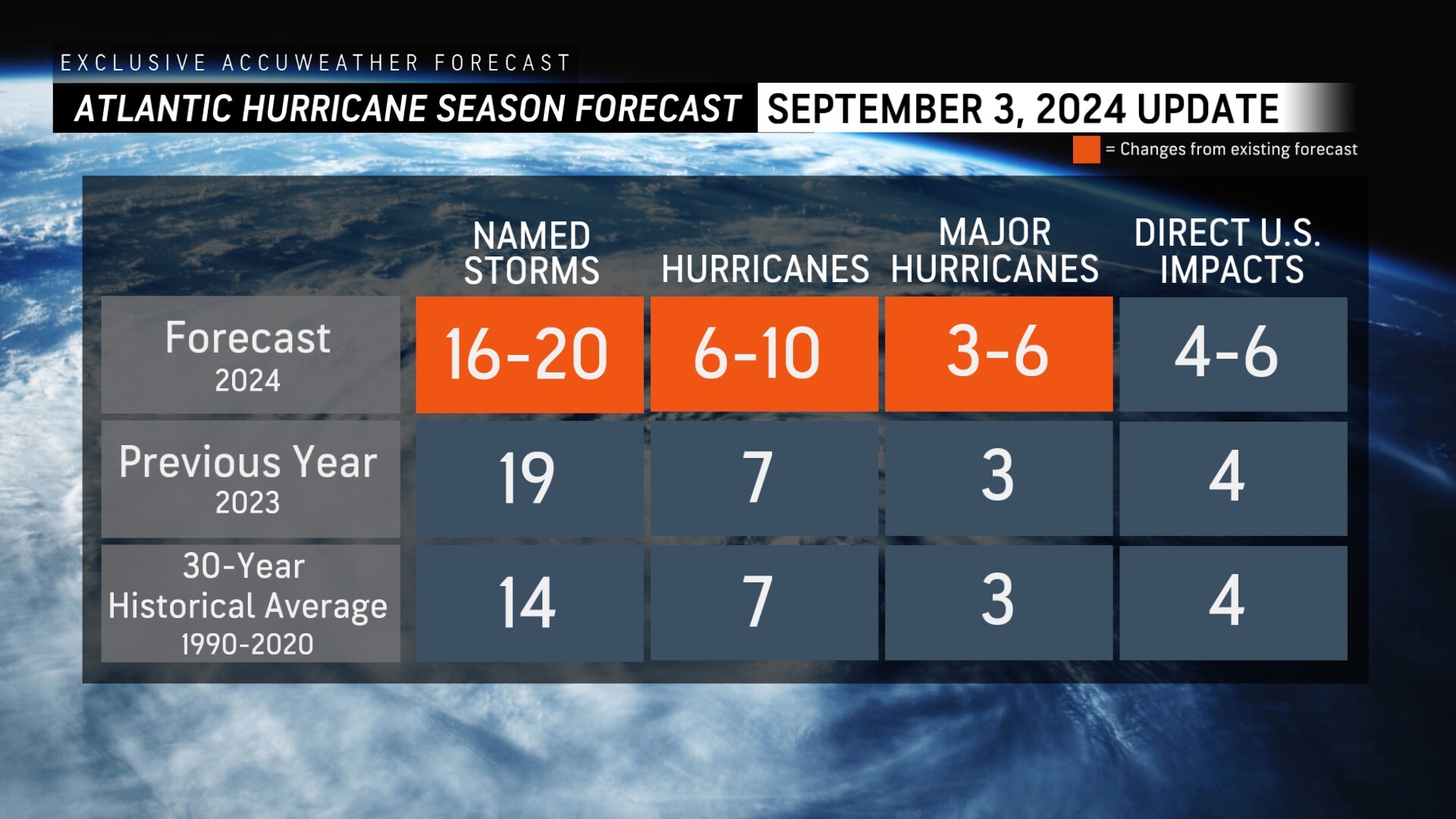
Following the first Labor Day holiday weekend without a named storm in decades, AccuWeather was the first known source to reduce the forecast for number of named storms, hurricanes and major hurricanes during the 2024 Atlantic Hurricane season.
AccuWeather is now forecasting;
> 16-20 named storms
> 6-10 hurricanes
> 3-6 major hurricanes
> 4-6 direct impacts to the United States
AccuWeather is the only source that has continually issued hurricane season forecast updates since AccuWeather’s first forecast was issued in March, ahead of other known sources.
AccuWeather Forecast Graphics
Additional AccuWeather Resources:
Hurricane Tracking & Storm Radar
Atlantic tropical development risk to focus on areas close to US into next week
5 reasons behind the historic absence of tropical storms this hurricane season
AccuWeather Reduces Forecast for Number of Named Storms and Hurricanes During 2024 Atlantic Hurricane Season
Rapidly Intensifying Hurricanes Near Coastline Pose Major Threat To US This Season


