AccuWeather meteorologists are available 24/7 to provide further insights and updates on evolving weather conditions. Please contact pr@accuweather.com during regular business hours, or support@accuweather.com or call AccuWeather’s Media Hotline at (814)-235-8710 at any time to arrange interviews with AccuWeather experts or to request the most updated graphics for print or broadcast.
Rapidly Intensifying Hurricanes Near Coastline Pose Major Threat To U.S. This Season
May 22, 2024
-
> Record sea-surface temperatures across the Atlantic Basin and La Niña
   conditions raising the risk of rapidly intensifying tropical storms and hurricanes

> Storms that strengthen quickly near the coast can leave people with less time to -
    prepare and evacuate

> Residents in coastal Texas, Florida Panhandle, South Florida, and Carolinas -
urged to prepare for heightened risk of direct impacts this hurricane season
AccuWeather Global Weather Center – May 22, 2024
With the Atlantic Hurricane Season beginning on June 1, AccuWeather expert meteorologists are concerned about a serious threat of rapidly intensifying storms during the 2024 Atlantic Hurricane season, which could leave families, businesses, and government leaders with less time to react and prepare.
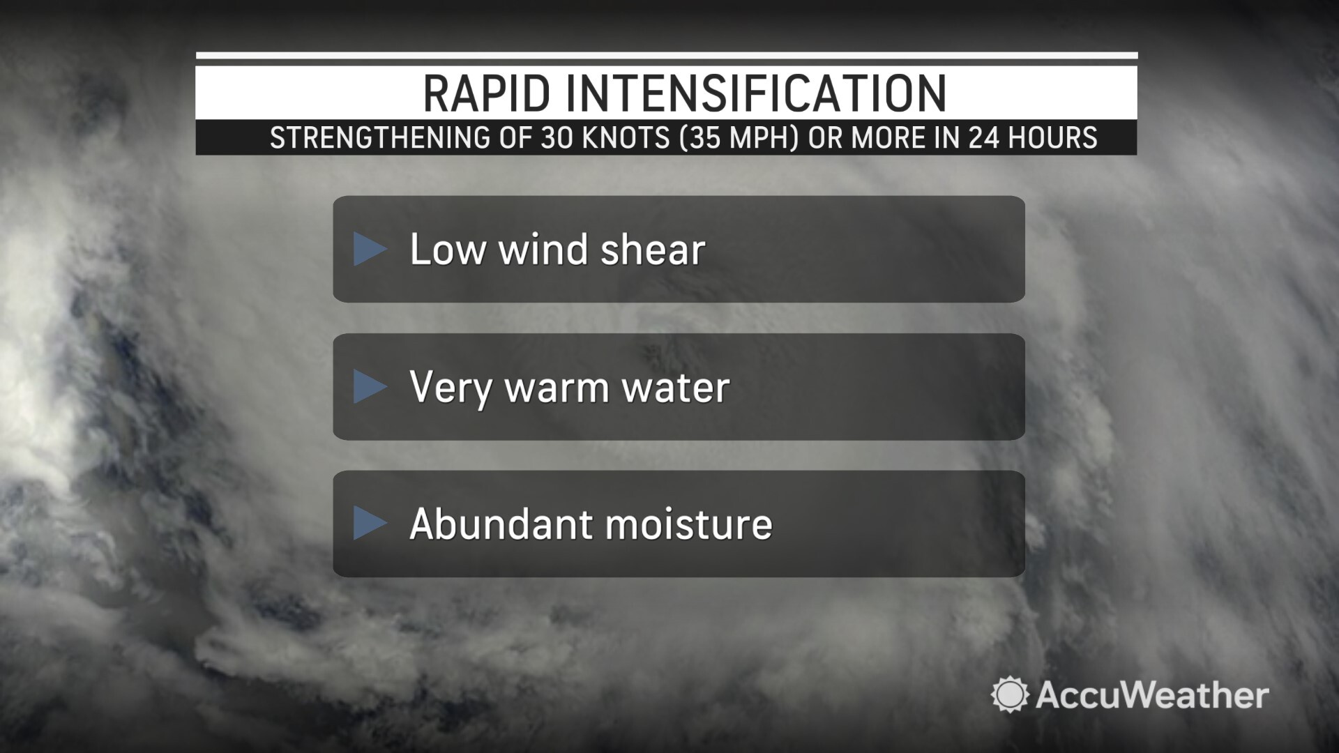
Rapid intensification of tropical storms and hurricanes is defined as a tropical storm or hurricane that quickly gains wind intensity of at least 35 mph in 24 hours or less.
AccuWeather Lead Hurricane Forecaster Alex DaSilva says rapidly intensifying tropical storms and hurricanes pose a major threat to life and property along the Atlantic and Gulf of Mexico coastlines.
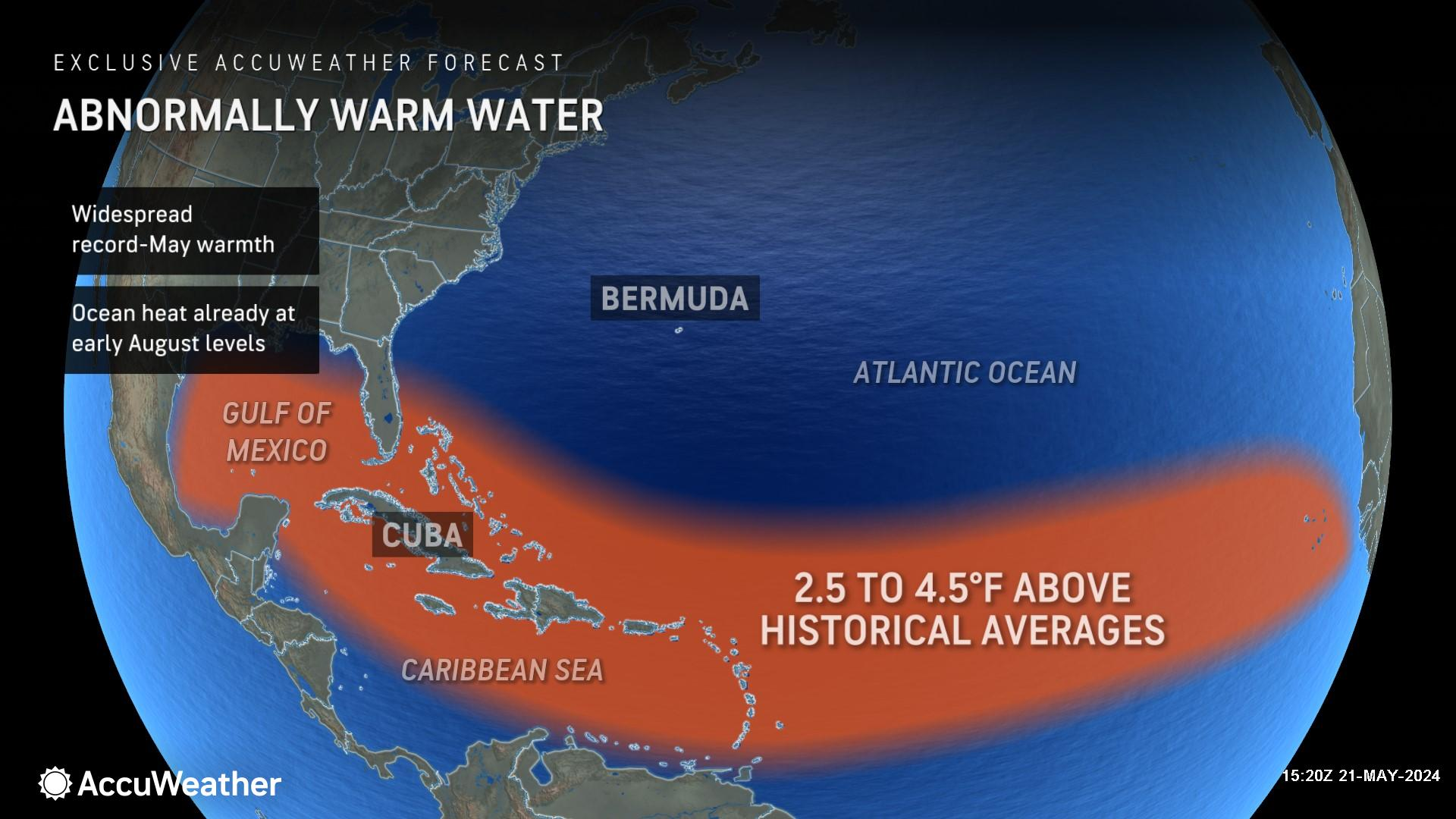
Many large coastal cities require 48 to 72 hours to announce mandatory evacuations, organize shuttles, and activate highway contraflow for evacuation traffic. State and local leaders are being urged to prepare for tropical threats that could quickly escalate into major storms this hurricane season.
Warmer Water & Less Wind Shear Ahead
The switch to a La Niña pattern, record-shattering warm ocean temperatures in the Main Development Region at the surface, and warm waters at deep depths are all red flags for AccuWeather expert meteorologists.
The minimum temperature threshold for tropical development is roughly 80 degrees Fahrenheit. AccuWeather expert meteorologists say many areas of the Caribbean, Gulf of Mexico, and southwest Atlantic basin are already above that threshold.
“Sea-surface temperatures across the Atlantic Basin as a whole have never been warmer in recorded history on this date than they are right now. The fear is that as we enter the heart of the tropical season, the sea-surface temperature may eclipse the record-breaking season that was 2023,” said DaSilva. “2023 is the benchmark for the warmest that the Atlantic basin has ever been in recorded history. Tropical storms and hurricanes love to feed off of warm ocean water. The warmer the oceans are, the more favorable the environment will be for tropical development and intensification.”
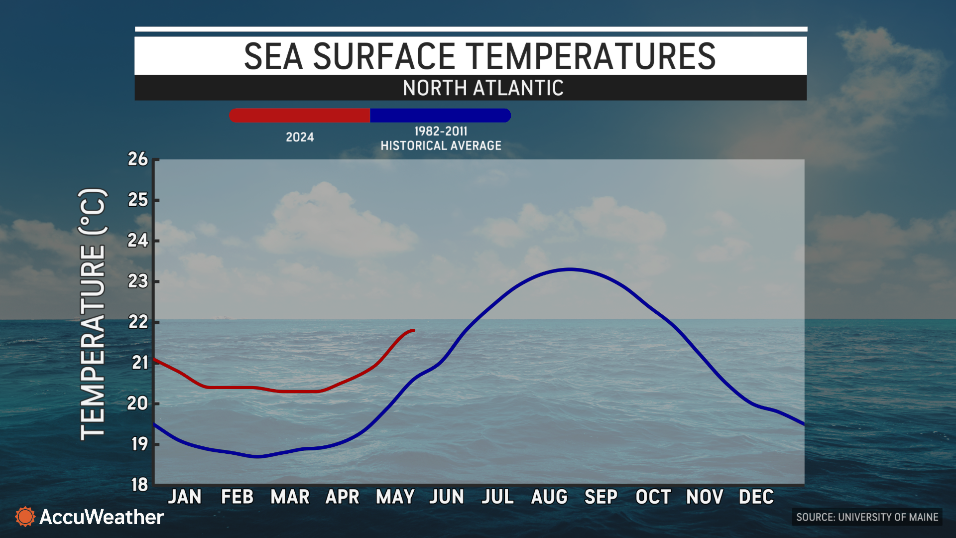
Ocean waters in the Main Development Regional typically continue to warm through August and into early September.
DaSilva says the La Niña weather pattern usually leads to less disruptive wind shear in the Atlantic basin, which can create ideal conditions for storms to rapidly intensify.
Warmer Water & Less Wind Shear Ahead
AccuWeather expert meteorologists say the Ocean Heat Content, or depth of warm ocean waters, right now across the Gulf of Mexico, the south-central Atlantic, the Caribbean, and waters off the southeast U.S. coast are in territory that is typically seen in August.
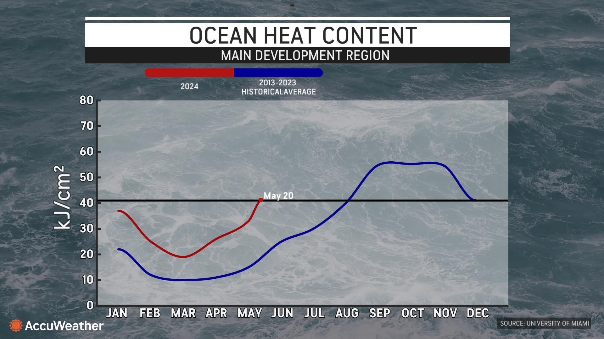
“There is a patch in the Caribbean, near Jamacia, where 80-degree water reaches a depth of 600 feet,” said DaSilva.
As tropical storms and hurricanes pass over warm surface waters, the wave action produced by strong winds blowing on the ocean creates massive waves and upwelling, where water from the depths mixes with the surface. Most of the time, this will lead to the colder deep water cooling the surface water and then cause the intensity of a slow-moving hurricane to level off or weaken. When a hurricane moves quickly, this cool upwelling action is reduced as the storm will continue to encounter warm surface water. The deeper the warm waters reach, the less impact upwelling will have.
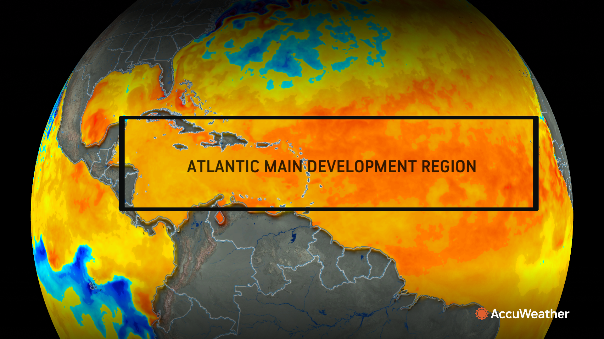
“This extent of warm surface water and high Ocean Heat Content is of great concerns for the 2024 season, as high Ocean Heat Content is like rocket fuel for tropical cyclones,” said DaSilva.
History Of Rapidly Intensifying Storms
Hurricane Ian is one example of a storm that moved over a high area of Ocean Heat Content and intensified rapidly. Ian underwent multiple rapidly strengthening phases in 2022, but the most significant one occurred shortly after the hurricane moved north of the coast of Cuba on Sept. 27.
The following day, Hurricane Ian went from a 120-mph Category 3 hurricane to a 160-mph Category 5 hurricane in less than 24 hours, before striking the southwestern Florida coast as a Category 4 at landfall . The total number of lives lost is estimated at 161, with additional people reported missing. Damage from Ian reached $113 billion, making it the costliest hurricane in Florida history.
Another striking example of rapid intensification is Eastern Pacific Hurricane Otis in 2023. Otis underwent tremendous strengthening from a Category 1 (74-95 mph) hurricane at 7 a.m. CDT on Oct. 24 to a Category 5, 165-mph hurricane a mere 15 hours later at 10 p.m.
Otis struck just west of Acapulco, Mexico as a Category 5 storm during the early-morning hours of Oct. 25. At least 50 people lost their lives in the storm. Damage estimates range from $12-16 billion, making it the costliest Eastern Pacific Hurricane and the costliest in Mexico's history.
“Over the last couple of years, there have been many examples where this has been exceeded. We’ve seen 40 mph, 50 mph, even 60 mph increases in a 24 hour period,” said DaSilva. “My greatest fear this season is rapid intensification. It can go from a strong tropical storm to a Category 4 or Category 5 hurricane in a very short period of time.”
Shrinking Window Of Time To React
Extreme winds and storm surge inundation are the biggest concerns for rapidly intensifying tropical storms and hurricanes, which could impact last-minute emergency planning and evacuation routes.
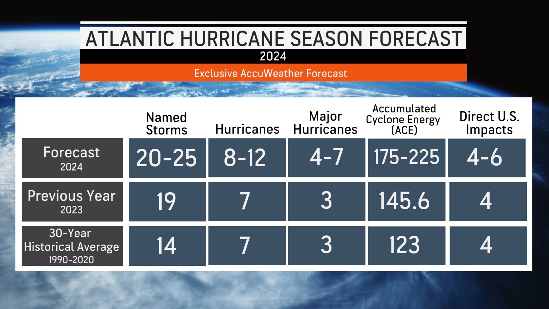
The AccuWeather 2024 U.S. Hurricane Forecast was issued in March to provide advanced notice to help families, businesses and leaders prepare. AccuWeather’s exclusive forecast calls for 20 to 25 named storms, 4-7 of which will strengthen to major hurricanes. AccuWeather’s forecast calls for 4-6 direct U.S. impacts.
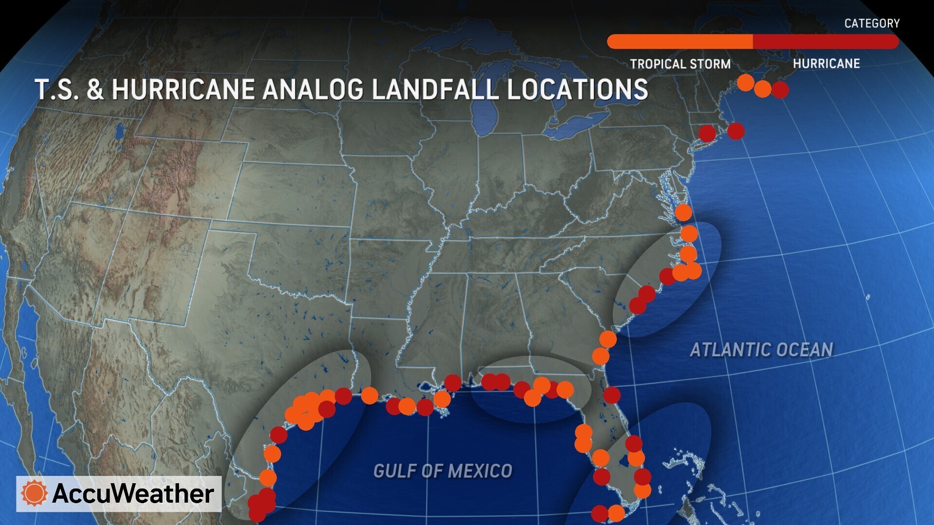
“This year we’re exceptionally concerned about the Texas coast, Florida Panhandle, South Florida, and the Carolinas,” warned DaSilva. “Storm surge and rainfall flooding are the deadliest threats from a hurricane. More people die from storm surge and flooding than the wind.”
AccuWeather Senior Meteorologist Dave Houk, who is a long-time Florida resident, is urging people to prepare for tropical threats that could leave them with less time to react and evacuate.
"Proper planning and preparation prevent panic when a hurricane suddenly forms nearby or undergoes rapid strengthening," said Houk. "If ordered to evacuate, is the emergency kit prepared properly? Based on the forecast track of the storm, should evacuation to an area to the north, south, east or west be best for minimal impacts?"
Houk stresses that people need to be aware of their surroundings, such as whether they are near the coast, a bay or a river, where storm surge can lead to rapidly rising water in their location and impact their escape route. An elevation a couple dozen feet above sea level may be much safer than one only a few feet above sea level.
For those who choose to ride out the storm instead of evacuating, there may be the risk of flying debris or falling trees that can destroy homes, in addition to the potential for life-threatening, rapidly rising water in the immediate neighborhood, People should be prepared for great hardship without electricity and fresh public water for days after a hurricane strikes. Downed electric lines, displaced wild animals, and contaminants in flood waters are additional safety concerns.
AccuWeather expert meteorologists urge people to stay connected and prepare for an active hurricane season. The AccuWeather RealImpact Scale for Hurricanes considers many consequences a tropical system may have in addition to winds, such as coastal inundation, freshwater flooding, topography, and the population affected. The Saffir-Simpson Hurricane Wind Scale accounts for a storm's wind intensity only.
“The situation can quickly evolve with rapidly intensifying storms and that can impact your evacuation decisions,” said DaSilva. “You don’t want to be scrambling last minute to get supplies and evacuate your family. Make sure you are prepared by the official start of hurricane season on June 1.”
Additional AccuWeather Resources:


