AccuWeather meteorologists are available 24/7 to provide further insights and updates on evolving weather conditions. Please contact pr@accuweather.com during regular business hours, or support@accuweather.com or call AccuWeather’s Media Hotline at (814)-235-8710 at any time to arrange interviews with AccuWeather experts or to request the most updated graphics for print or broadcast.
Urgent plea for evacuations in Tampa Bay region southward to Fort Myers ahead of catastrophic storm surge from Hurricane Milton
Oct. 8, 2024
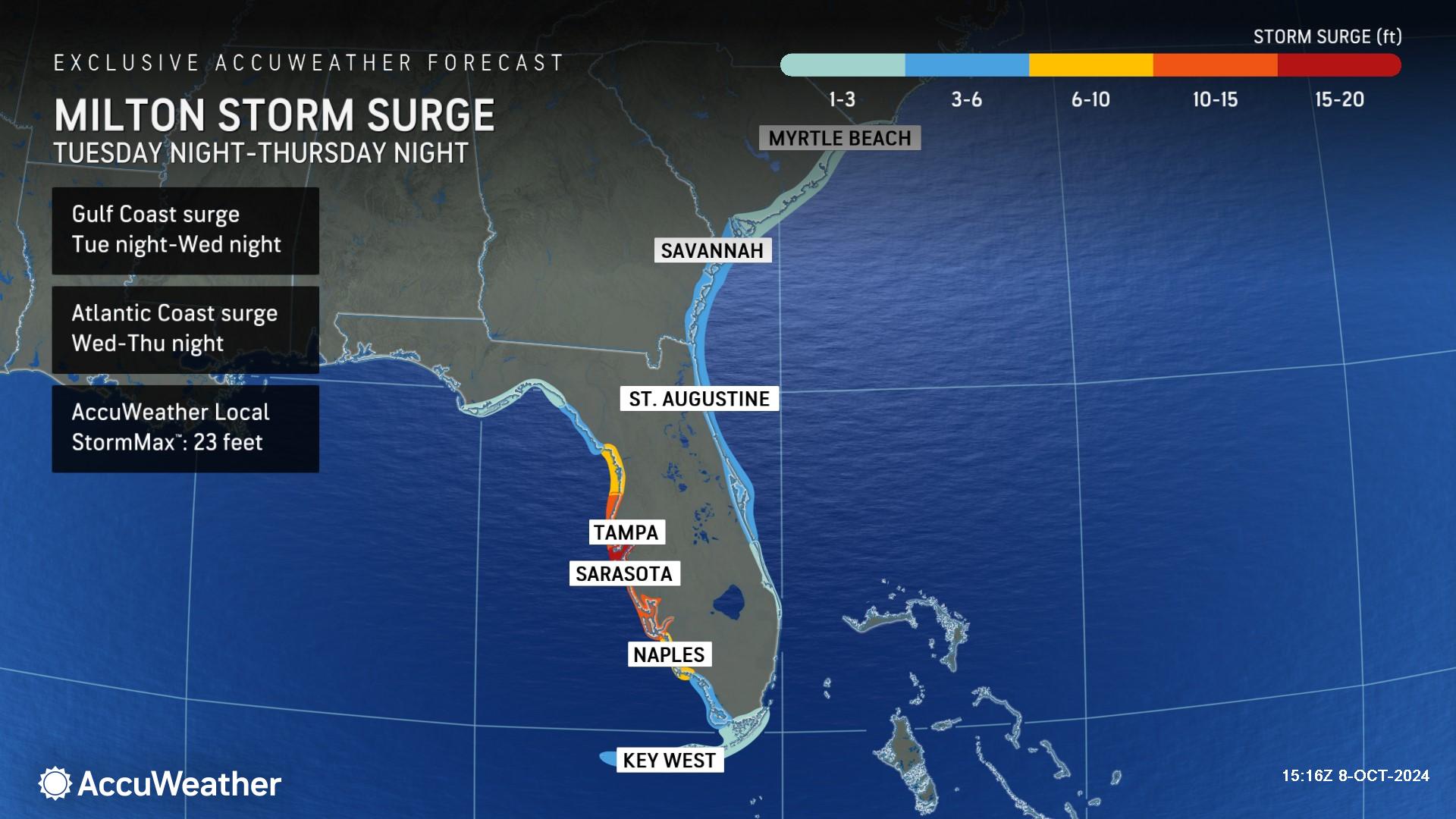
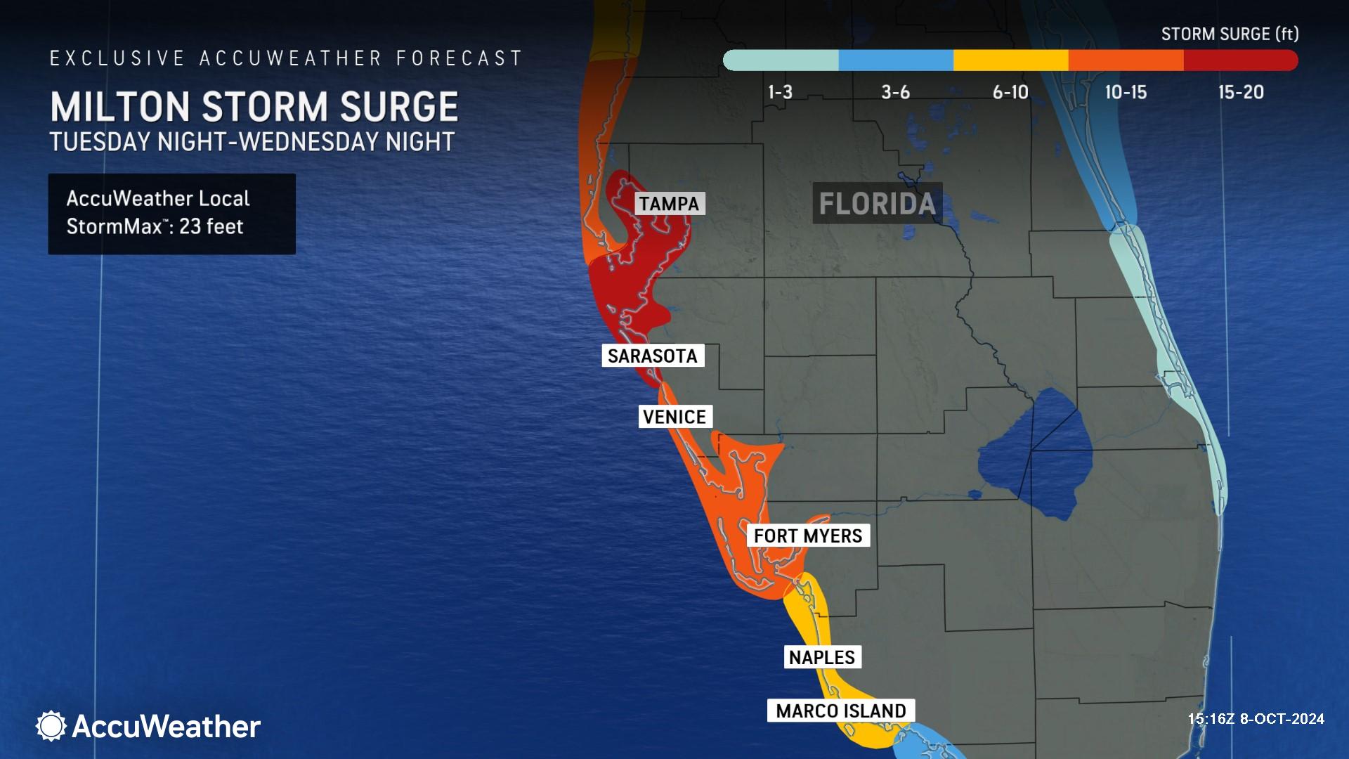
> AccuWeather Local StormMax™ of 23 feet of life-threatening storm surge potential in the Tampa Bay and Sarasota regions
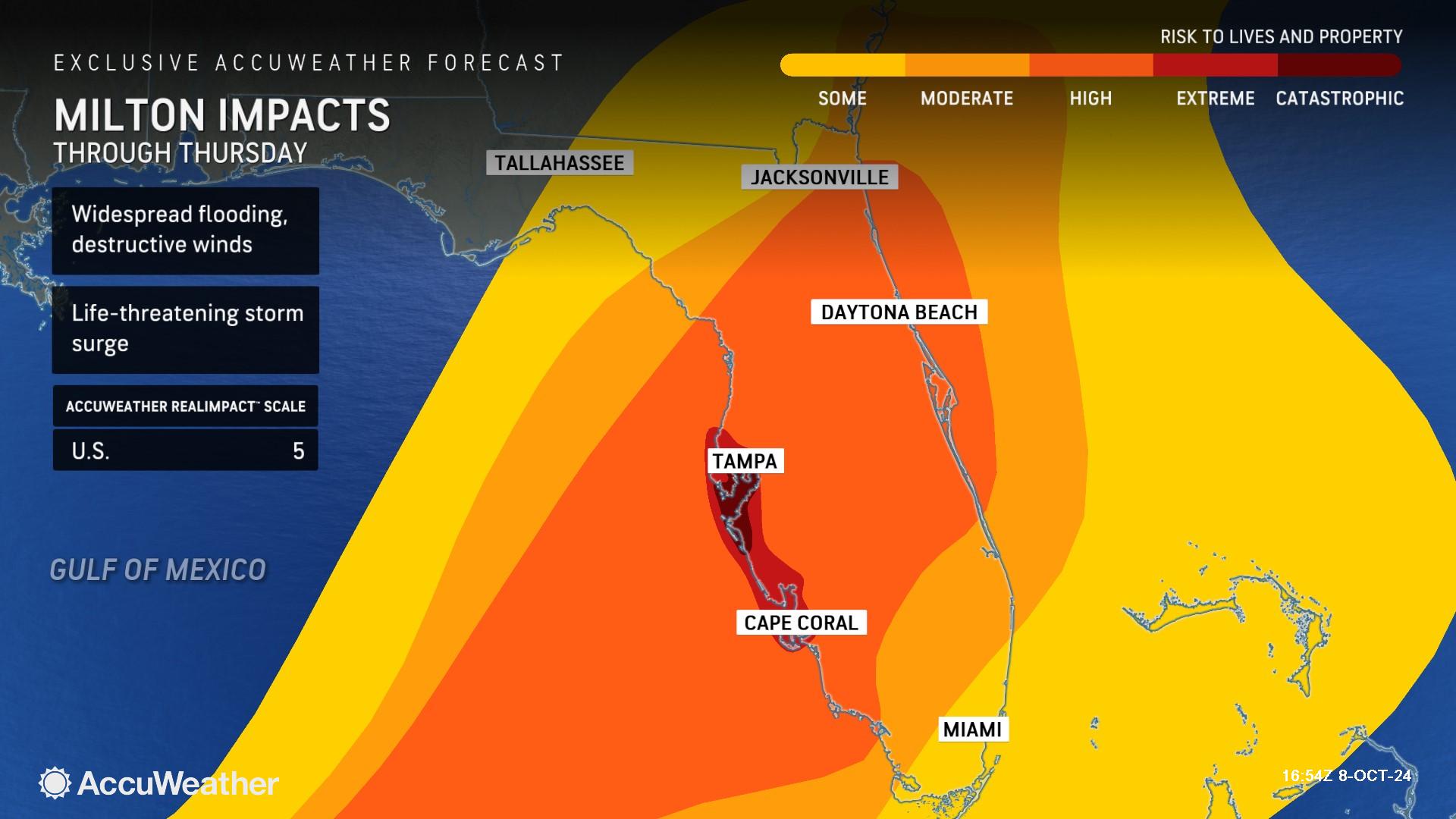
> Hurricane Milton is now rated a 5 on the AccuWeather RealImpact™ Scale for hurricanes. The last time a 5 on the AccuWeather RealImpact™ Scale for hurricanes was issued was ahead of Hurricane Ian’s destructive landfall near Fort Myers Beach, Florida, in 2022.
>>> WATCH TUESDAY’S MEDIA BRIEFING WITH ACCUWEATHER LEAD HURRICANE EXPERT ALEX DASILVA
Passcode: zreu.S5D
AccuWeather Global Weather Center – Oct. 8, 2024
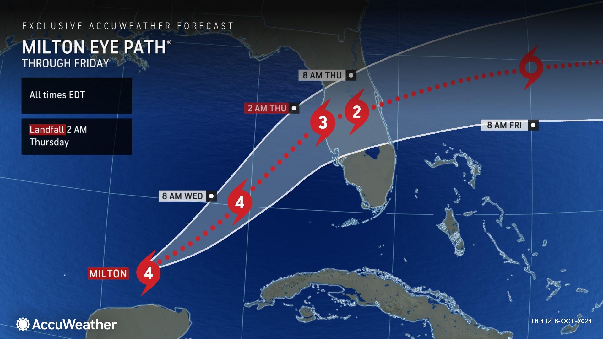
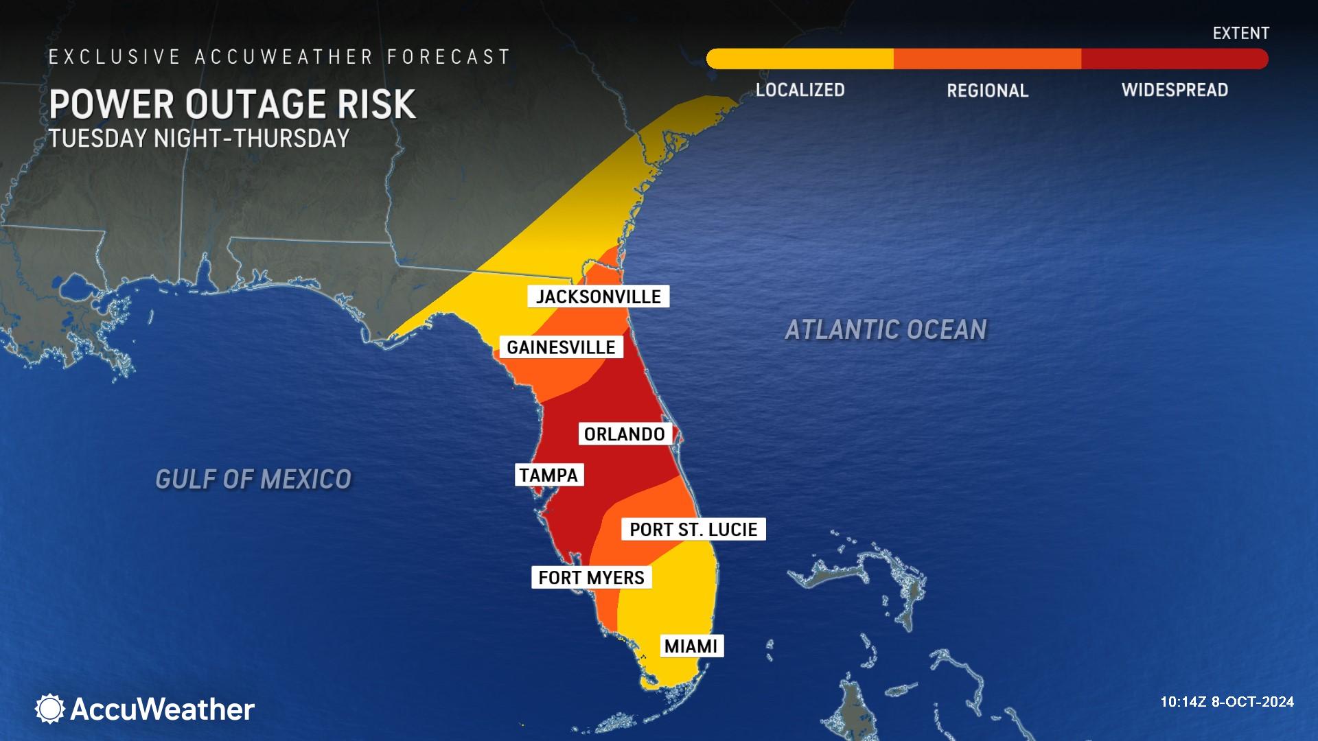
"Milton is expected to bring catastrophic damage to Florida from potentially record storm surges along the Gulf Coast in the Tampa Bay region and areas to the south, including Fort Myers,” said AccuWeather Chief Meteorologist Jon Porter. “Milton will bring hurricane conditions across the heavily populated I-4 corridor, including Orlando, with damaging winds, flooding rains and long-term power outages. In addition, piles of debris left on the curbs from the storm surge and flooding damage from Hurricane Helene just two weeks ago will likely be swept away by the storm surge and pushed into buildings. Debris left behind after Helene could also turn into deadly airborne missiles when Hurricane Milton reaches the Gulf Coast with destructive wind gusts. AccuWeather experts estimate that Milton could produce more than $200 billion in total damage and economic loss, especially if the hurricane makes landfall in or just north of the mouth of Tampa Bay. We’re facing the threat of two weather disasters in the span of two weeks in the United States, each causing more than $200 billion in total damage and economic loss.”
On Tuesday afternoon, AccuWeather expert meteorologists increased Hurricane Milton to a 5 on the AccuWeather RealImpact™ Scale for Hurricanes in the United States.
In contrast to the Saffir-Simpson Hurricane Wind Scale, which classifies storms by wind speed only, the AccuWeather RealImpact™ Scale is based on a broad range of important factors. In order to better communicate a more comprehensive representation of the potential impact of a storm to lives and livelihoods, the scale covers not only wind speed, but also flooding rain, storm surge and economic damage and loss. Some of these hazards such as inland flooding and storm surge in many storms result in more deaths and economic loss than wind.
A 5 on the AccuWeather RealImpact™ Scale for Hurricanes warns of widespread catastrophic flooding in major population centers. Flooding may last days to weeks. structural damage to buildings, power outages and trees down, as well as catastrophic inundation in populated areas will be widespread. Coastlines altered by the hurricane may take years or longer to recover.
The last time AccuWeather expert meteorologists issued a 5 on the AccuWeather RealImpact™ Scale for hurricanes was ahead of Hurricane Ian’s catastrophic landfall in the Fort Myers Beach area of Florida in 2022.
"Even if Milton loses wind intensity and makes landfall as a Category 3 storm, the storm surge will still be life-threatening, and in some places, it will likely be catastrophic. Both Katrina and Rita, two storms in 2005 in other parts of the Gulf Coast, share this similarity. In each case, they intensified into a Category 5 storm before making landfall as a Category 3. Katrina’s maximum storm surge of 26-28 feet devastated Mississippi and is the record in the Atlantic basin, while also causing the catastrophe in New Orleans when the levees failed. In Rita’s case, the surge reached 15 feet along the Louisiana coast and extended several miles inland, completely devastating many towns,” said AccuWeather Director of Forecasting Operations Dan DePodwin. “There is no recent precedent for a major hurricane to take this path toward Florida. Previous storms, including Helene and Ian, are likely not representative of the potential impacts to the Tampa area, including Sarasota, Bradenton, St. Petersburg and Clearwater. This is an increasing significant risk of devastating, catastrophic impacts to this region."
Storm surges of 15-20 feet may occur in and near Tampa Bay, with an AccuWeather Local StormMax™ of 23 feet.
Some areas along the Gulf coast of Florida are at an increased vulnerability to storm surge due to the absence of protective sand dunes and barriers from damage sustained from Helene. This will create an extremely dangerous situation for coastal areas that will once again have dangerous and life-threatening surges.
“Should Milton track a bit farther south and make landfall south of Tampa, the storm surge in Tampa Bay can remain dangerous but not as extreme. Such a track would also greatly increase the risk for significant, damaging water inundation in areas that experienced widespread destruction from Hurricane Ian’s storm surge, especially areas near Fort Myers, Naples and Charlotte Harbor. Even with Milton moving up toward Tampa, there will still be life-threatening surge in the Fort Myers area."
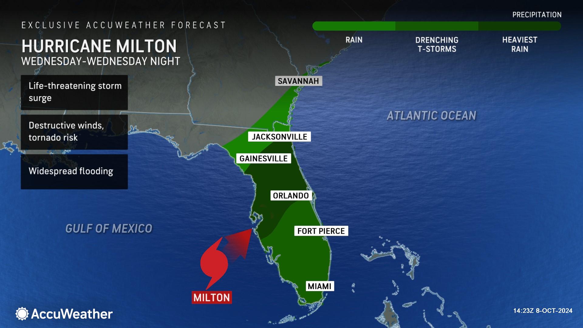
Milton will approach the west coast of Florida Tuesday night into Wednesday then cross the Florida Peninsula Wednesday evening before moving out over the open waters of the Atlantic Ocean by Thursday.
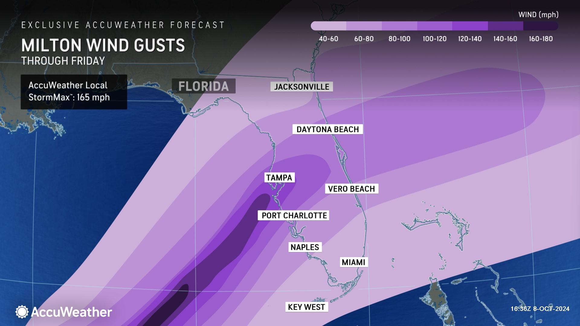
Destructive wind gusts are expected as Hurricane Milton moves inland and across the Florida Peninsula. Wind gusts of 60-80 mph can occur across much of the central and southern Florida Peninsula. Near where the center of circulation makes landfall, wind gusts can reach 120-140 mph with an AccuWeather Local StormMax™ of 165 mph. As the storm moves across, areas along the populous I-4 corridor can experience hurricane conditions, with flooding rain, damaging winds and even localized tornadoes.
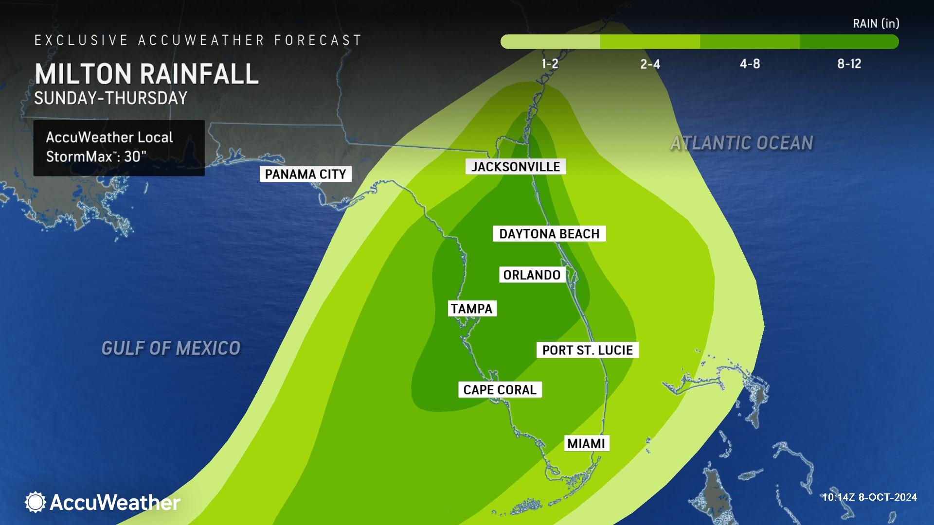
As the storm approaches the eastern Gulf Coast, a wide swath of 2-4 inches of rain will fall across parts of the Florida Peninsula, southeastern Georgia and the northern Bahamas. Rainfall totals of 4-8 inches can extend into much of the Florida Peninsula. Across central and northeastern parts of the Florida Peninsula, rainfall totals can reach 8-12 inches with an AccuWeather Local StormMax™ of 30 inches.
This heavy rainfall can lead to widespread flooding, impassable roads and standing water for days, causing major transportation disruptions. There is the potential for areas of repeated downpours posing a risk for extreme flooding over a period of multiple days. Rainfall rates can reach 2-4 inches per hour with the heaviest downpours. If this occurs in urbanized areas, it can result in catastrophic flooding, including roads becoming impassable for a time.
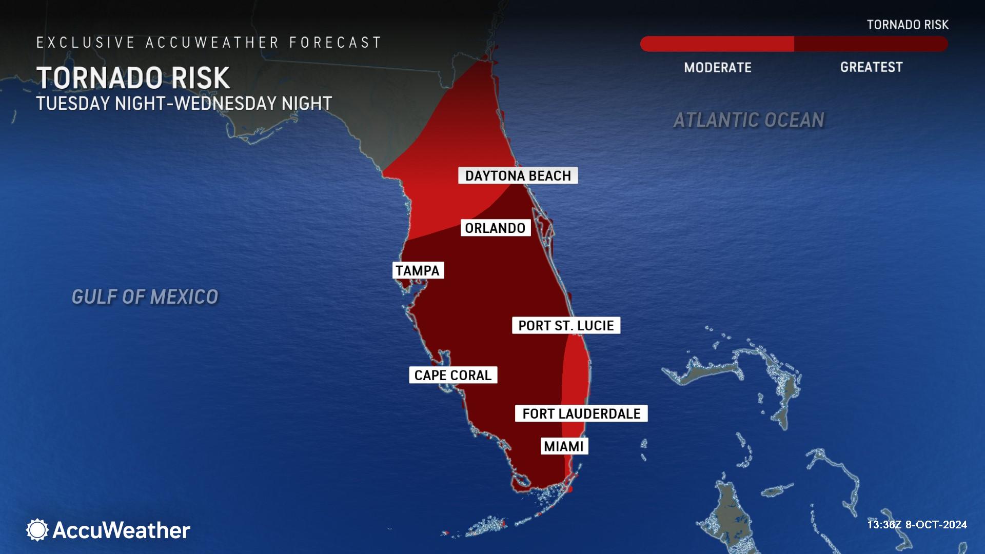
AccuWeather expert meteorologists say tornadoes will be possible to the northeast, east and southeast of the path of Milton Tuesday night through Wednesday night.
AccuWeather Climate Expert and Senior Meteorologist Brett Anderson says our warming atmosphere and higher ocean temperatures are amplifying the risks and hurricane impacts in the United States this year.
“The ongoing marine heat wave in the Gulf of Mexico has resulted in record high sea surface temperatures and record high ocean heat content, which is a measure of the amount of heat stored in the Gulf as far down as 2,000 meters. This has the fingerprints of climate change written all over it,” Anderson explained. “This extreme amount of heat stored in the Gulf is adding a tremendous amount of excess energy to these hurricanes in the form of added wind energy and moisture, leading to rapid intensification and excessive rainfall rates. Warm water is the main energy source for hurricanes. The warmer the water, the more available energy. The higher the air temperature, the more moisture it can hold, that is why we are so concerned about the impacts that global warming is having on hurricanes and other extreme weather events.”
Anderson says Hurricane Helene shattered records less than two weeks ago, and Hurricane Milton could do the same over the next 48 hours.
“There is data that shows that the amount of available atmospheric moisture, or precipitable water, from Helene was the highest on record. This surge of extreme moisture was able to be directed far inland, all the way up into the southern Appalachians and the Ohio Valley. This led to a sustained period of very intense rainfall and an extremely rapid rise of rivers and streams that caught many people off guard, especially in areas that hardly ever encounter significant flash flooding. Unfortunately, Milton will be tapping into the same moisture source as Helene as it turns northeastward toward Florida. We may see yet another new record for atmospheric moisture,” Anderson said. “There was a band of heavy rainfall that set up across the southern Appalachians well in advance of Hurricane Helene There are also bands of heavy rainfall ahead of Milton but much farther south across the Florida Peninsula, which is bad news for Florida. Fortunately, for the hard-hit areas of Georgia, South Carolina, North Carolina and Tennessee, Milton is expected to turn more eastward late this week and is not expected to bring rain or wind impacts to the southern Appalachians. During Helene, there was also a second storm diving south into the lower Mississippi Valley which added even more energy to Helene as the storms merged. That led to more wind and rain for a longer period of time, well after Helene made landfall.”
AccuWeather Forecast Graphics
Additional AccuWeather Resources:
Central Florida braces for life-threatening impacts from Hurricane Milton landfall as a major hurricane
LIVE: Milton forces over 1 million to evacuate in Florida, gas shortages reported
Helene’s survivors shoulder catastrophic loss and destruction after storm leaves at least 213 dead
Helene is 2nd-deadliest U.S. hurricane in 50 years, could cost $250 billion
Hurricane Tracking & Storm Radar


