


AccuWeather meteorologists are available 24/7 to provide further insights and updates on evolving weather conditions. Please contact pr@accuweather.com during regular business hours, or support@accuweather.com or call AccuWeather’s Media Hotline at (814)-235-8710 at any time to arrange interviews with AccuWeather experts or to request the most updated graphics for print or broadcast.
Dry conditions in the Northeast & Mid-Atlantic will impact fall foliage and increase the risk of fires
Oct. 17, 2024

AccuWeather Global Weather Center – Oct. 17, 2024
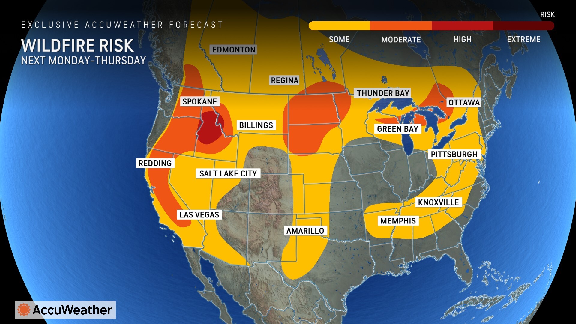
“A strong area of high pressure will bring continued dry conditions to a large portion of the East. Areas that have been dry will face an increased risk of brush fires and wildfires, especially the mid-Atlantic, parts of the Tennessee Valley, and parts of the Southeast inland from the Gulf of Mexico,” said AccuWeather Lead Long-Range Expert Paul Pastelok. “We highly discourage open burning in these areas. Fires can quickly spread out of control in these dry conditions.”
AccuWeather’s team of Long-Range Experts have expanded the area at risk of wildfires in the interior Northeast and parts of the mid-Atlantic starting next Monday through Thursday.
“The fall season can be one of the most active times of year for wildfires in the Northeast and mid-Atlantic. Without tropical systems, dry stretches are common and gusty winds become more common as autumn progresses,” explained AccuWeather Senior Director of Forecasting Operations Dan DePodwin. “The combination of these conditions, along with low relative humidity, make wildfire spread more likely.”
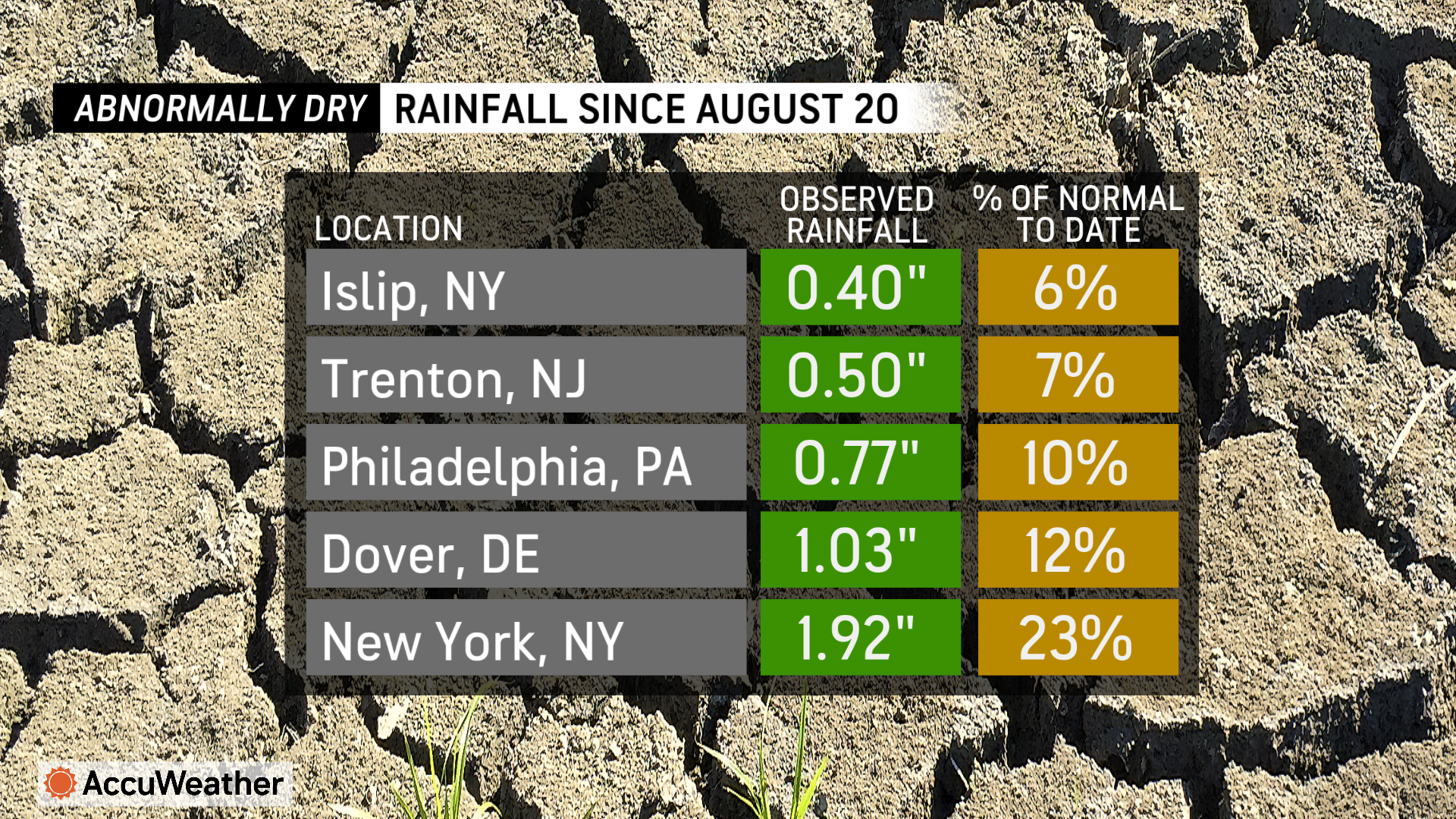
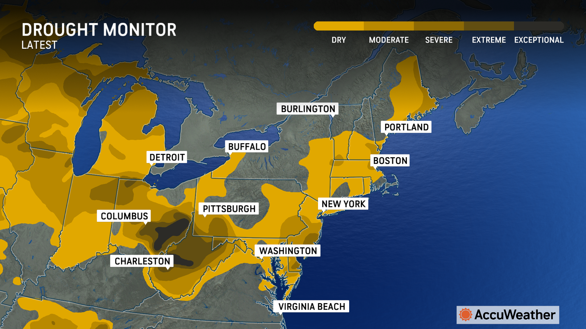
It has been weeks since enough rain fell to measure in New York, Philadelphia and Allentown, Pennsylvania, and Atlantic City, New Jersey. Abnormally dry to drought conditions have expanded considerably in the last month.
The last time there was 0.01 of an inch of rain or greater in Washington, D.C., was the first couple of days of October. It poured in the nation's capital on Oct. 1 with 1.46 inches of rain reported. That rain missed much of New Jersey, Delaware, eastern Pennsylvania, Maryland and southeastern New York.
Both Trenton, New Jersey, and the Atlantic City Marina have never had a drier 60-day period. Records date back more than 150 years to 1865 in Trenton and 1873 in Atlantic City. Trenton has received only 0.75 of an inch of rain in the last 60 days, with only 0.62 of an inch of rain at the marina as of Oct. 16.
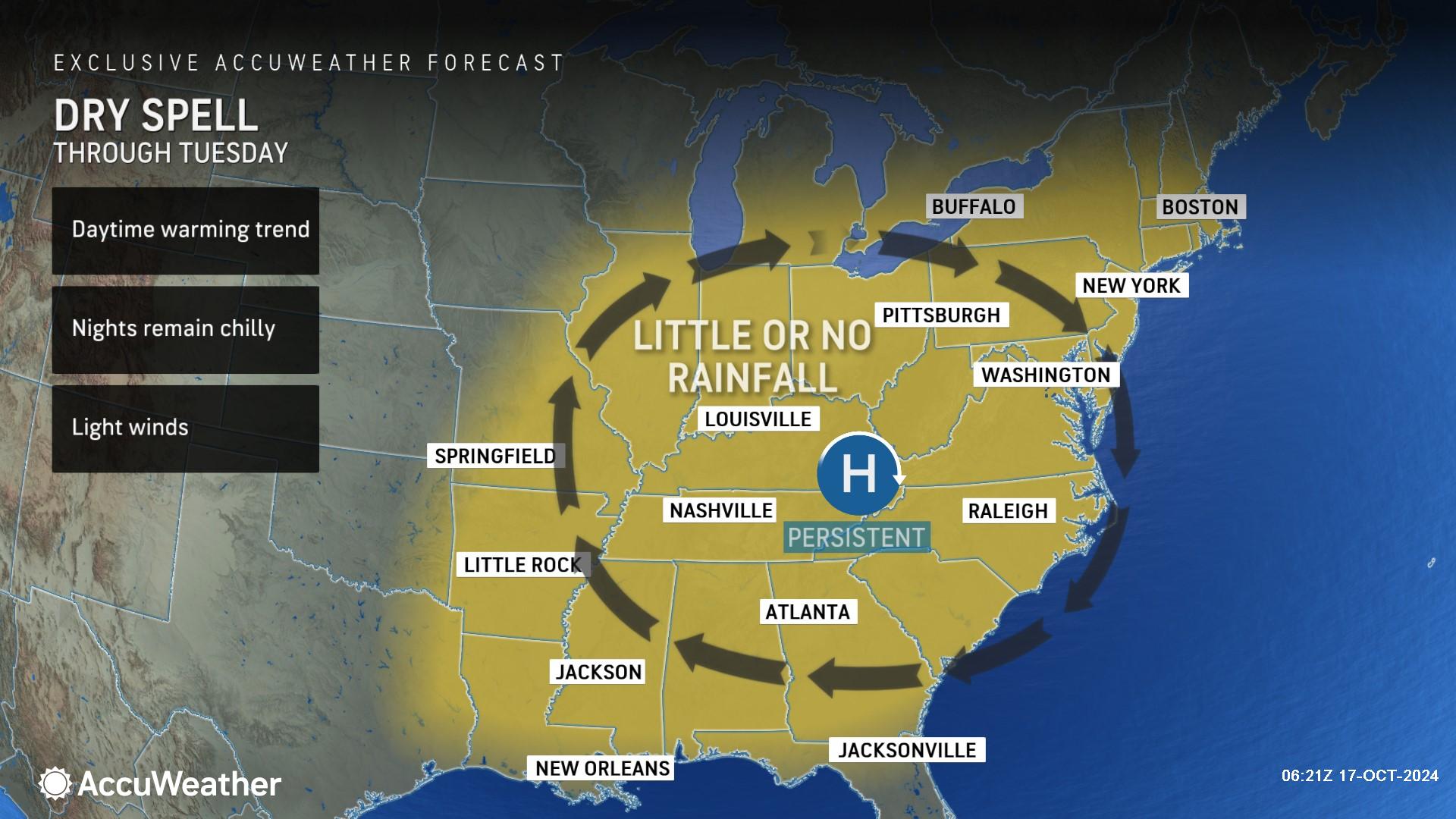
"The next chance of enough rain to thoroughly wet the ground will not come until at least the middle of next week for the mid-Atlantic region," said AccuWeather Senior Meteorologist Dave Dombek. "There is no guarantee it will rain much at all or everywhere that is experiencing the dryness."
After the opportunity for rain in the middle of next week, the next chance may not come until between Oct. 27 and 29.
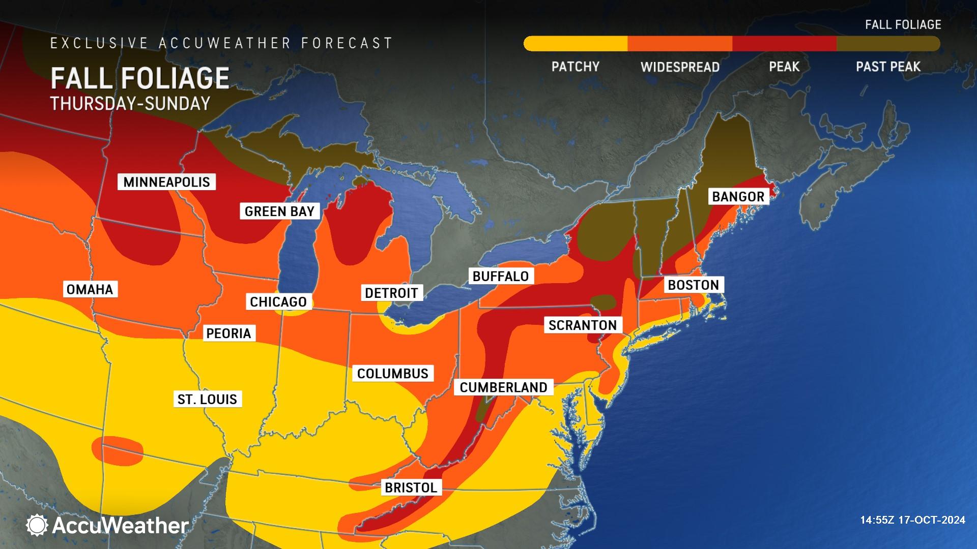
While the dry conditions have had minimal negative effects thus far, the dryness can stress some trees and lead to quick color changes and leaf drops. In many cases, however, the prolonged dry and warm conditions can extend the colorful viewing conditions.
AccuWeather expert meteorologists warn that the combination of dormant grass and fallen leaves in these dry conditions will raise the risk of catching fire if exposed to a spark from outdoor power equipment, cigarettes, downed power lines or sparks from chains dragging on roads or train tracks.
Windy conditions could substantially increase the risk of fires over the next couple of weeks or until drenching rain falls. An offshore storm over the Atlantic will lead to breezy conditions in coastal areas Friday. An approaching cool front toward the middle of next week may kick up some wind as well.
The dry landscape and air will allow big swings in temperature from the late night and early morning hours to the middle of the afternoon. Widespread highs well into the 70s and 80s are in store for the mid-Atlantic and much of the Northeast. The afternoons may be warm enough for shorts and short sleeves to be comfortably worn. The nights and start of the days may require a jacket and long sleeves. Temperatures will drop into the 40s and 50s in the mid-Atlantic and can sneak into the frosty 30s over the interior.
AccuWeather Forecast Graphics
Additional AccuWeather Resources:
How long will NYC, Philly and DC go without rain?
November-like chill in Northeast to be erased by warm weekend


