


AccuWeather meteorologists are available 24/7 to provide further insights and updates on evolving weather conditions. Please contact pr@accuweather.com during regular business hours, or support@accuweather.com or call AccuWeather’s Media Hotline at (814)-235-8710 at any time to arrange interviews with AccuWeather experts or to request the most updated graphics for print or broadcast.
Yet another tropical rainstorm forming in the Gulf of Mexico
June 21, 2024

> Flash flooding and mountain mudslides are expected along Mexico’s Gulf
coastline this weekend

> Downpours and storm surge could compound issues caused by Tropical
Storm Alberto earlier this week

> Drenching rain could reach areas dealing with drought in the Rio Grande
Valley of Texas
AccuWeather Global Weather Center – June 21, 2024
Just days after Tropical Storm Alberto brought deadly flooding and storm surge to Mexico, AccuWeather expert meteorologists are tracking another tropical rainstorm headed toward the same region.
Forecasters at AccuWeather’s Global Weather Center issued an AccuWeather Forecast EyePath® on Friday afternoon.
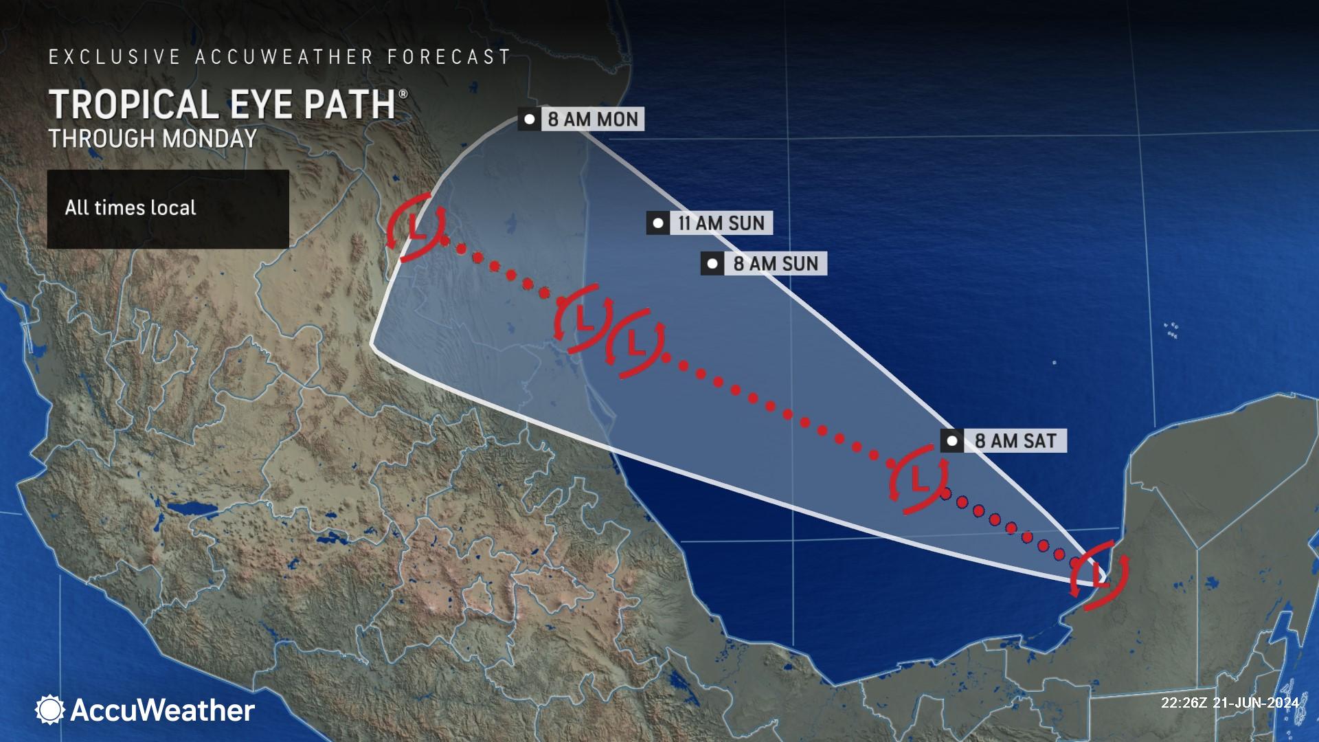
AccuWeather Lead Hurricane Forecaster Alex DaSilva said the tropical rainstorm is expected to make landfall Sunday morning near Tampico, Mexico.
It would need to strengthen with sustained winds of 39 mph or more before making landfall to be classified as a tropical storm. The next Atlantic storm name on the list is Beryl.
"This feature in the southwestern Gulf that we are monitoring is a piece of the Central America gyre that is breaking away and rolling west-northwestward this weekend," said AccuWeather Lead Tropical Meteorologist Alex DaSilva.
A gyre is a large, slowly spinning area of low-pressure that often enhances showers and thunderstorms in its circle of influence. A gyre over Central America and southern Mexico is common this time of the year. The gyre can contribute to tropical storm or hurricane formation over the Caribbean Sea, Gulf of Mexico, and the eastern Pacific Ocean.
Threat of Flash Flooding, Mudslides & Beach Hazards
AccuWeather Lead Hurricane Forecaster Alex DaSilva said the tropical rainstorm is expected to make landfall Sunday morning near Tampico, Mexico.
It would need to strengthen with sustained winds of 39 mph or more before making landfall to be classified as a tropical storm. The next Atlantic storm name on the list is Beryl.
"This feature in the southwestern Gulf that we are monitoring is a piece of the Central America gyre that is breaking away and rolling west-northwestward this weekend," said AccuWeather Lead Tropical Meteorologist Alex DaSilva.
A gyre is a large, slowly spinning area of low-pressure that often enhances showers and thunderstorms in its circle of influence. A gyre over Central America and southern Mexico is common this time of the year. The gyre can contribute to tropical storm or hurricane formation over the Caribbean Sea, Gulf of Mexico, and the eastern Pacific Ocean.
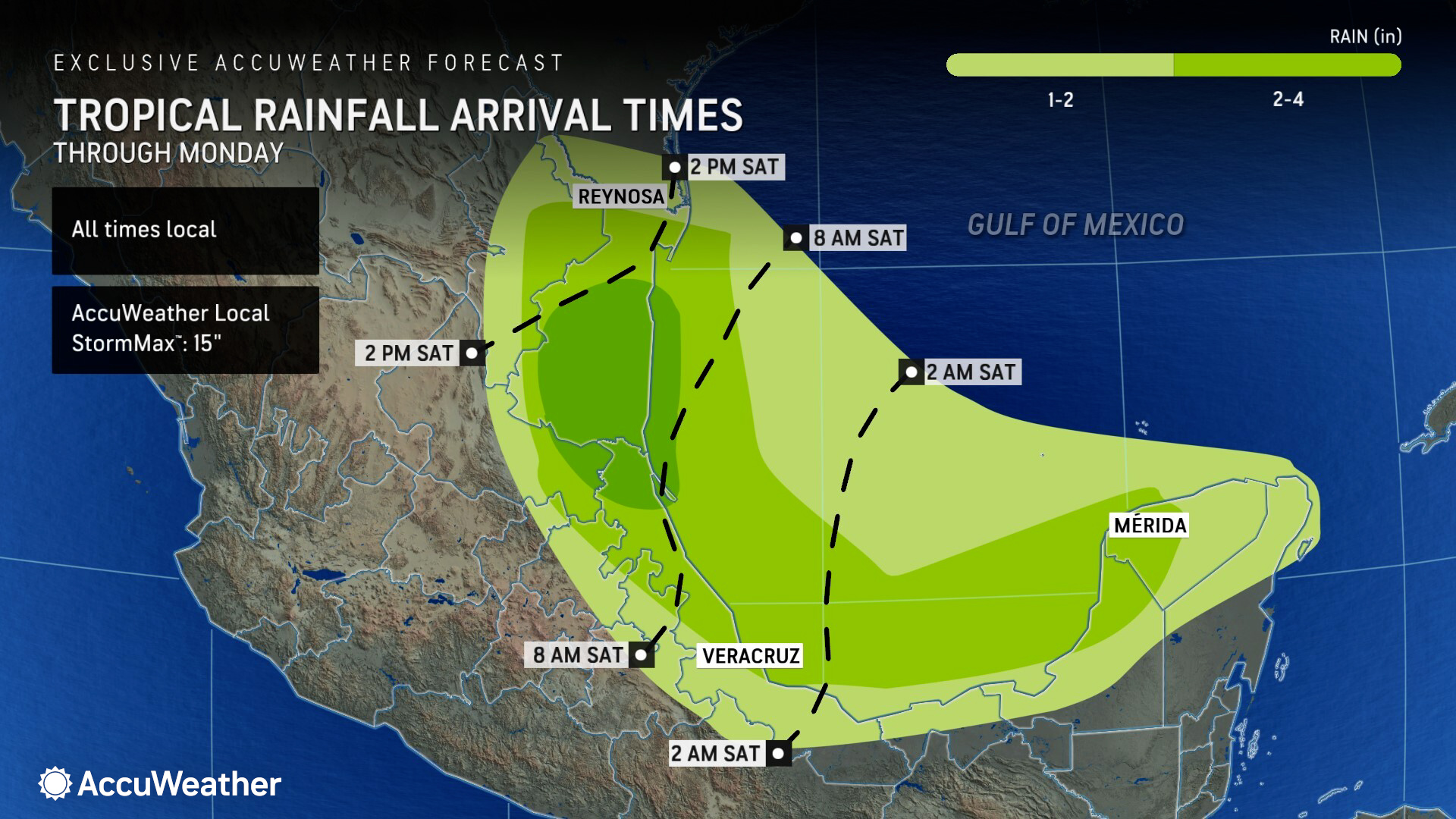
This tropical rainstorm is expected to bring heavy rain, storm surge, and rip currents to parts of northeastern Mexico and the lower Rio Grande Valley in southern Texas.
Much of this same area was impacted by Tropical Storm Alberto, which made landfall near Tampico, Mexico on June 20 with maximum sustained winds of 45 mph.
Alberto's broad circulation brought significant storm surge flooding as far to the north as the upper Texas coast. This tropical rainstorm is somewhat more compact and may track a bit farther to the south in Mexico.
A threat of just 1-3 feet of storm surge along the southern Texas coastline could lead to flooding issues since some protective buffers and dunes may have been compromised in the wake of Alberto.
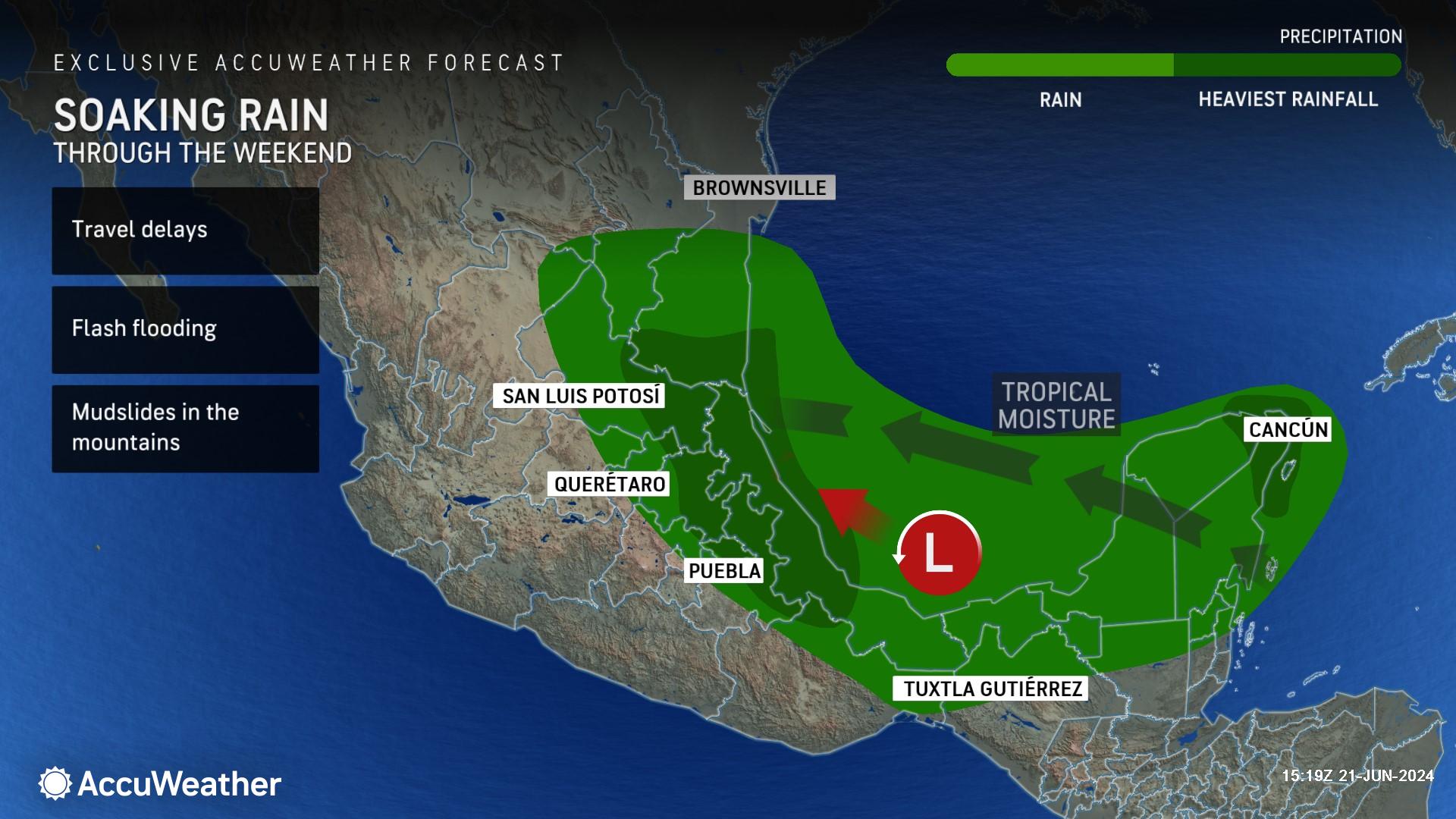
Widespread rainfall of 4-8 inches is expected in northeastern Mexico this weekend. AccuWeather expert meteorologists said some places along the coast and inland on the east-facing slopes of the mountains could pick up 8-12 inches of rainfall from the latest tropical rainstorm.
Up to 15 inches of rain is possible in the mountains of northern Mexico, according to the AccuWeather Local StormMax™.
DaSilva said the threat of flash flooding and mudslides in Mexico is significantly higher this weekend, as the rainfall will compound the impacts from Tropical Storm Alberto.
Portions of the lower Rio Grande Valley of Texas are currently experiencing long-term drought conditions. DaSilva said rain could be beneficial in South Texas, but downpours could also lead to dangerous flash flooding.
‘Explosive’ Hurricane Season on the Horizon
Following this tropical threat in the Gulf of Mexico, AccuWeather expert meteorologists say tropical threats in the Atlantic Basin will ease through the end of June.
DaSilva warns that a flurry of tropical threats are expected to return later this summer and into the early fall.
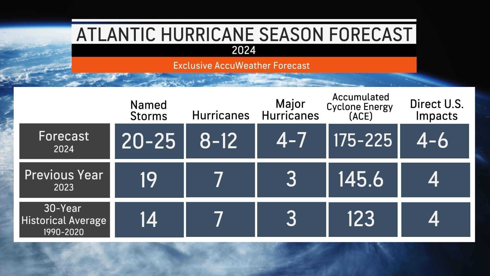
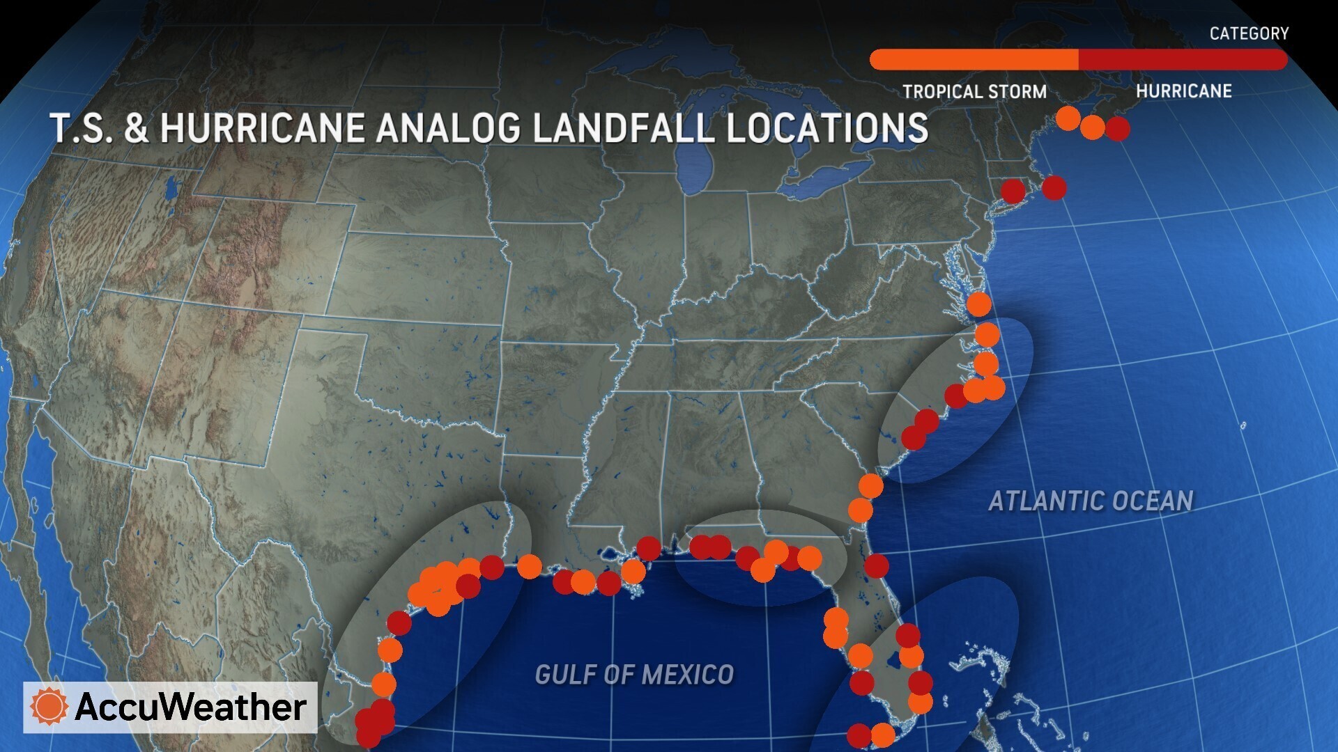
The AccuWeather 2024 U.S. Hurricane Forecast was the first source to warn the public in March of the threat of a super-charged hurricane season.
AccuWeather forecasts 20-25 named storms and 4-6 direct impacts to the United States this year.
DaSilva said the coastlines of Texas, Carolinas, South Florida, and Florida Panhandle face a heightened threat of direct tropical impacts this year, compared to the historical average.
AccuWeather also issued an alert in May warning families, businesses, and emergency leaders to prepare for the threat of rapidly intensifying tropical storms and hurricanes near the coast this season.

“2023 is the benchmark for the warmest that the Atlantic basin has ever been in recorded history,” said DaSilva. “Tropical storms and hurricanes love to feed off of warm ocean water. The warmer the oceans are, the more favorable the environment will be for tropical development and intensification.”
Additional AccuWeather Resources:
Southwest Gulf on alert for new tropical development
AccuWeather Forecasts Explosive 2024 Hurricane Season
Rapidly Intensifying Hurricanes Near Coastline Pose Major Threat To U.S. This Season
2024 hurricane season names: Is your name on the list?
Two hurricane names, including deadly Category 5, retired after destructive impacts in 2023


