AccuWeather meteorologists are available 24/7 to provide further insights and updates on evolving weather conditions. Please contact pr@accuweather.com during regular business hours, or support@accuweather.com or call AccuWeather’s Media Hotline at (814)-235-8710 at any time to arrange interviews with AccuWeather experts or to request the most updated graphics for print or broadcast.
Hurricane Beryl blasts Jamaica with life-threatening storm surge and destructive winds
July 3, 2024
> Catastrophic impacts are possible in Jamaica from fierce winds and deadly
storm surge

> Vacation hotspots in Mexico’s Yucatan Peninsula could experience damaging
winds

> Swells from Beryl will create a dangerous rip current risk along the Texas
coastline and along much of the U.S. Gulf Coast
AccuWeather Global Weather Center – July 3, 2024
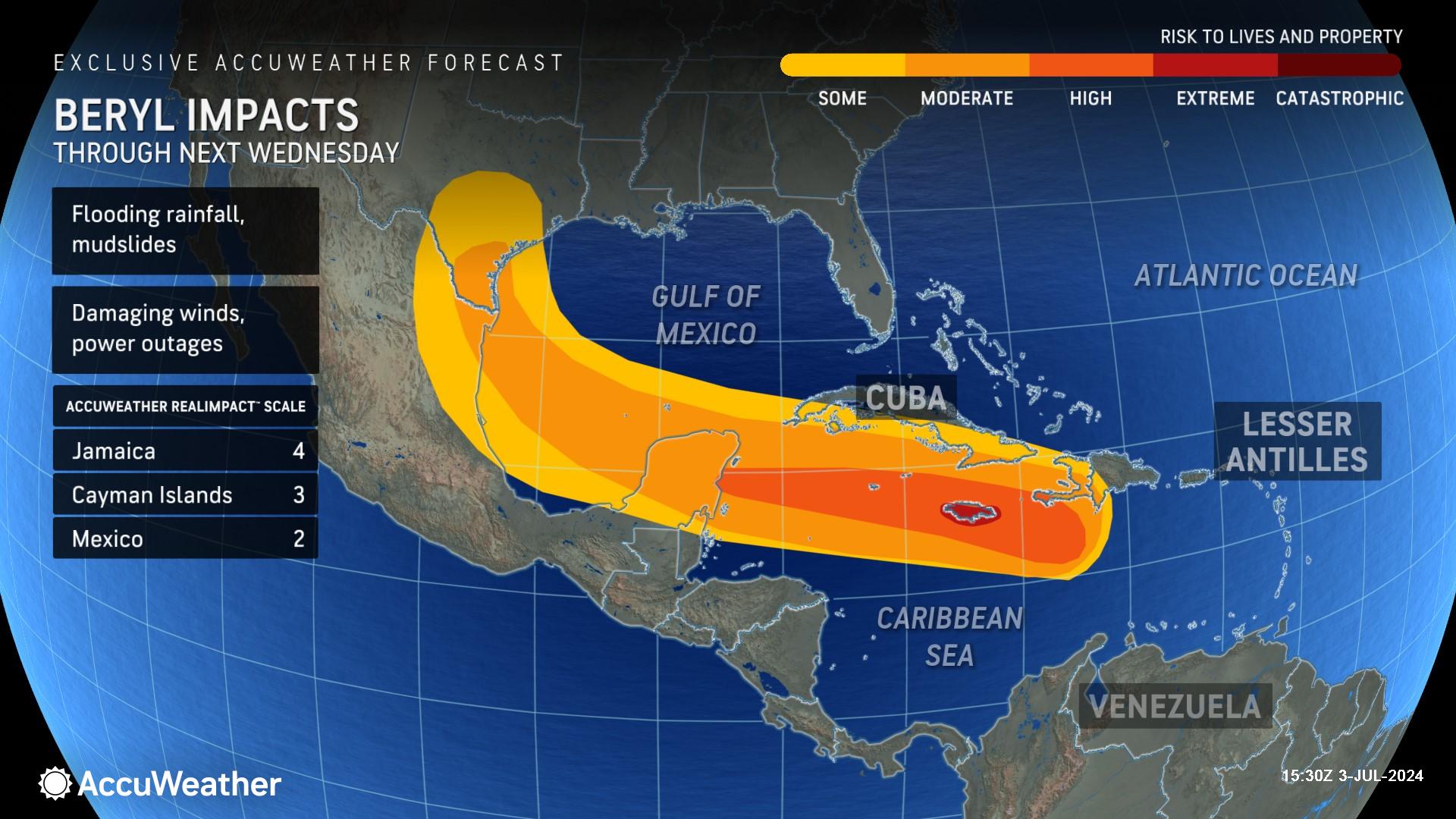
AccuWeather expert meteorologists say Hurricane Beryl will bring life-threatening storm surge, flooding rain, and destructive winds to parts of Jamaica and the Cayman Islands over the next 24 hours.
“We’re concerned about widespread damage and potentially catastrophic impacts in Jamaica,” warned AccuWeather Chief On-Air Meteorologist Bernie Rayno. “Flooding may last days to even weeks. Widespread power outages are expected. Beryl will likely damage many homes and businesses and cause severe coastal inundation. I fear that the extensive damage we’ve seen on the islands of Carriacou and Grenada will be repeated in Jamaica.”
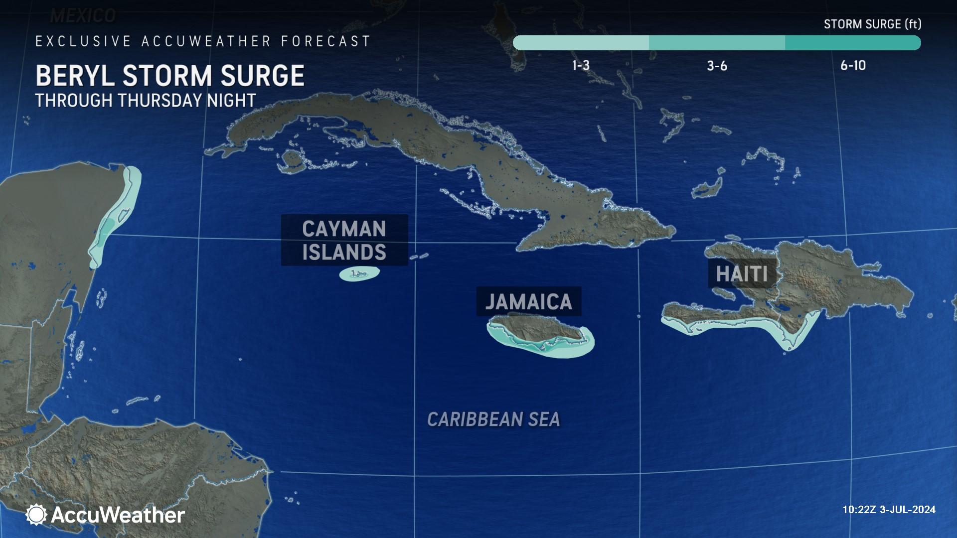
Rayno says portions of the southern coastline of Jamaica could be slammed with 6-10 feet of storm surge.
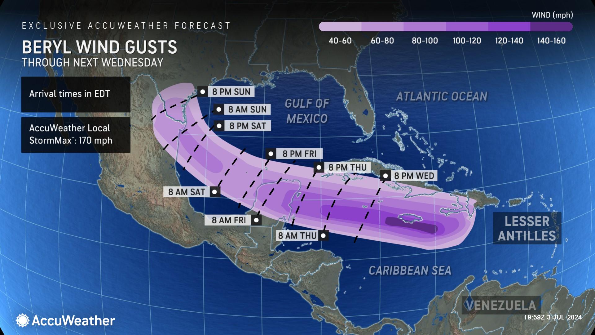
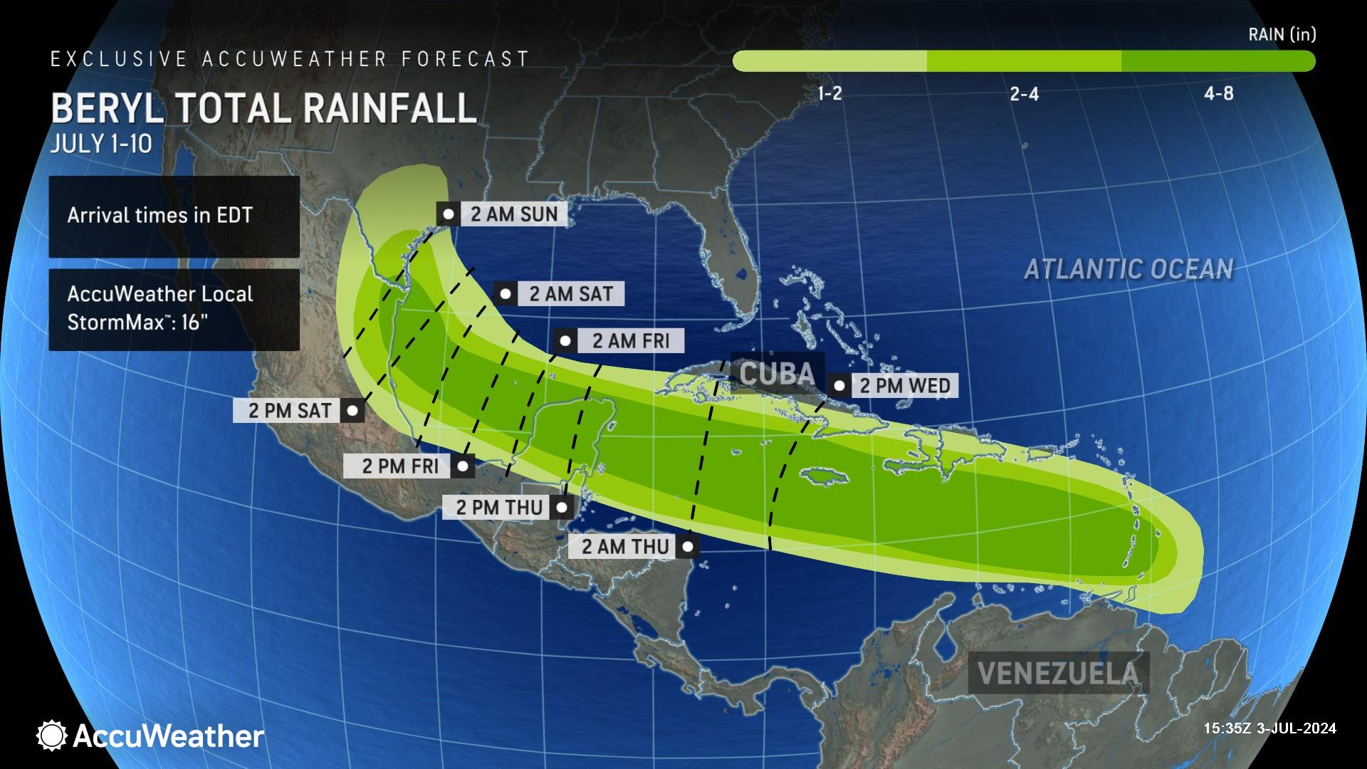
Southern areas of the island could be blasted by sustained maximum winds above 100 mph and 4-8 inches of rain.
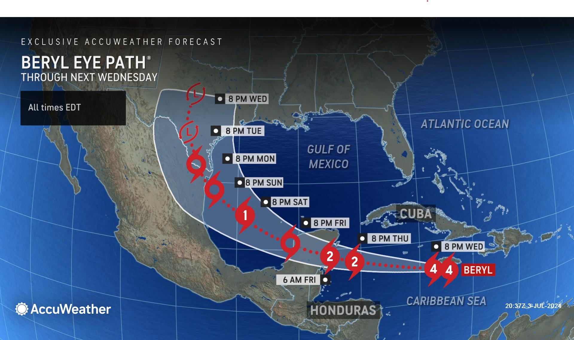
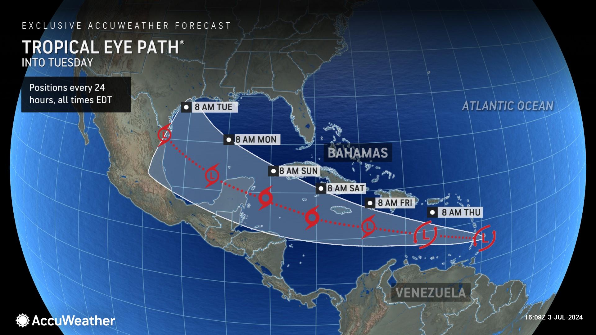
The eye of Hurricane Beryl is expected to pass less than 50 miles to the south of Kingston, Jamaica, which will put part of Beryl's destructive eyewall near the southern coast of the island.
Beryl made history earlier this week as the fastest-moving Category 5 hurricane and the earliest Category 5 hurricane on record in the Atlantic basin.
“We are extremely concerned about Kingston in the southeastern corner of Jamaica,” said AccuWeather Lead Hurricane Expert Alex DaSilva. “Deadly storm surge is expected, as well as mudslides in mountainous areas.”
The AccuWeather RealImpact™ Scale for Hurricanes for Jamaica is a 4, which warns of catastrophic flooding, widespread power outages, structural damage to many buildings near the coast, and severe coastal inundation.
After Beryl moves west of Jamaica, the hurricane is expected to pass south of the Cayman Islands late Wednesday night into early Thursday morning.
AccuWeather expert meteorologists are warning people in the Cayman Islands to prepare for widespread flooding, damage to buildings, and extended power outages.
Beryl takes aim at Mexico
After impacting islands across the Caribbean, Beryl is expected to approach the Yucatan Peninsula of Mexico as a Category 2 hurricane on the Saffir-Simpson scale with maximum sustained winds of 96-110 mph early Friday morning.
“Residents, businesses, and tens of thousands of tourists in the region need to be prepared for dangerous conditions and the possibility of power and communication outages,” said AccuWeather Chief Meteorologist Jon Porter. “Beryl will likely disrupt travel out of popular vacation hotspots and airports in the Tulum area.”
Impacts expected along the U.S. Gulf Coast
The track that Beryl takes across the Yucatan Peninsula will influence where Beryl eventually emerges in the Gulf of Mexico and later makes another landfall, which is expected near the border of northern Mexico and southern Texas.
“The key is going to be the strength of Hurricane Beryl as it moves over the Yucatan Peninsula. If the storm is a little bit stronger, it is more likely to be picked up by a dip in the jet stream and track closer toward Texas,” said DaSilva. “If the storm loses intensity due to land interaction over the Yucatan, it’s more likely to continue moving west directly into Mexico.”
Beryl is forecast to make landfall along the Gulf Coast near the border of Mexico and the United States on Sunday night or Monday morning as a tropical storm. AccuWeather expert meteorologists say they cannot rule out the possibility that Beryl could maintain intensity over the warm waters and make landfall as a Category 1 hurricane.
Rayno says an area of high pressure over the southern United States will also be a major factor.
"If the high-pressure area were to remain strong, Beryl would make landfall in southeastern Mexico late Thursday night or Friday morning and then remain mostly over land for its duration," said Rayno. "But if the high weakens just a bit, and we are seeing signs of that trend, it will allow Beryl to take a more north-northwesterly track, in which case it may avoid more land and get into the southwestern Gulf of Mexico as a formidable hurricane instead of a chopped-down tropical storm that encounters more land."
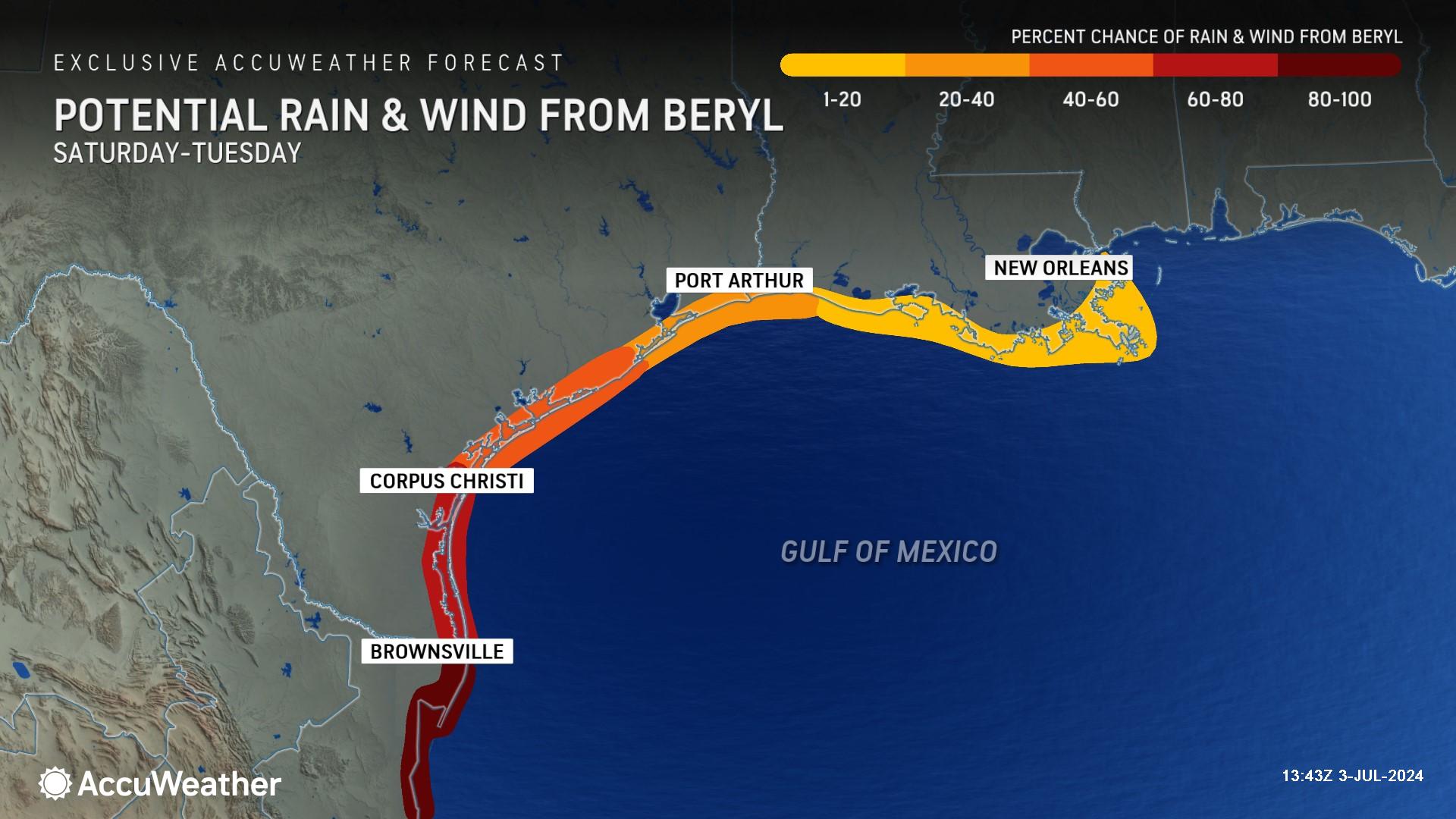
Due to the increasing potential for Beryl to turn more to the north soon after passing over the Yucatan Peninsula, families and businesses along the Texas coast should closely monitor AccuWeather forecast updates. Despite the risk, Beryl would not approach southern Texas with the same intensity as that of the Windward Islands. However, there could still be significant rain, gusty winds, and storm surge.
“This is going to be a different storm after it passes the Yucatan Peninsula. It’s going to be a slow-moving storm,” said Porter. “The risk of rain and wind impacts is increasing from Brownsville, Texas and areas south through northern Mexico.”
AccuWeather expert meteorologists are forecasting 4-8 inches of rain across parts of southern Texas and northern Mexico.
“My concern is that this storm will slow down as it moves inland,” said DaSilva. “Beryl could end up meandering over northern Mexico and southern Texas and dump a lot of rain.”
Swells from Beryl could also create dangerous rip currents at beaches along northern Mexico and across the Texas coastline this weekend. Rip currents are possible along the entire Gulf Coast as far away as southwestern Florida and the Florida Keys.
Another tropical threat following Beryl’s path
AccuWeather expert meteorologists are also monitoring a cluster of thunderstorms in the Windward Islands, bringing rain and wind to islands that were hit hard by Beryl.
AccuWeather meteorologists have been calling the threat a tropical rainstorm since late last week to help raise public awareness.
The rain and wind from this tropical rainstorm could impact recovery efforts and further compromise homes, businesses, and infrastructure that were damaged when Beryl made landfall in Carriacou on Monday as a Category 4 hurricane with 150 mph sustained winds.
At this time, there is a low to moderate risk of the tropical rainstorm developing into a tropical storm or hurricane this week as it takes a very similar track to Beryl. Since waters have been churned up by Beryl in the path of the system, this tropical rainstorm is unlikely to reach the same intensity as Beryl.
AccuWeather Forecast Graphics
Additional AccuWeather Resources:
Dangerous Hurricane Beryl blasting Jamaica while racing across Caribbean
Category 5 Hurricane Beryl rewrites the record books
What is wind shear and how does it impact hurricanes, other tropical cyclones?
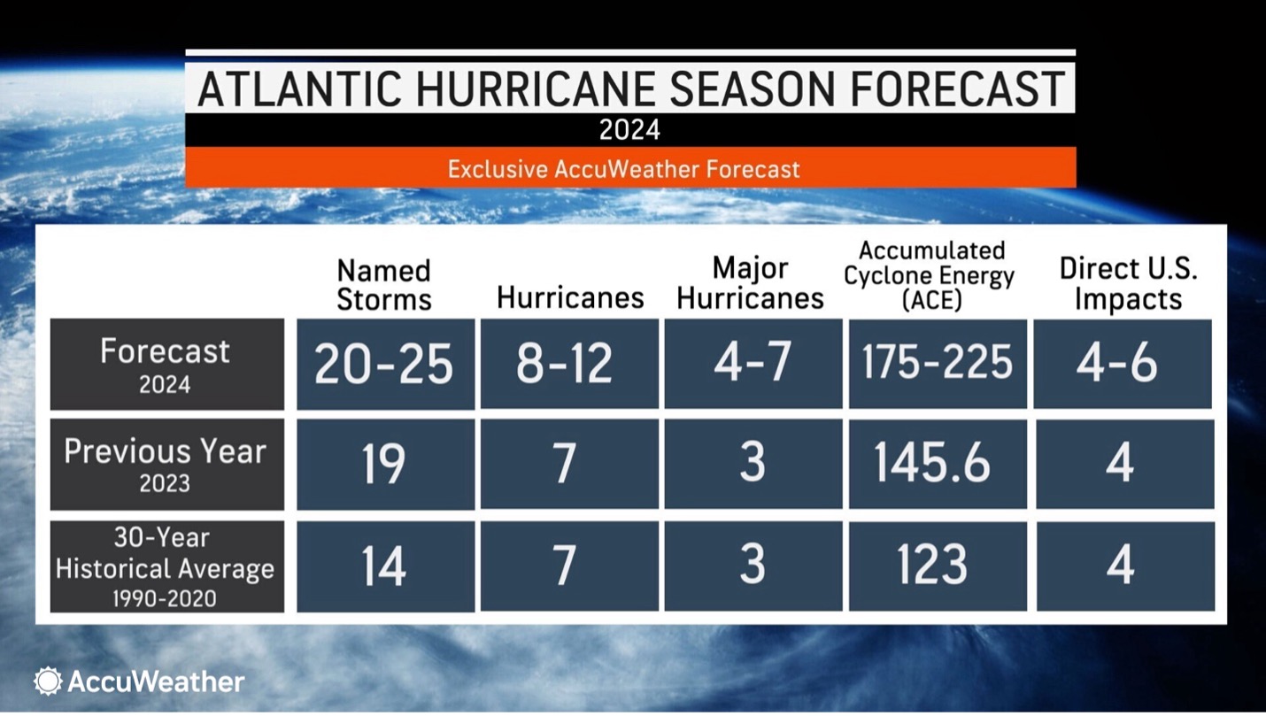
AccuWeather Forecasts Explosive 2024 Hurricane Season
Rapidly Intensifying Hurricanes Near Coastline Pose Major Threat To U.S. This Season
Hurricane season: AccuWeather's guide for first-timers


