


AccuWeather meteorologists are available 24/7 to provide further insights and updates on evolving weather conditions. Please contact pr@accuweather.com during regular business hours, or support@accuweather.com or call AccuWeather’s Media Hotline at (814)-235-8710 at any time to arrange interviews with AccuWeather experts or to request the most updated graphics for print or broadcast.
February Frenzy: Three winter storms in the next week to pack dangerous, disruptive punch across U.S.
Feb. 7, 2025

> Weekend storm to bring large swath of at least 3-6 inches of snow from Minneapolis to Boston. It could rival Boston’s biggest snowstorm so far this winter.
> Two storms next week bring the greatest risk of widespread plowable snow from Washington, D.C., to New York City so far this season.
> Cumulative snowfall over the next two weeks can be 2-3 feet across a zone stretching from interior New York to parts of New England, including Binghamton and Syracuse, New York, as well as Montpelier, Vermont, and potentially, Boston, Massachusetts.
|
Passcode: D*k2SC66
|
AccuWeather Global Weather Center – Feb. 7, 2025
AccuWeather expert meteorologists say families and businesses across more than 20 states will face relentless rounds of winter storms and hazardous travel conditions that will linger into late February.
“This is the stormiest stretch of the winter with a February frenzy of winter storms every few days in many places. This is a very active coast-to-coast storm track with impacts from the West Coast through the Central Plains into the mid-Atlantic and Northeast,” AccuWeather Chief Meteorologist Jonathan Porter said. “It’s been a disruptive start to February, and this onslaught of winter storms is expected to stick around for most of the month. Millions of people are dealing with daily disruptions to life, including slippery and dangerous commutes to work, school delays and cancellations, business and supply chain disruptions, and travel disruptions at major airports from the Midwest to the Northeast and mid-Atlantic. Many people with the option to work remotely will stay home, while essential and frontline workers may face slippery and hazardous commuting conditions.”
AccuWeather’s team of long-range experts accurately predicted in September that February would be an exceptionally active month for winter weather impacts across the country, especially in the Northeast.
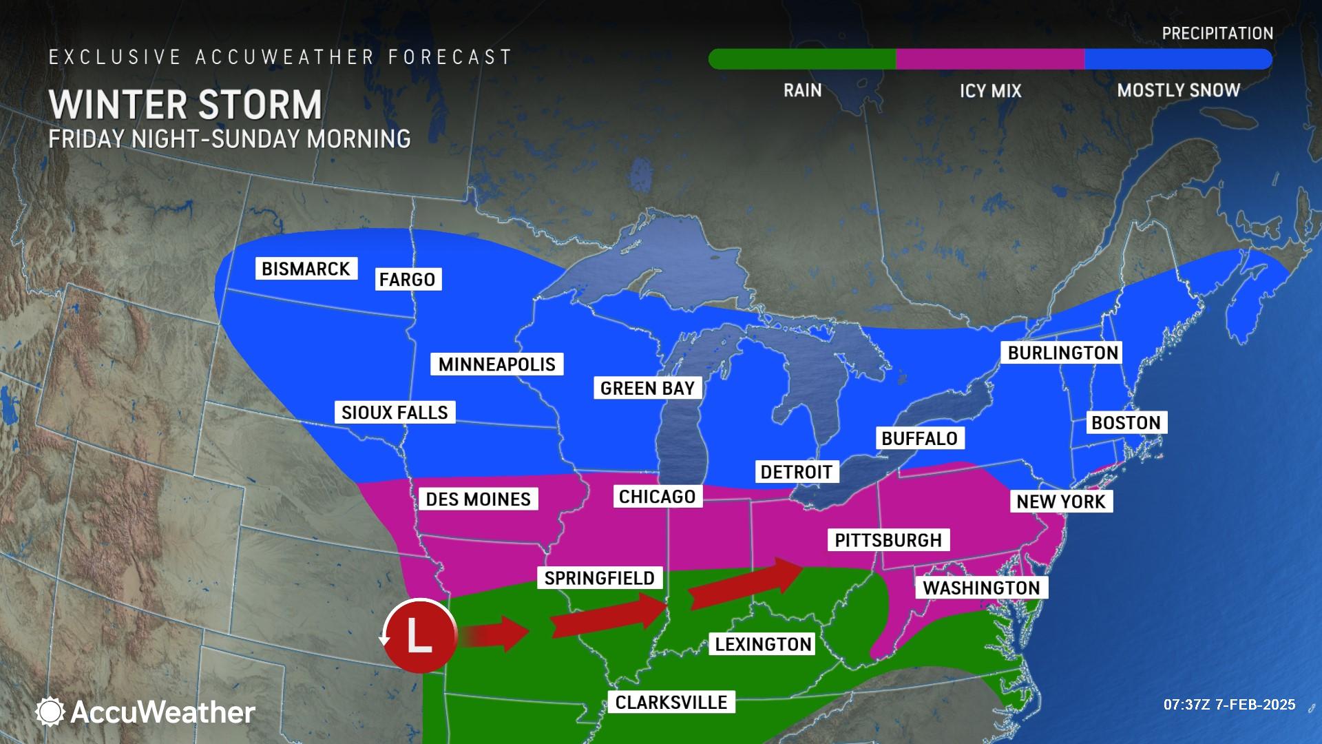
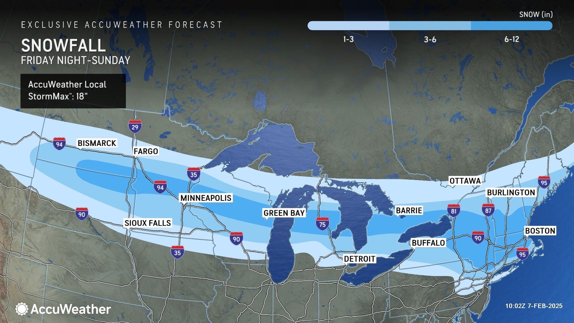
Weekend winter storm
AccuWeather expert meteorologists say the second winter storm of the week will bring accumulating snow from the northern Plains and Great Lakes to the Northeast from Friday night through Sunday. The storm will bring more snow and ice to many spots already hit by winter weather earlier in the week.
Plowable snow of 3 inches or more is expected from the Dakotas eastward through Maine. The AccuWeather Local StormMax™ across the region is 18 inches.
In the Northeast, many locations could receive more snow than what occurred on Wednesday night and Thursday when sleet and freezing rain mixed with the snow. On Saturday night, snow can accumulate quickly from New York to Boston, with the risk of more than three inches of snow not too far north of New York City. In Boston, this storm has the potential to rival the biggest of the season so far. AccuWeather is currently predicting 4-8" of snow for Boston.
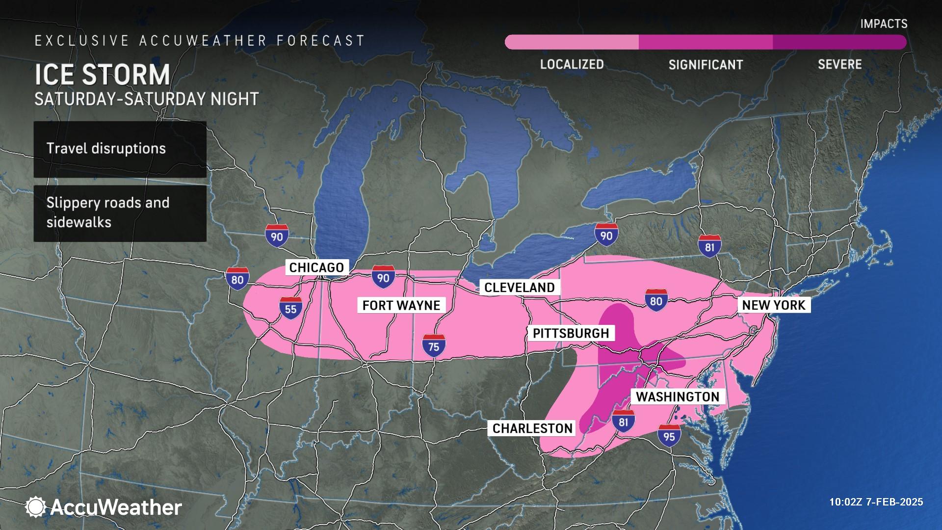
Icy impacts are expected on the southern side of the storm from the Midwest through parts of the Ohio Valley and the central Appalachians into the mid-Atlantic.
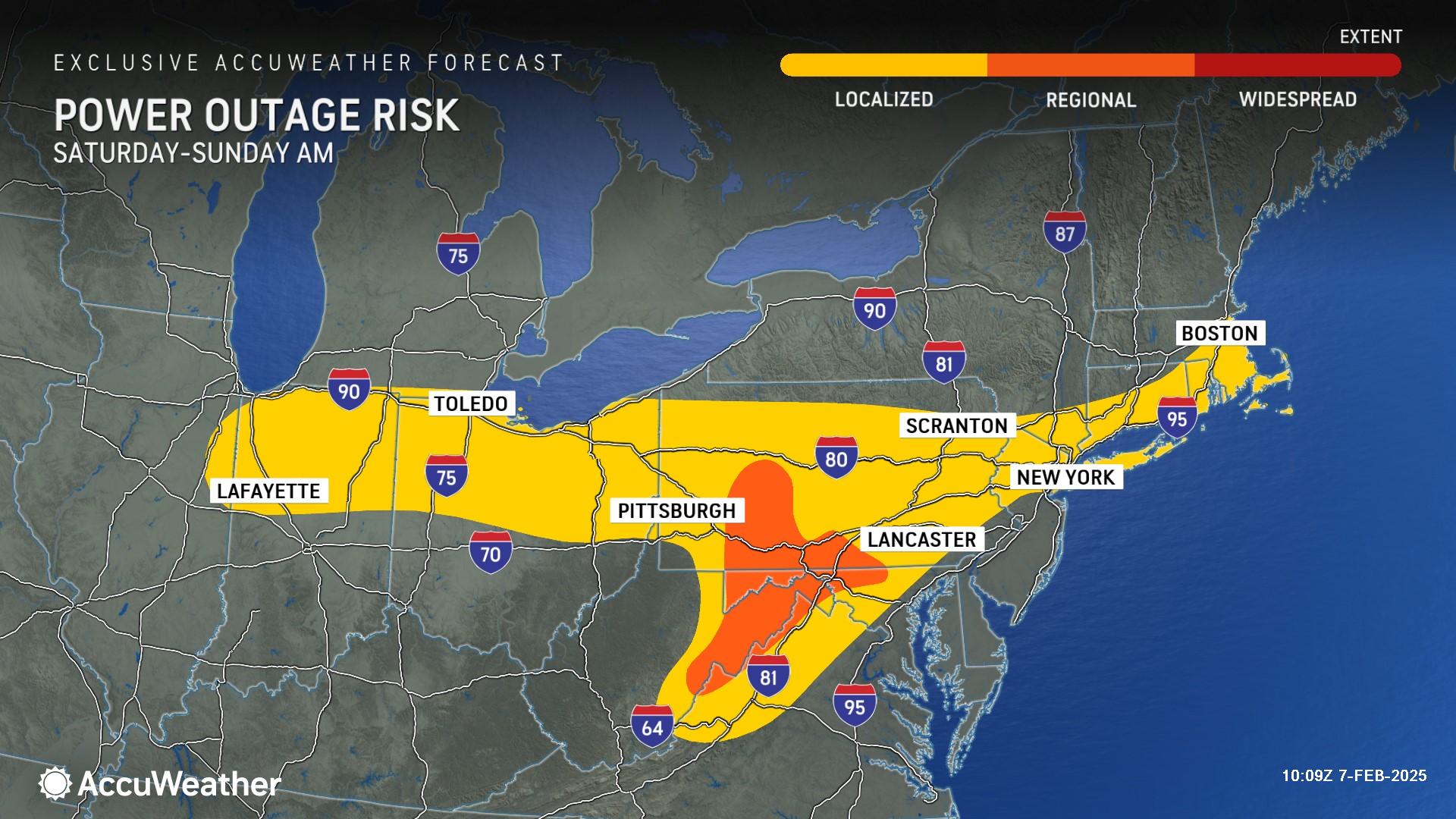
“A small ice accumulation can cause major problems. Ice accretion adds extra weight to power lines, which can cause sagging and lead to utility damage. Tree limbs coated in ice can snap and fall on utility lines, knocking out power, internet, phone, and cable service. Tree branches coated on ice can fall onto houses,” AccuWeather Senior Director of Forecasting Operations Dan DePodwin said.
The most significant risk of icing lies across a swath of northern Ohio and across the Laurels through northeastern Pennsylvania, where more than a quarter inch of ice buildup is possible.
“Travel in these conditions can be very dangerous. There is little to no traction on icy and sleet-covered roads and highways. We don’t want anyone to let their guard down. Every single winter storm is different; if ice did not accumulate during the last storm in your neighborhood it doesn’t mean it won’t during this next storm. Slight temperature and elevation changes can make a huge difference in winter storm impacts,” DePodwin warned.
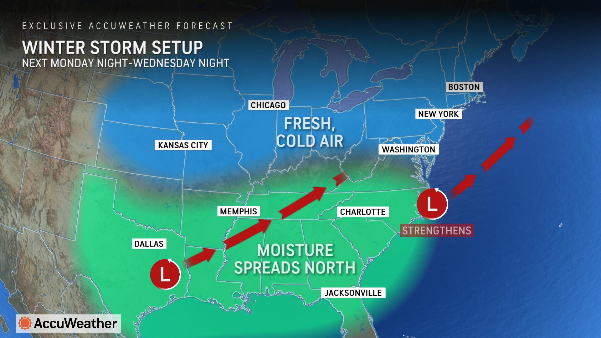
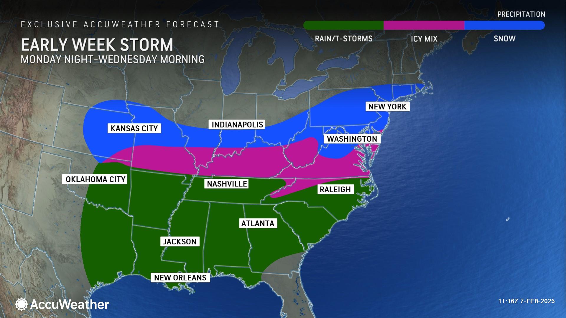
Winter storm threat next week
AccuWeather expert meteorologists say a third winter storm is expected to evolve on Monday as cold air expands farther south and meets up with moisture spreading north from the Gulf.
This can lead to a large area of accumulating snow that may impact millions from the central Plains to New England.
“Next week’s winter storm stands out from the rest. It has the potential to be more intense and widespread, with a fresh supply of cold enough air to support significant and plowable snow across parts of the Northeast and mid-Atlantic,” Porter explained. “As one storm system over Texas traverses north towards the Appalachians, another storm is expected to develop off the East Coast. This is a recipe for significant snowfall. People in the Midwest, mid-Atlantic, and Northeast should be prepared for disruptive to significant snowfall accumulations next week, including Boston and New York City.”
This early-week storm could be the best chance so far this winter for widespread plowable snow in the corridor from Washington, D.C., to New York City. Most storms this winter have only impacted part of that I-95 region with snow due to borderline temperatures that have caused snow to mix with and change over to rain and sleet.
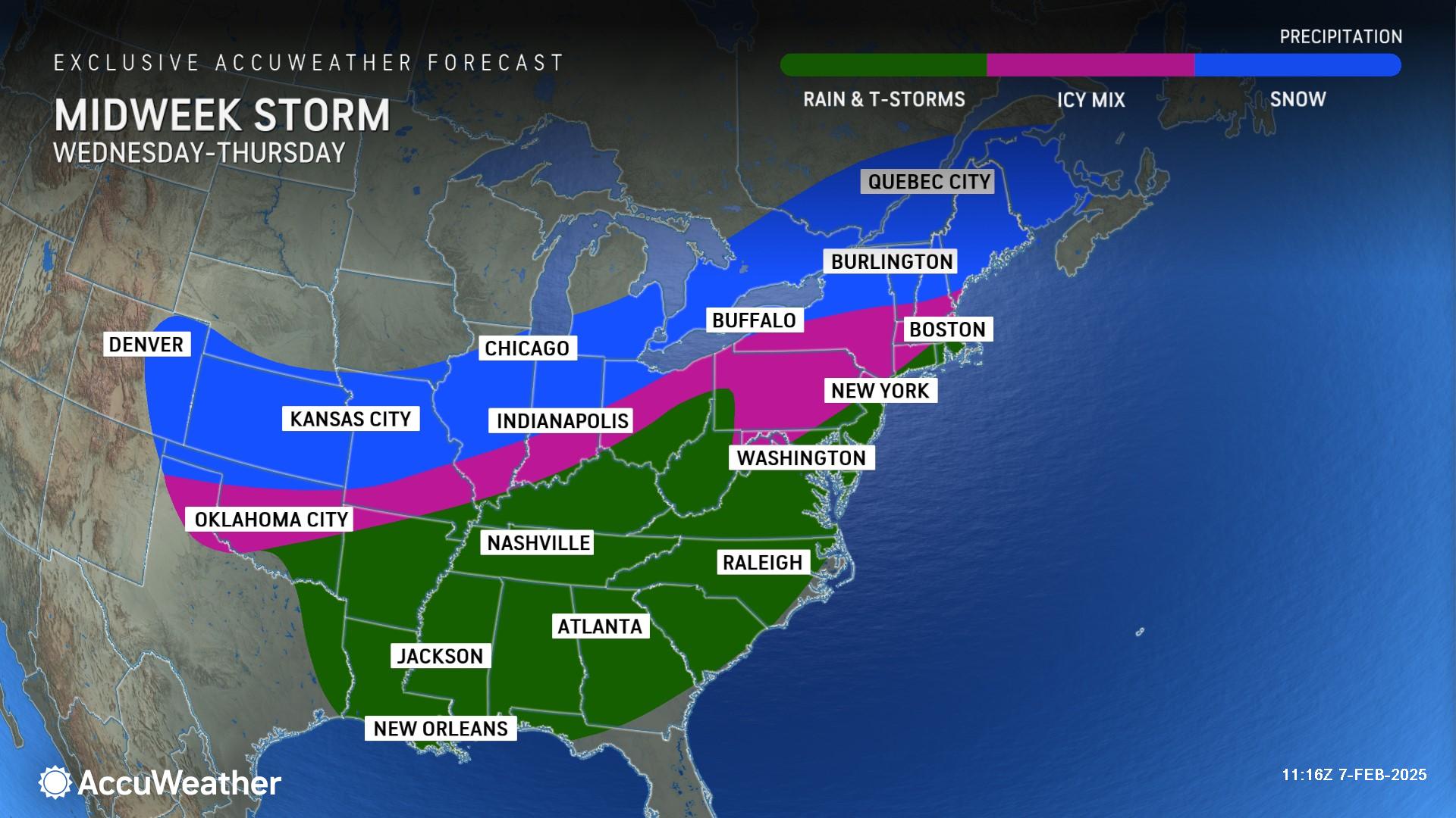
AccuWeather long-range experts say there can be yet another winter storm later next week in the Northeast. Due to slightly less cold air ahead of the storm, this late-week storm might track farther north than Tuesday’s snow, increasing the risk for yet another plowable snowstorm in New England.
The relentless pattern is expected to continue with yet another winter storm between Feb. 16-18 that could be the most intense of the stretch and track farther north. This could result in more rain than snow in the mid-Atlantic and Northeast, with snow potential confined to the Ohio Valley, Great Lakes and Midwest.
During the final 10 days of February, an additional one or two winter storms may form and take a similar track from the Southwest to the Northeast, tracking across the Plains, Tennessee and Ohio Valleys, into the mid-Atlantic and Northeast.
Throughout this stormy pattern, AccuWeather long-range experts say cumulative snowfall totals be 2-3 feet across a zone stretching from interior New York to parts of New England, including Binghamton and Syracuse, New York, as well as Montpelier, Vermont and potentially, Boston, Massachusetts.
Benefits of back-to-back winter storms
The relentless rounds of winter storms are creating dangerous and disruptive impacts, but Porter says the snow and rain have beneficial effects.
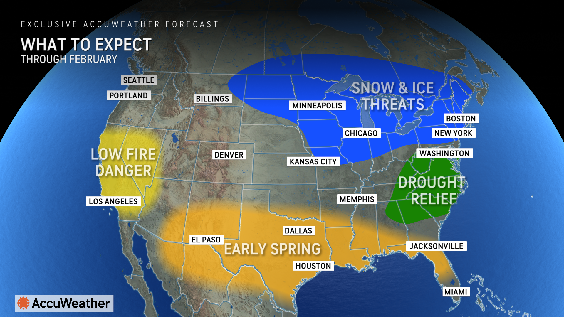
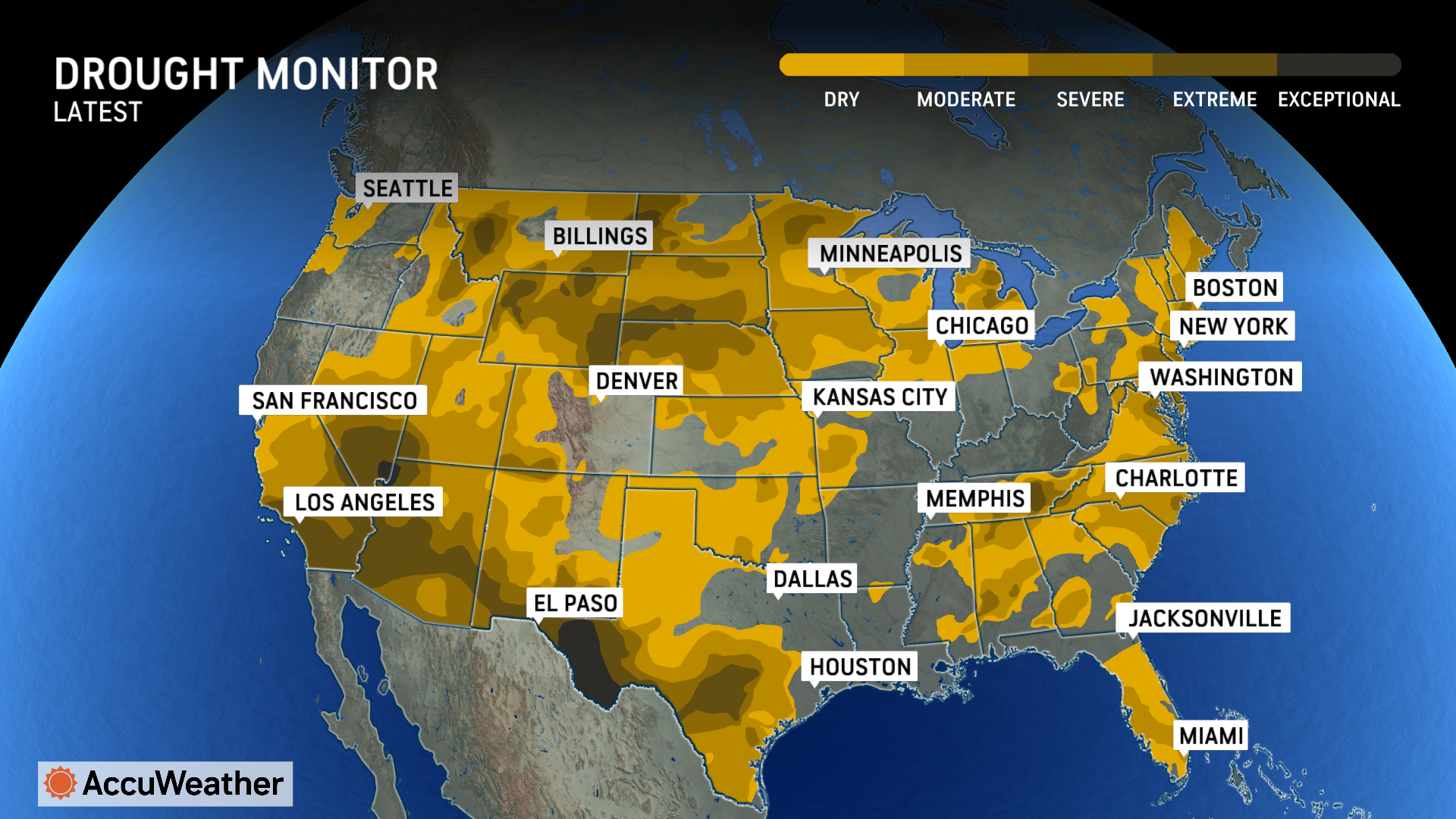
“Two places seeing some benefits from these winter storms are the mid-Atlantic and Southeast. Frequent rounds of rain will help the short-term drought situation,” Porter said.
Abnormally dry or drought conditions have been reported across 69 percent of the contiguous U.S. this week, compared to roughly 64 percent last week.
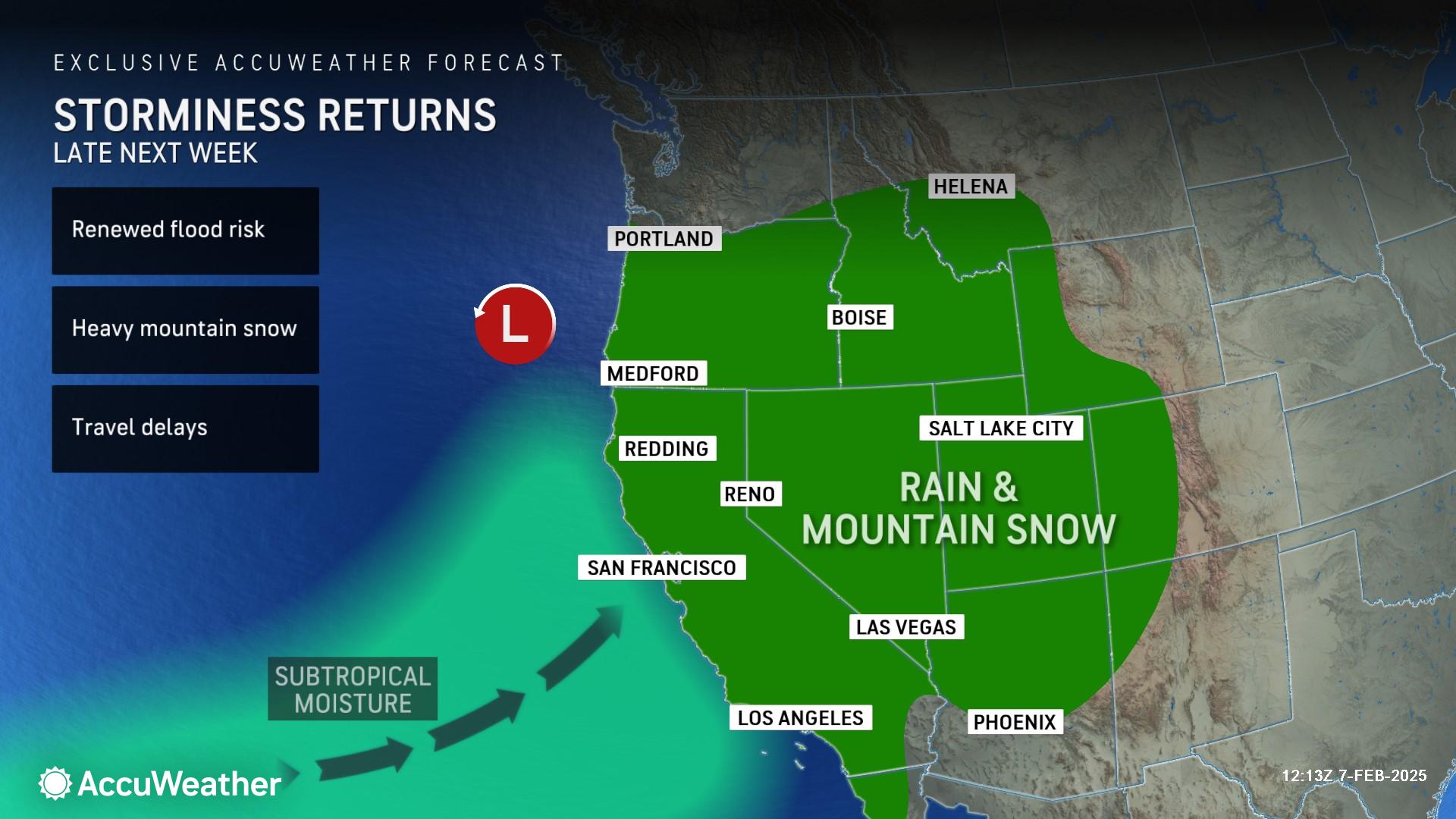
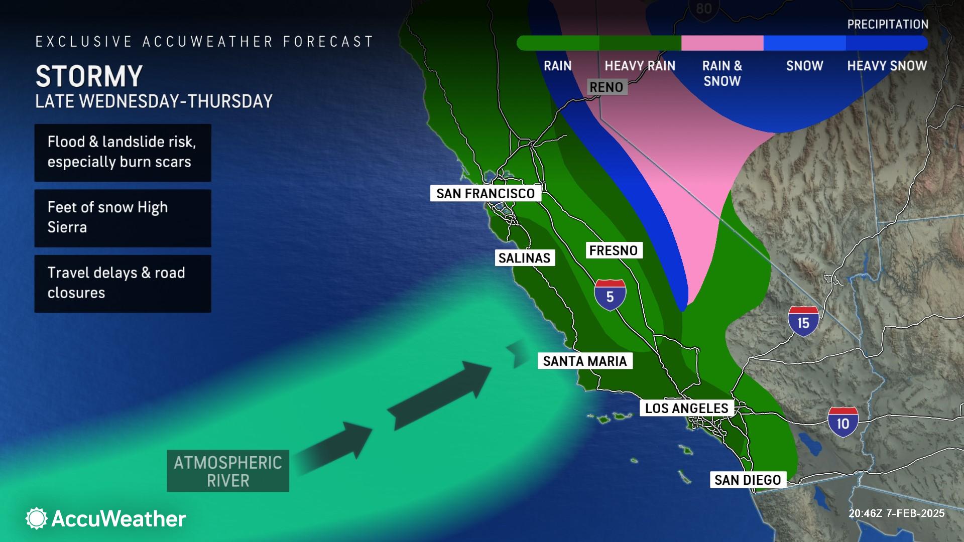
“Much-needed rainfall has greatly reduced the risk of wildfires across Southern California and much of the state,” Porter said. “Most reservoirs across California are filled to levels well above historical average. The mountain snowpack is above the historical average in the Northern Sierra. That’s good news for California’s water supply this summer.”
AccuWeather expert meteorologists caution that heavy rainfall can trigger dangerous mudslides and destructive debris flows in recent burn scars across Southern California following catastrophic wildfires last month. AccuWeather’s preliminary estimate of the total damage and economic loss from the January wildfires in Southern California is between $250 billion and $275 billion.
AccuWeather Lead Long-Range Expert Paul Pastelok says drought is forecast to expand across Southern California and the Southwest this spring, with above-historical average temperatures expected across the region.

Additional AccuWeather Resources:
New Year’s Eve weather is shaping up rainy for some popular destinations in US
Dramatically colder, snowier days ahead for 1st half of January in Midwest, East and South
How does the polar vortex lead to Arctic outbreaks?
Extreme weather events are happening more often, having a larger impact on the national economy


