


Atmospheric rivers to fuel the 2 biggest storms of the winter in California
|
California is bracing for one-two punch from storms packing atmospheric rivers, and the second storm could prove to be the stronger of the two, endangering lives and property and hampering travel into the start of next week. |
|||
February 01, 2024

AccuWeather Global Weather Center – February 01, 2024
A meteorological double-whammy will pound the West Coast with heavy rain and mountain snow, starting with one storm that will last into Thursday night and be quickly followed by another storm Sunday to Monday. Both will tap into moisture from atmospheric rivers, heightening the flood risk for millions, AccuWeather expert meteorologists warn.
The proximity of the second storm to the first, hitting roughly the same areas, could escalate flooding, mudslides and power issues. Rounds of large waves from both storms will pummel the California coast into next week. There will be the potential for overwash, coastal erosion and property damage.
Timing, impacts from the 1st storm
The first storm will continue to funnel copious amounts of moisture like a giant firehose southward through California into Thursday night before shifting inland over the southwestern United States from Friday to Saturday.
Satellite images on Wednesday morning showed clouds from the storm spanning nearly 2,000 along the Pacific coast from Los Angeles to Juneau, Alaska.
Much of Northern California was on the receiving end of 1-4 inches of rain into Thursday. Similarly, coastal areas of Southern California can expect 1-4 inches of rain, with several tenths of an inch to 1 inch likely over the interior deserts into Thursday night. In both Northern and Southern California, locally higher first storm total amounts of 4-6 inches are likely along the west- and southwest-facing Coast Ranges with an AccuWeather Local StormMax of 7 inches.
The rain from the first storm will be heavy enough to lead to incidents of flash urban flooding.
Strong winds from the first storm will be most widespread in Northern and Central California into Thursday, where gusts frequenting 40-60 mph are in store and an AccuWeather Local StormMax™ of 85 mph. At this strength, there will be a risk of trees toppling and large branches breaking, which may lead to power outages and property damage.
The bulk of the rain from the first storm has ended in San Francisco, Sacramento and Los Angeles, California. But, farther south, near San Diego, motorists and airlines may encounter delays and difficulties through Thursday evening. The worst of the rain and flash flood potential is also pivoting through Palm Springs, California, Las Vegas and Yuma, Arizona Thursday afternoon and evening.
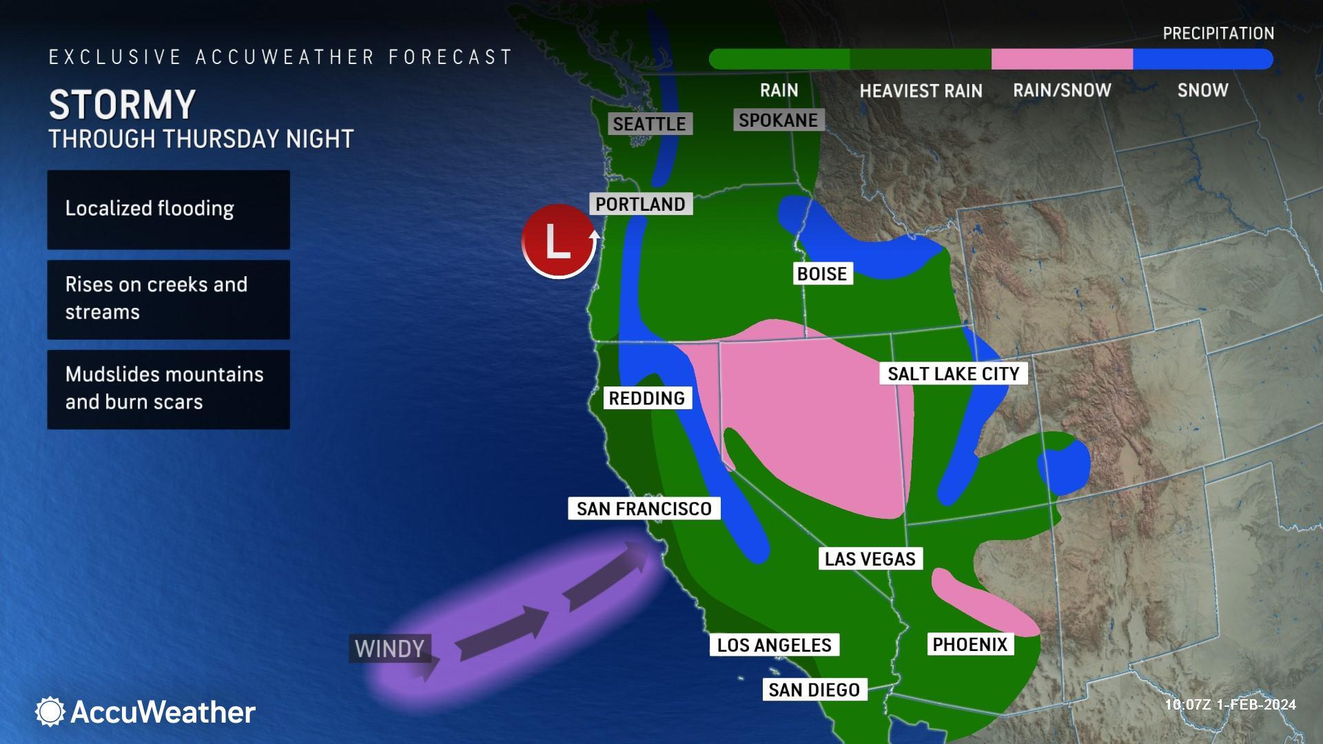
As the first storm swings southward, snow levels will lower from north to south across the southern Cascades and Sierra Nevada. Motorists will encounter difficult travel over Donner Pass, California, as snow continues through Thursday night before tapering to snow showers on Friday.
A general 1-2 feet of snow will fall on the intermediate elevations and most passes of the Sierra Nevada, with 2-4 feet likely at some of the resorts and most ridges and peaks into Friday.
"By the time it gets cold enough for snow over the passes in Southern California late Thursday night to Friday morning, much of the storm's moisture will be fleeting," AccuWeather Senior Meteorologist John Feerick said. "However, there may be some slippery spots over the crest of the passes along Interstate 5 and 15."
Rain, mountain snow from 1st storm to push inland Friday and Saturday
As drier air causes rain and mountain snow to diminish and become more showery later Thursday night and Friday over much of California, areas of rain and mountain snow will spread from Arizona to Montana from Friday to the weekend.
Motorists may encounter slushy and slippery conditions along stretches of Interstate 15 in Utah and Idaho, with conditions ranging from wet and slushy to snow-packed along Interstates 25, 70 and 80.
Snow around the Denver metro area from Friday night through Saturday will range from a slushy coating around the airport to the east to a general 6-12 inches over the Rockies to the west, where an AccuWeather Local StormMax™ of 30 inches is most likely to occur. Motorists should anticipate slow travel, while airline delays are likely due to deicing operations.
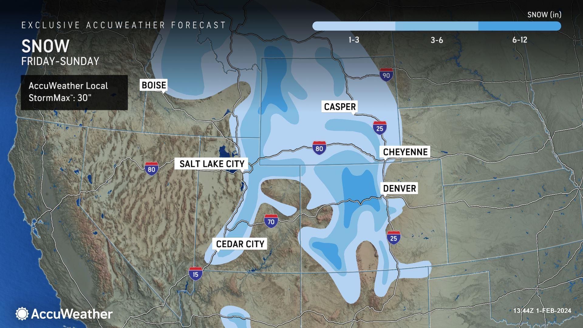
The same storm will transfer much of its energy and moisture toward the Gulf Coast region this weekend with areas of flooding rain and severe thunderstorms.
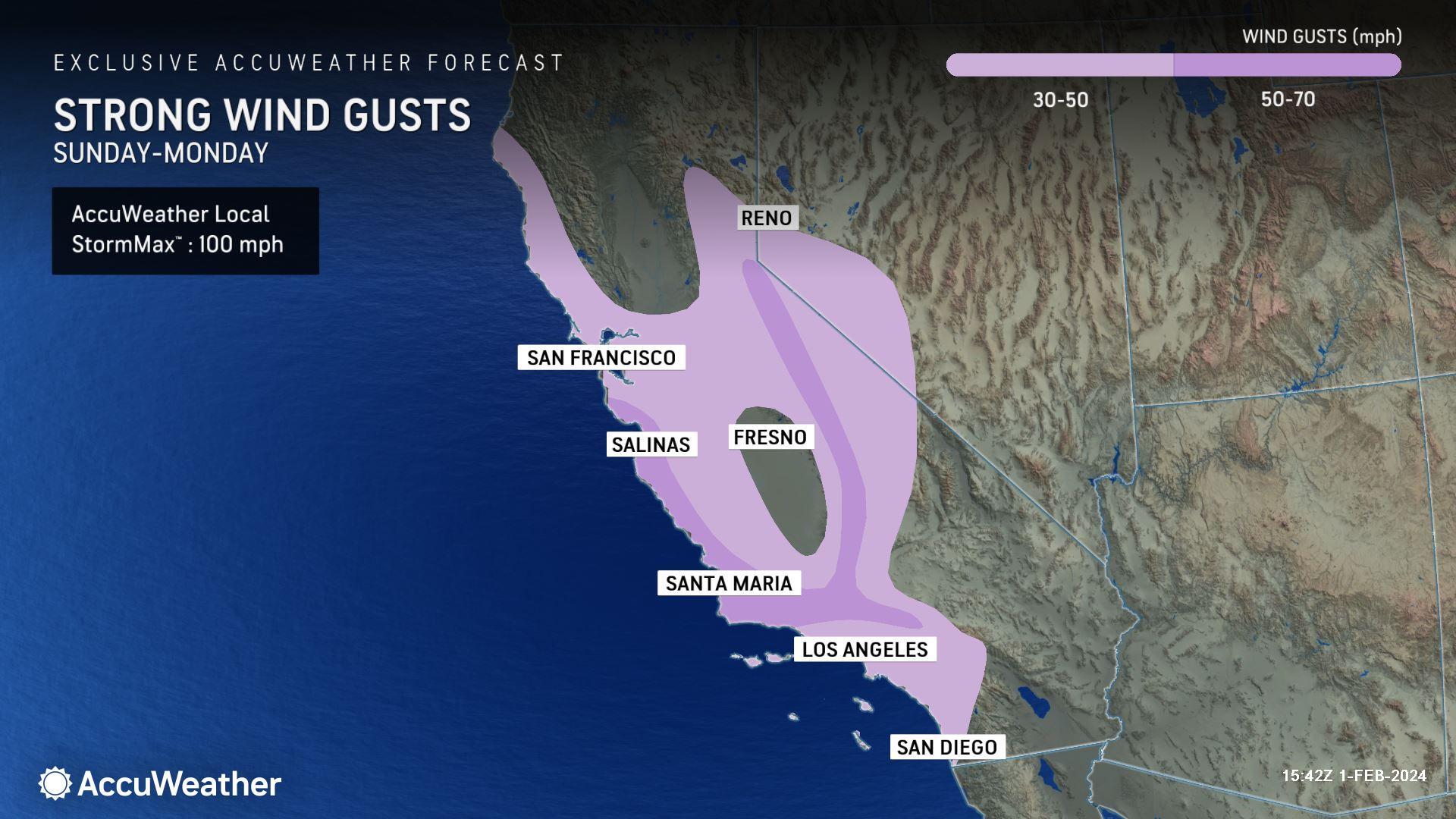
2nd major storm to roll into California Sunday and Monday
Hot on the heels of the first storm, a second and perhaps equally as potent storm will roll in from the Pacific during the latter part of the weekend.
"The second storm originated from near Hawaii and is likely to have a true plume of tropical moisture associated with it," AccuWeather Senior Meteorologist Dan Pydynowski said.
This Pineapple Express may focus its heaviest rain from near San Francisco to just north of Los Angeles, where several inches may pour down over a couple of days. Once again, locally higher amounts are likely over the west- and southwest-facing slopes of the Coast Ranges. However, drenching rain will still fall on much of Southern and Northern California and southern Oregon.
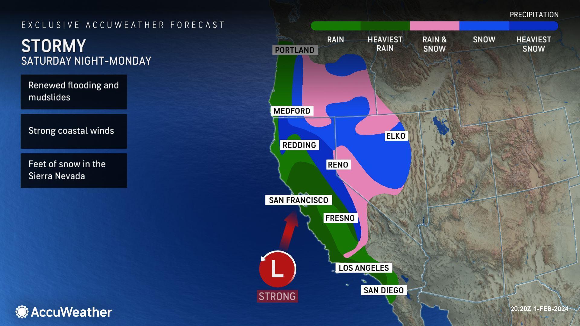
Even heavier snow may fall on the Sierra Nevada when compared to the last storm, as the plume of moisture may linger longer than the first. This means that some major roads may close for a time and secondary roads could become blocked with snow for days.
Because of the second storm's rapid-fire nature-- coming only a couple of days after the first storm soaked and blanketed the state-- travel and flooding problems from the second storm may be more extensive and much worse than those from the first storm. Expect major urban and small stream flash flooding as well as significant rises on some of the larger rivers in the region with flooding in unprotected areas.
The second storm and its slower-moving atmospheric river may unload two times the amount of rain or more on Central and Southern California compared to the first storm.

The second storm may cause trouble for travelers heading home from weekend ventures and for businesses and schools at the start of the new week.
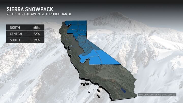
Storm duo to boost seasonal rainfall, snowfall totals
The combination of snow from both storms spanning the middle of this week to early next week may deliver 5-10 feet of fresh snow on the high country of the Sierra Nevada. The anticipated snowfall should put the Sierra snowpack back on track and then some for the winter.
Rainfall from the two storms will push totals since the start of the rainy season in early October to well above the historical average in many cases. Downtown Los Angeles could come close to doubling its pre-storm total of 5.23 inches from Tuesday in less than a week. Rainfall in San Francisco could surpass 15 inches from Oct. 1.


