AccuWeather meteorologists are available 24/7 to provide further insights and updates on evolving weather conditions. Please contact pr@accuweather.com during regular business hours, or support@accuweather.com or call AccuWeather’s Media Hotline at (814)-235-8710 at any time to arrange interviews with AccuWeather experts or to request the most updated graphics for print or broadcast.
Major Hurricane Landfall Expected along Gulf Coast on Thursday
Sept. 23, 2024
>>> Watch Monday’s Zoom Media Briefing
Passcode: WXVxb8K$
>>> Register to join Live Zoom Media Briefing + Q&A with AccuWeather Lead Hurricane Expert Alex DaSilva Tuesday at 8:30am EDT / 7:30 CDT
|
> AccuWeather Local StormMax™ of 160-mph wind gusts and 24” of rainfall possible in the hardest-hit areas
> Potential that this storm could intensify into a Category 4 hurricane with maximum sustained winds of 130-156 mph on the Saffir-Simpson Hurricane Wind Scale
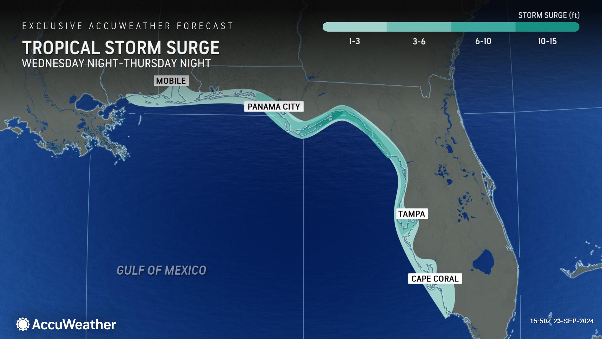
> Risk of 3-6 feet of storm surge in Tampa Bay area and up to 10-15 feet of storm surge in the area where the storm makes landfall |
|||
AccuWeather Global Weather Center – Sept. 23, 2024

“This is expected to be a large hurricane with a major storm surge threat and impacts that will reach hundreds of miles inland from where this storm makes landfall,” said AccuWeather Chief Meteorologist Jon Porter. “We expect significant flooding problems that could reach as far inland as Atlanta and potentially a secondary area of significant flooding in the southern Appalachians.”
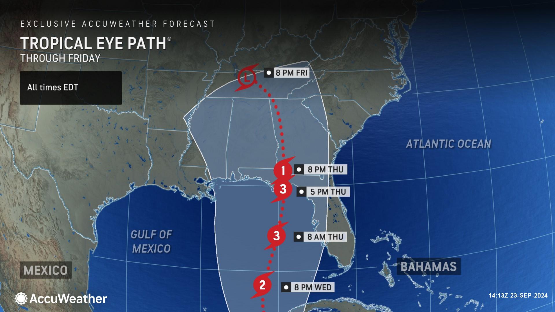
AccuWeather is forecasting a powerful Category 3 hurricane with maximum sustained wind gusts of 111-130 miles per hour to make landfall along the U.S. Gulf coast on Thursday. AccuWeather Lead Hurricane Expert Alex DaSilva said people along the Gulf coast from southwestern Florida to Louisiana need to closely monitor AccuWeather forecast updates.
“People on both the eastern and western sides of our forecast cone need to be prepared. Everyone in the Tampa Bay region should be ready for storm surge impacts, even if this storm stays well offshore,” said DaSilva “We’re closely monitoring a dip in the jet stream that is expected to cross over the Mississippi Valley this week. If it’s a bit stronger and plunges farther south than what we are currently forecasting, it could pull the storm farther west toward Biloxi and Mobile. If the jet stream ends up being faster and a bit weaker, it could steer the storm farther east toward the Big Bend region of Florida.”
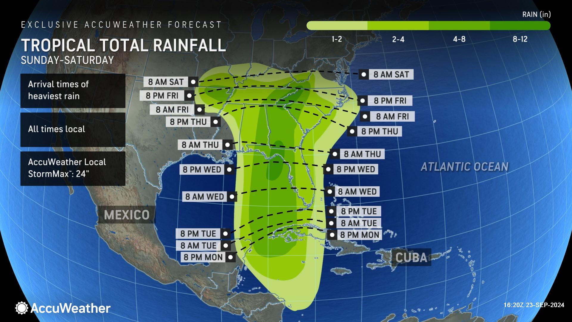
AccuWeather expert meteorologists are forecasting 8-12 inches of rainfall near the point of landfall, as well as an area in the southern Appalachians, with an AccuWeather Local StormMax™ of 24 inches. This heavy rain can lead to widespread flooding near the center of the storm track, which can cause extensive flooding and standing water for days. Travel delays and impacts are expected in the region. AccuWeather is forecasting 500 flight cancellations on Thursday and 1,000 flight cancellations on Friday. Flooding impacts could reach as far inland as the Ohio River Valley. The storm will also impact the cruise industry in the region and other offshore activities, including eastern energy platforms.
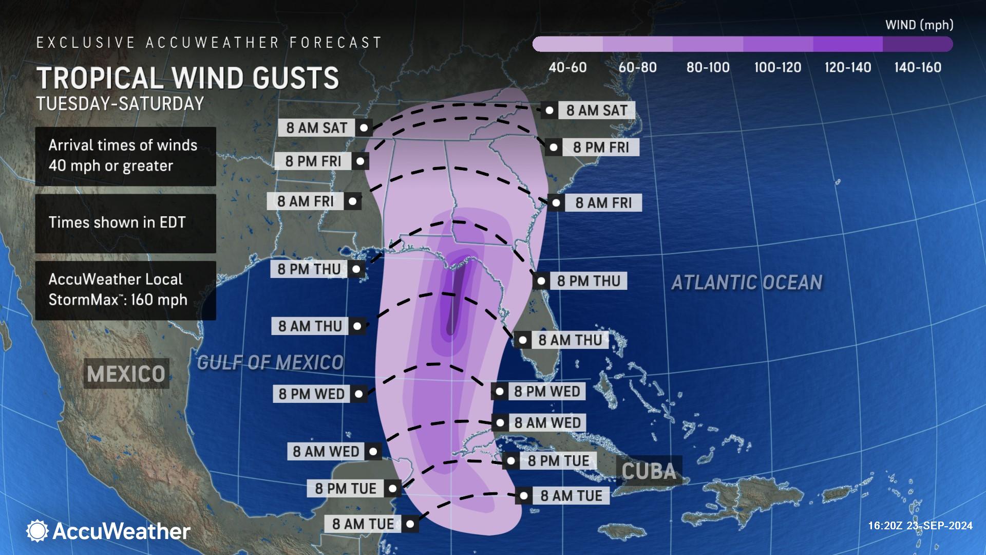
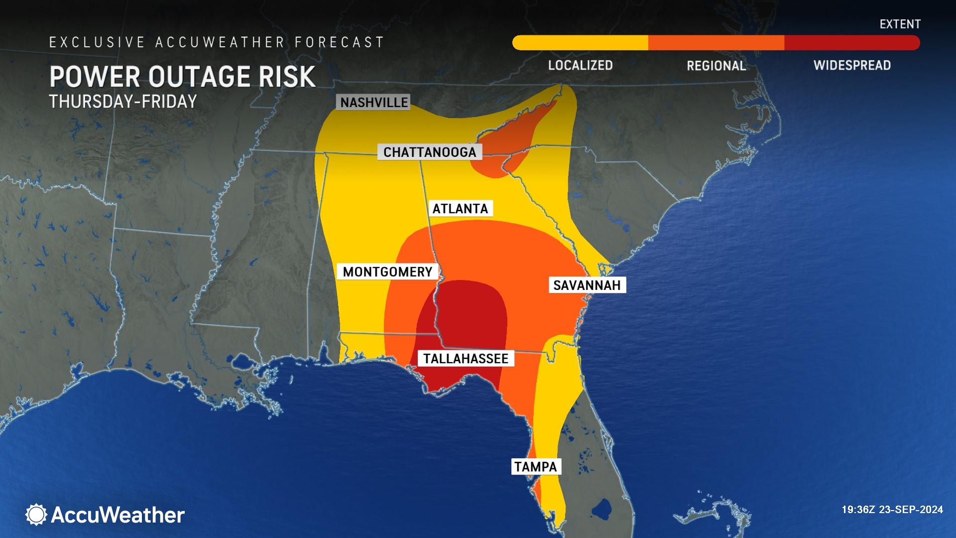
Wind gusts of 60-80 mph are forecast across the Florida Panhandle, as well as across southern Georgia and Alabama. Near where the center of circulation makes landfall, wind gusts can reach 140-150 mph with an AccuWeather Local StormMax™ of 160 mph. These winds can cause significant structural damage near landfall and bring power outages that may last for weeks and damage or destroy buildings in its path. Winds of this magnitude take debris and send it flying into other objects, amplifying damage.
AccuWeather expert meteorologists say people from Mobile, Alabama, to Fort Myers, Florida, should prepare for the potential of 1-3 feet of storm surge Wednesday night through Thursday night. Areas from Panama Beach, Florida, to the Tampa Bay area will have 3-6 feet of storm surge. A 6- to 10-foot surge in Florida's Big Bend can be life-threatening. A storm surge of 10-15 feet is possible east of Apalachicola, Florida.
“This is going to be a life-threatening storm with dangerous storm surge,” said Rayno. “The one factor that is alarming is how incredibly high water temperatures are, which can fuel rapid intensification right along the forecast track of this storm.”
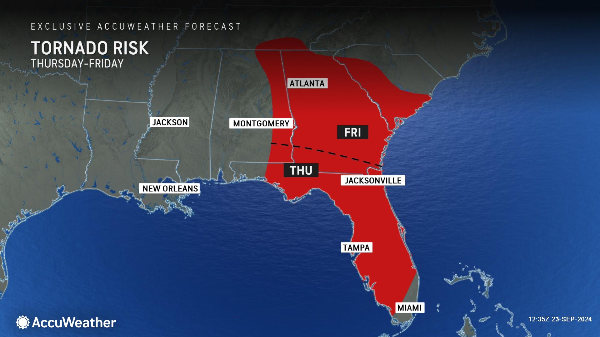
AccuWeather expert meteorologists say there will also be a risk of spin-up tornadoes as the storm approaches the coast and moves inland through Friday night, mainly to the north and east of the storm track.
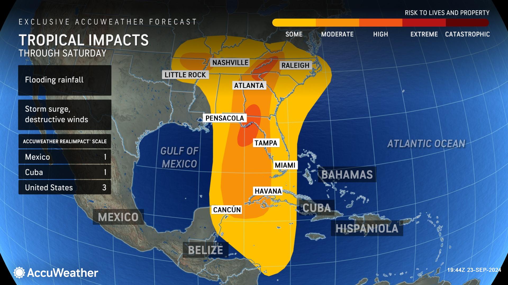
Due to impacts from dangerous flooding rainfall, strong winds and storm surge and the total damage and economic impact this storm is expected to bring, this wind and rainstorm is a 3 for United States on the AccuWeather RealImpact™ Scale for Hurricanes, which warns of widespread and substantial flooding, structural damage to buildings, especially mobile homes, as well as downed trees, power outages and major coastal inundation.
In contrast to the Saffir-Simpson scale, which classifies storms by wind speed only, the AccuWeather RealImpact™ Scale is based on a broad range of important factors. In order to better communicate a more comprehensive representation of the potential impact of a storm on lives and livelihoods, the scale covers not only wind speed but also flooding rain, storm surge and economic damage and loss. Some of these hazards, such as inland flooding and storm surge in many storms, result in more deaths and economic loss than wind.
AccuWeather was the first known source to issue a track and intensity forecast for this hurricane threat on Sunday afternoon, more than 16 hours before the National Hurricane Center issued its first track.
“We’ve been sounding the alarm about the growing threat of homegrown development for more than a week. Storms that develop close to the United States give people less time to prepare, compared to a storm that forms in the open Atlantic and takes more than a week to approach the United States,” said Rayno. “There is only one factor that could prevent this storm from exploding. There’s a lot of dry air over the Gulf of Mexico, but we expect this storm to create its own environment to grow and thrive.”
Porter explained that this hurricane threat is expected to overcome environmental obstacles that other storms struggled with this season.
“There is a lot of mid-level dry air that the storm will need to overcome, but we think it will be able to do that because it creates its own environment with abundant moisture. Some hurricanes can develop their own moist pocket around the storm to essentially sustain themselves, even though there’s a lot of dry air to the north,” Porter explained. “This developing storm will track through an area that has very warm waters that reach hundreds of feet deep. Wind, rain and storm surge impacts are expected to spread well beyond the center of the forecast track. We expect this to be a very large and powerful hurricane.”
AccuWeather Forecast Graphics
Additional AccuWeather Resources:
Hurricane to intensify over Gulf of Mexico, to be strongest to strike US this season
Hurricane Tracking & Storm Radar
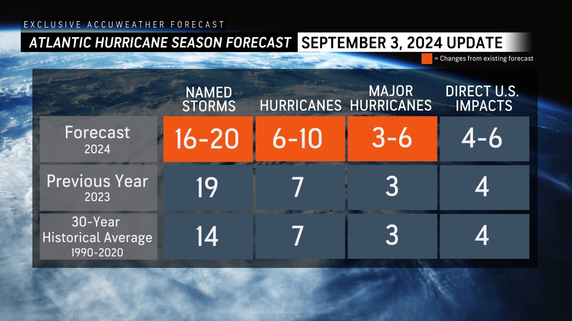
AccuWeather Reduces Forecast for Number of Named Storms and Hurricanes During 2024 Atlantic Hurricane Season
Rapidly Intensifying Hurricanes Near Coastline Pose Major Threat To US This Season


