


AccuWeather meteorologists are available 24/7 to provide further insights and updates on evolving weather conditions. Please contact pr@accuweather.com during regular business hours, or support@accuweather.com or call AccuWeather’s Media Hotline at (814)-235-8710 at any time to arrange interviews with AccuWeather experts or to request the most updated graphics for print or broadcast.
Strengthening storm to blast the Northeast with rain and snow; major cooldown for the Southeast
Nov. 20, 2024

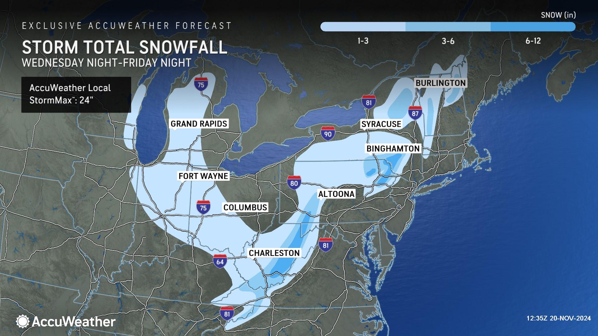
> 6-12 inches of snow is expected in the higher elevations of Pennsylvania, New York, Maryland and West Virginia, with an AccuWeather Local StormMax™ of 24 inches
> Snow and freezing temperatures are expected in some mountain towns impacted by Helene in the southern Appalachians
> Temperatures could drop 5-15 degrees below the historical average across much of Florida and the Southeast through Friday
AccuWeather Global Weather Center – Nov. 20, 2024
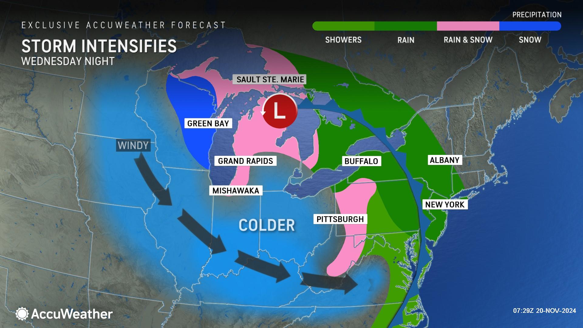
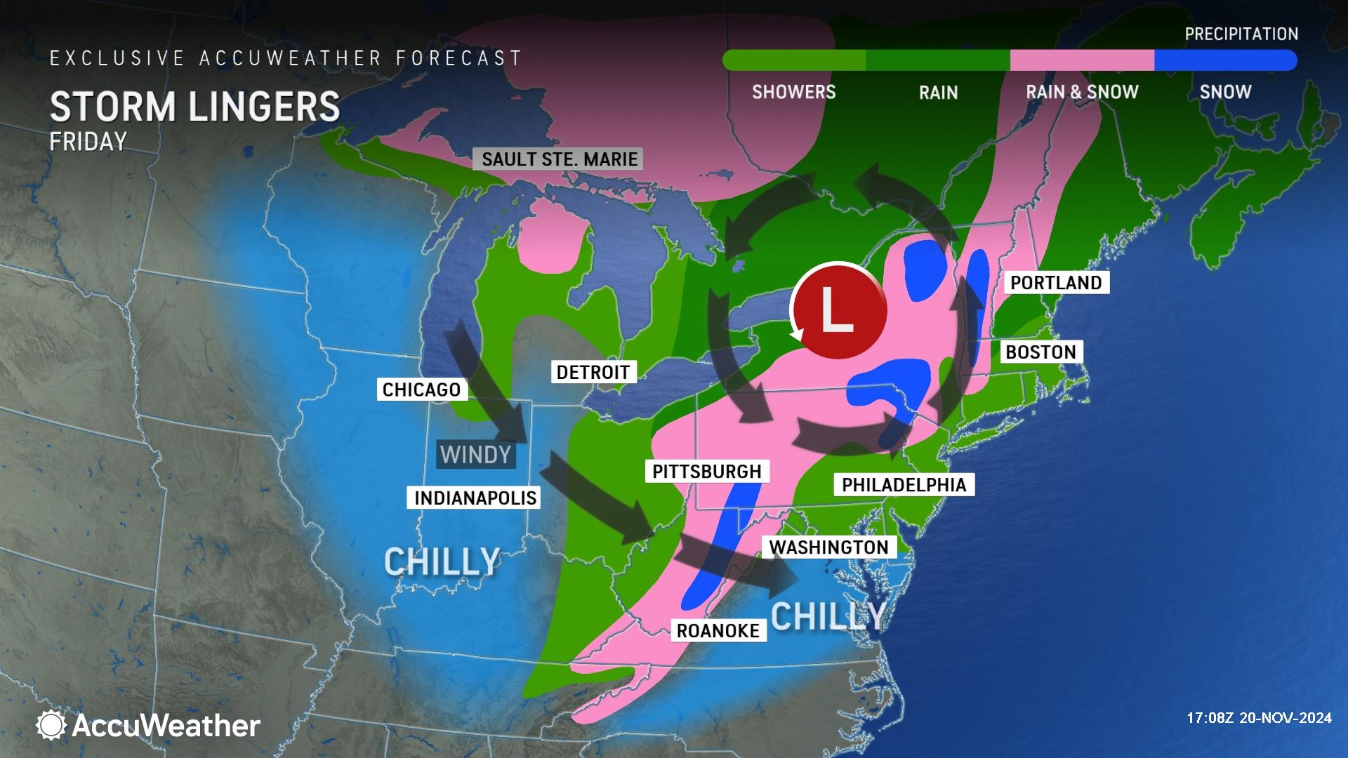
A strengthening storm over the Great Lakes is expected to bring a wintry blast to parts of the Northeast, New England and the Appalachians, with freezing temperatures and the first accumulating snowfall of the season for some in the region.
“There could be a foot or more of heavy wet snow in some of the mountains. The Poconos could look like a snow globe,” said AccuWeather Chief On-Air Meteorologist Bernie Rayno. “Before the snow arrives, we’ll see some much-needed rain to help with the brush fires and drought conditions.”
AccuWeather expert meteorologists say the storm will help bring the coldest air of the season so far to the Northeast. Rain will shift from the Appalachians to the mid-Atlantic coast from late Wednesday into Thursday.
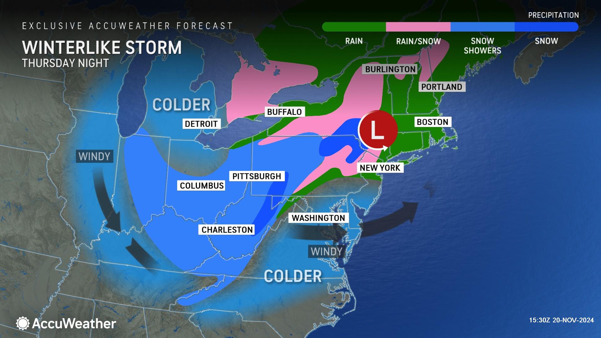
On Friday, another day of rain and wind is expected in parts of New England and upstate New York. Meanwhile, chillier air that arrived with the storm farther west across the interior will result in a mix of rain and snow.
"There is the potential for a foot or more of snow to fall over the ridges, plateaus and peaks in the mountains of West Virginia, western Maryland and western Pennsylvania," said AccuWeather Senior Meteorologist Dan Pydynowski. "Some locations with elevations near and above 2,000 feet can easily end up with a foot or more of snow.”
A few pockets or bands will exist where the lake effect enhances the snowfall rate enough to overcome the warm ground and above-freezing air to bring some accumulation. This can extend southward to the Tennessee and North Carolina mountains.
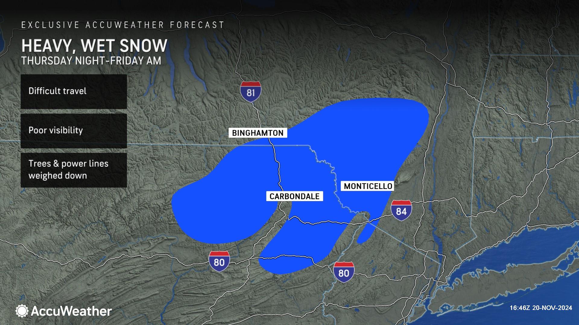
Another heavy snow zone may develop as the storm evolves from Friday to Saturday. Pockets of moderate snow with 3-6 inches of accumulation are likely with heavier snow possible in the Poconos, Catskills, Adirondacks and the Green and White Mountains.
“It’s going to start thumping snow Thursday night into Friday. A frontal boundary will move offshore with the first storm. A second storm moving eastward with colder air will interact with the backside of moisture wrapping around the first storm off the coast,” Rayno explained. “Heavier snow could reach down into the mountains of West Virginia. This is an exciting treat for the ski mountains heading into the holiday season.”
AccuWeather Lead Hurricane Expert Alex DaSilva says the wintry blast could impact mountain towns in North Carolina and Tennessee that were left devastated by catastrophic flooding and wind damage from Helene nearly two months ago.
“This will be a difficult week for families living in campers and tents after Helene. One of the hardest-hit towns is Swannanoa, North Carolina. People in towns like Swannanoa could be dealing with a few inches of snow and freezing temperatures overnight,” DaSilva said. “This could be a tough winter for families in towns left devastated by Helene. It can be a challenge to stay warm and prevent water lines from freezing in temporary housing.”
AccuWeather expert meteorologists say a major cooldown will bring the chilliest air of the season to much of the Southeast and Florida on Thursday and Friday.
Temperatures could drop 5-15 degrees below the historical average by the end of the week. Humidity levels will be drastically slashed in parts of the Southeast and Florida in the wake of Tropical Rainstorm Sara.
AccuWeather Forecast Graphics

Additional AccuWeather Resources:
Taste of winter: Storm to deliver snow, rain and wind to Midwest, Northeast
Thanksgiving forecast: Weather could complicate travel for millions
Winter forecast for the US in the 2024-25 season


