


AccuWeather meteorologists are available 24/7 to provide further insights and updates on evolving weather conditions. Please contact pr@accuweather.com during regular business hours, or support@accuweather.com or call AccuWeather’s Media Hotline at (814)-235-8710 at any time to arrange interviews with AccuWeather experts or to request the most updated graphics for print or broadcast.
Tropical Rainstorm Takes Aim at Mexico & South Texas; Second Threat Brewing Off Florida’s East Coast
June 17, 2024

> Forecasters warn of dangerous flash flooding, travel delays, and rip current
risks along the Gulf of Mexico from southern Texas to Louisiana

> Second potential tropical threat in the Atlantic expected to bring downpours
to parts of eastern Florida, Georgia, and South Carolina

> The first tropical threat that strengthens to a Tropical Storm will be
named ‘Alberto’
AccuWeather Global Weather Center – June 17, 2024
AccuWeather expert meteorologists have issued a Forecast Eye Path® for a tropical rainstorm in the southern Gulf of Mexico that is expected to bring torrential rain and flooding to parts of southern Texas and northeastern Mexico this week.
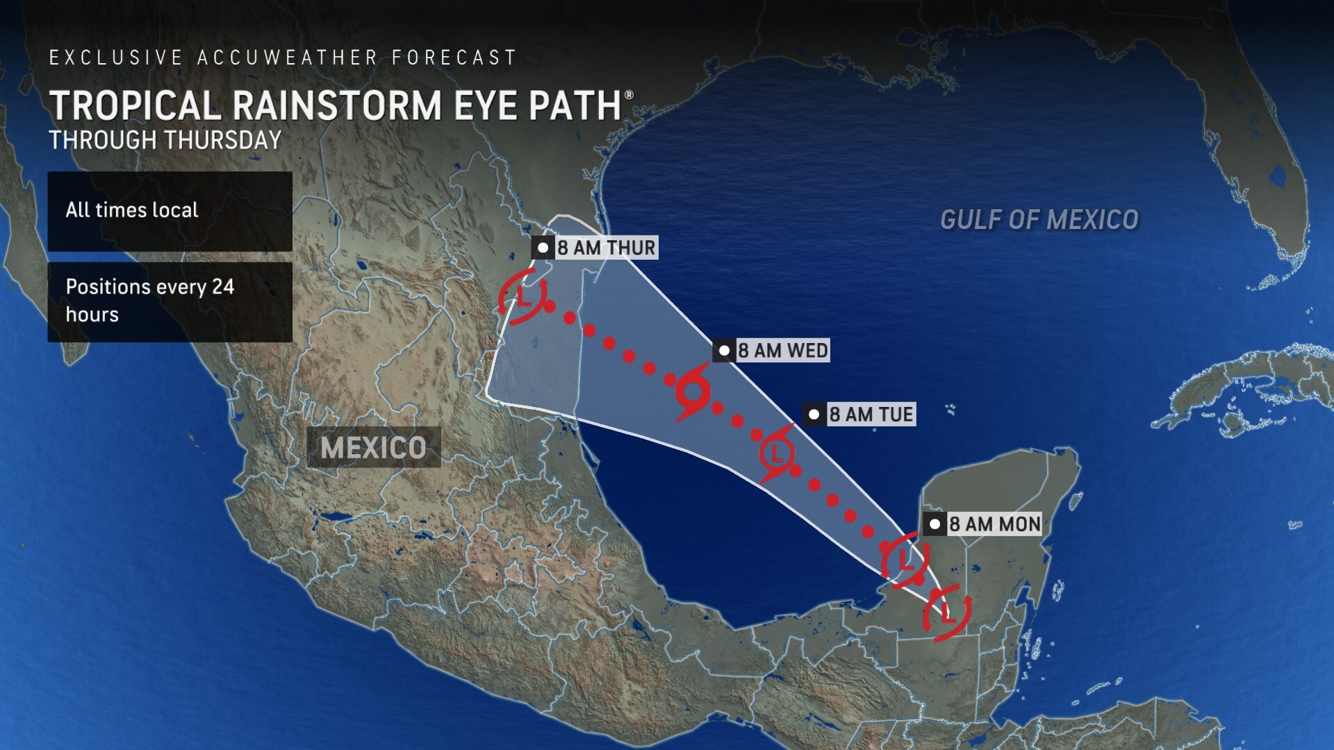
This tropical rainstorm is forecast to strengthen to a tropical depression, then a tropical storm, shortly before making landfall along the northern Gulf Coast of Mexico.
If the tropical rainstorm strengthens to have maximum sustained winds of at least 39 mph, it will be named Tropical Storm Alberto.
Given the limited time over water and close proximity to land, AccuWeather expert meteorologists say this storm will need to intensify quickly in order to reach tropical storm strength before landfall.
“This tropical rainstorm should move over the Bay of Campeche and start to strengthen Tuesday,” said AccuWeather Lead Hurricane Forecaster Alex DaSilva. “It doesn’t have too much time before it eventually makes landfall in northern Mexico, or possibly in extreme southern Texas Thursday morning.”
DaSilva says conditions in the Bay of Campeche and the southern Gulf of Mexico are nearly ideal for tropical development.
AccuWeather expert meteorologists first issued a high risk for potential tropical development in the southern Gulf of Mexico on June 13.
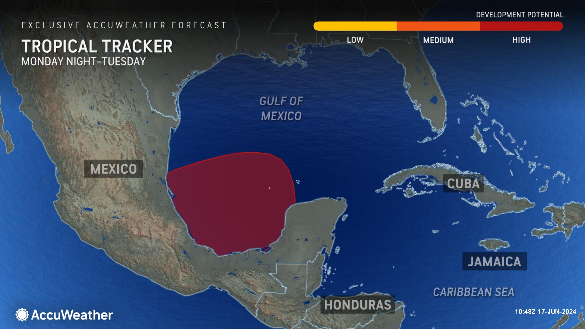
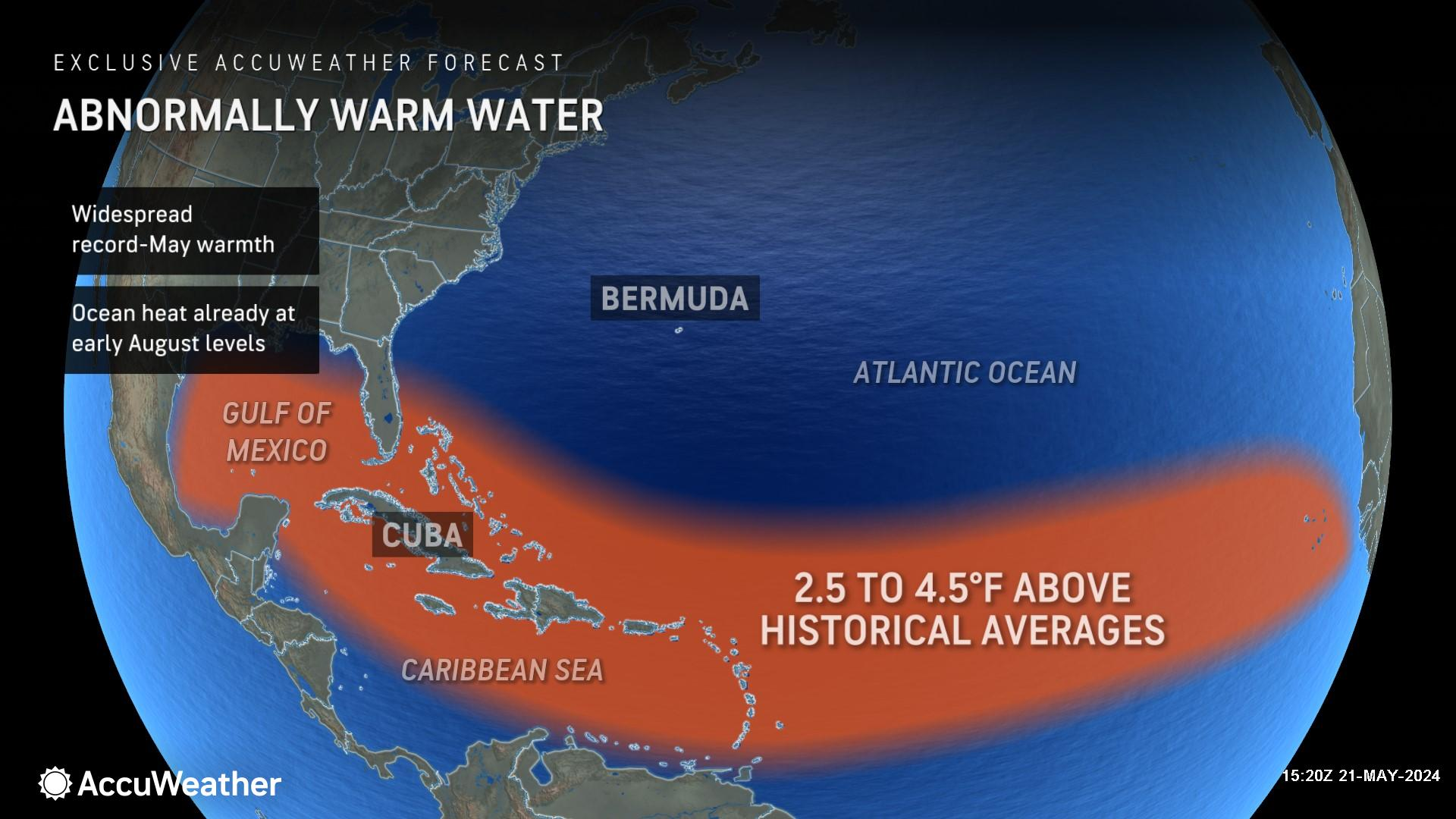
“Water temperatures are very impressive. It’s basically bathtub water across most of the Atlantic Basin, and it’s just going to continue to get warmer,” said DaSilva. “That area and coastline is shaped like a bowl, that can actually help to induce spin. We have seen a lot of tropical development in that area over the years.”
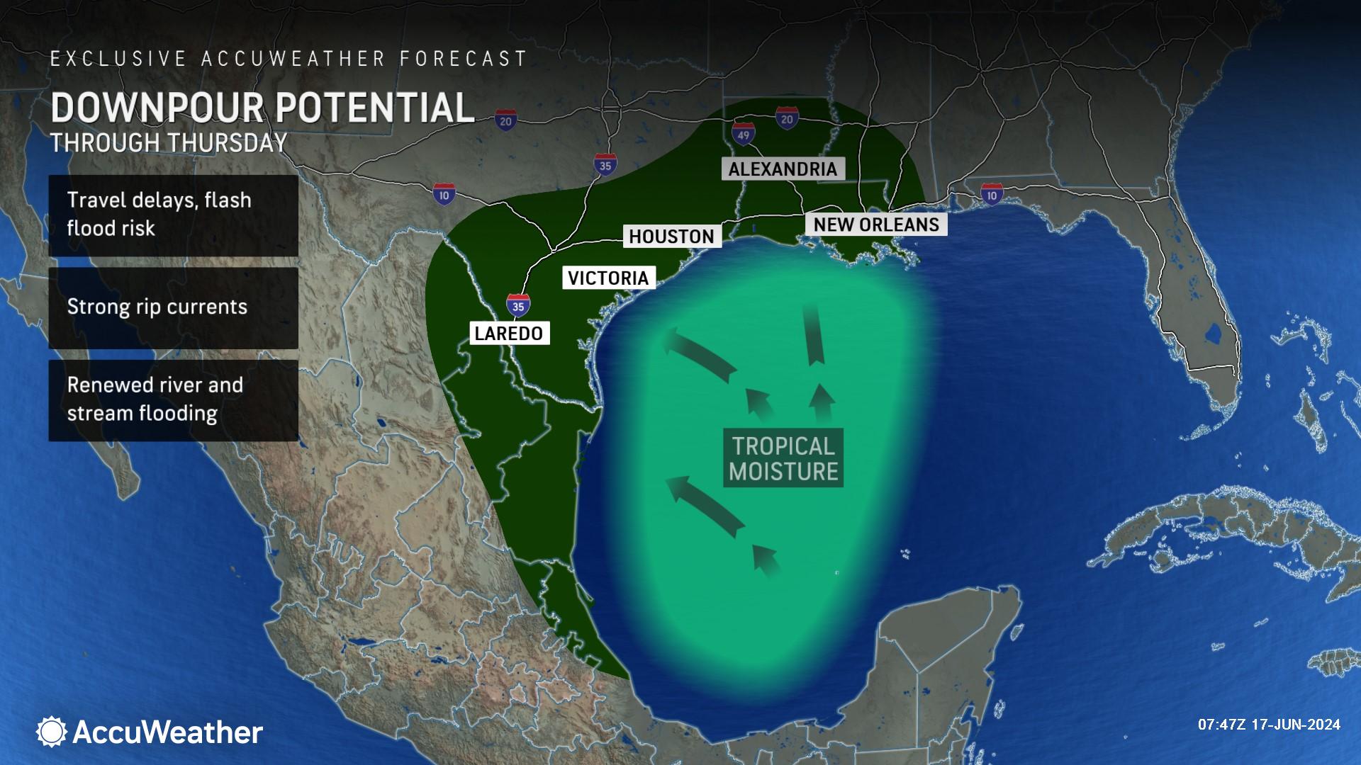
Flooding Threat Along The Gulf Coast
AccuWeather expert meteorologists say this tropical rainstorm will bring flooding downpours to parts of Mexico, Texas, and parts of Louisiana.
“Regardless of whether this system becomes a tropical storm and is named, the impacts will be similar. Flooding downpours looks to be the main concern,” said DaSilva. “June 20 is typically when we see our first named storm in the Atlantic basin, so if this develops in the Bay of Campeche, we will be right on schedule according to historical averages.”
AccuWeather expert meteorologists say the heaviest rainfall from the tropical rainstorm will arrive across coastal Texas and Louisiana on Tuesday.
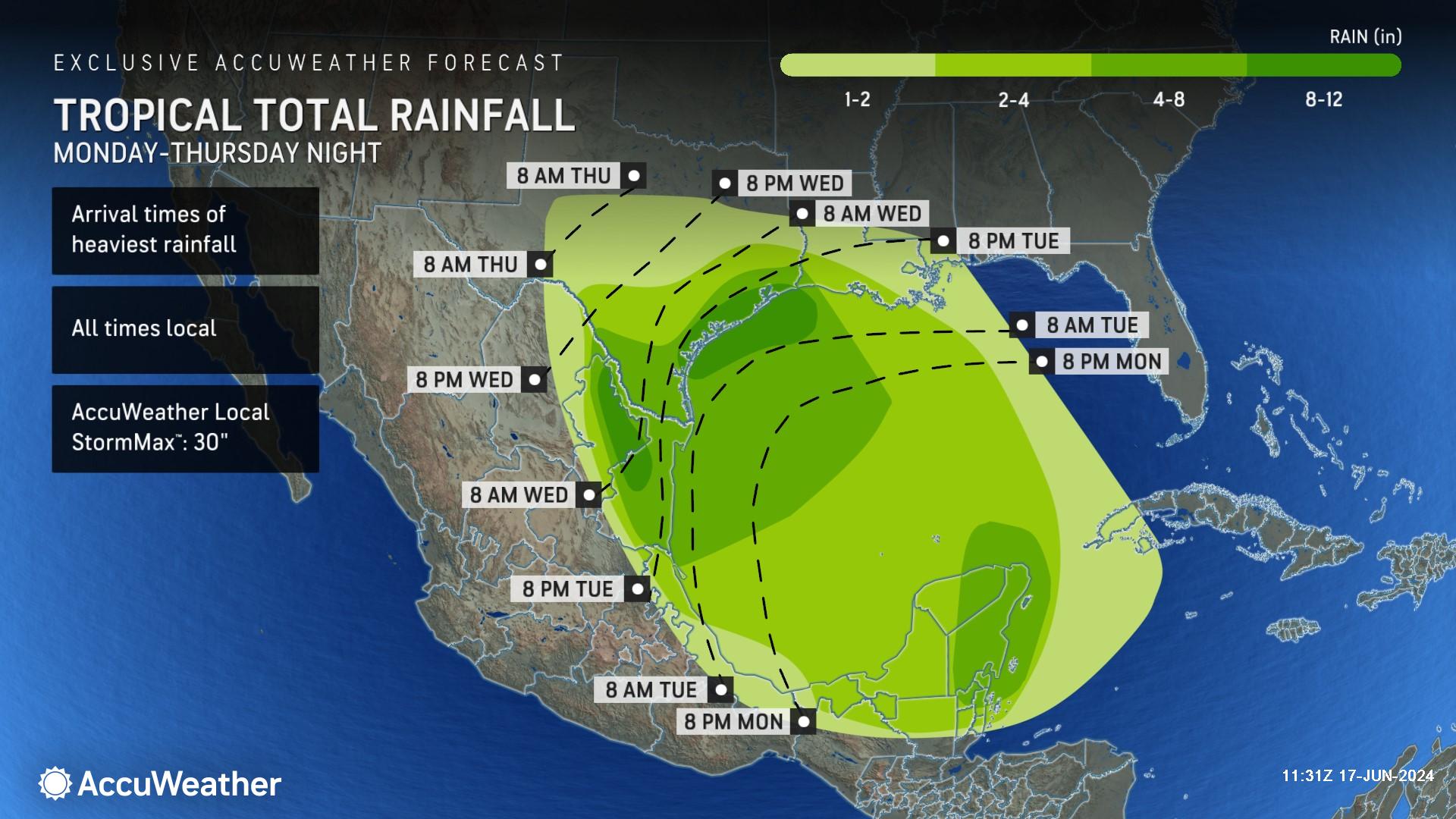
Much of coastal southeastern Texas, including Houston, Galveston, and Beaumont, could see 8 to 12 inches of rain this week. The mountains of northeast Mexico could also experience 8 to 12 inches of rain.
Areas hit hardest by flooding rains in Mexico and Texas could see up to 30 inches of rain this week, according to the AccuWeather Local StormMax™.
AccuWeather expert meteorologists forecast this tropical rainstorm to be a 1 on the AccuWeather RealImpact™ Scale for the United States and Mexico.
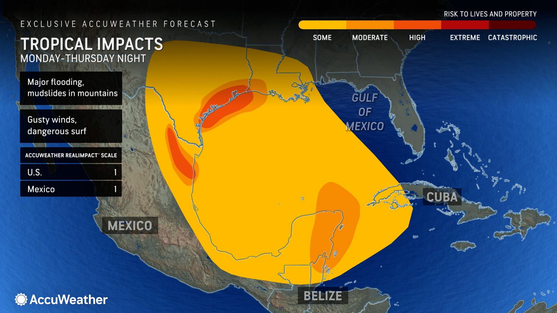
An AccuWeather RealImpact™ Scale of 1 warns of localized flooding, damage to unanchored mobile homes, vegetation, localized power outages, and coastal inundation resulting in some property damage.
Unlike the Saffir-Simpson Hurricane Wind Scale, which only factors in wind speed, the AccuWeather RealImpact™ Scale factors in storm surge, flooding rain, wind, and total economic damage and loss.
River Flooding Possible
River levels along the Sabine, Trinity, and Neches rivers east of Houston are still in moderate and minor flood stage, following rounds of heavy rainfall and flooding in eastern Texas last month.
Any downpours from the tropical rainstorm that reach eastern Texas this week could renew flooding risks along rivers and streams that are still swollen from last month’s storms.
The Trinity River near Liberty, Texas is currently in moderate flood stage and is forecast to rise nearly one foot to major flood stage on Thursday.
People should avoid walking or driving through flooded areas. It only takes six inches of moving water to knock a person off their feet and only 12 inches of moving water to lift a vehicle and carry it away.
All contact with flood waters should be avoided. AccuWeather expert meteorologists say flood waters can carry harmful bacteria, chemicals, and can limit visibility of other hazards like downed power lines, debris, animals, or missing manhole covers.
AccuWeather expert meteorologists say 40 to 60 mph wind gusts from the tropical rainstorm are possible in coastal areas of northern Mexico.
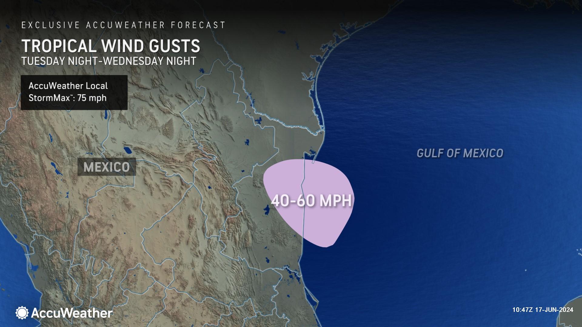
Gusts up to 75 mph are possible, according to the AccuWeather Local StormMax™.
Repeat Risk Of Tropical Trouble In The Gulf
AccuWeather expert meteorologists say it’s not out of the question that another tropical threat could develop near the Yucatan Peninsula of Mexico later this week.
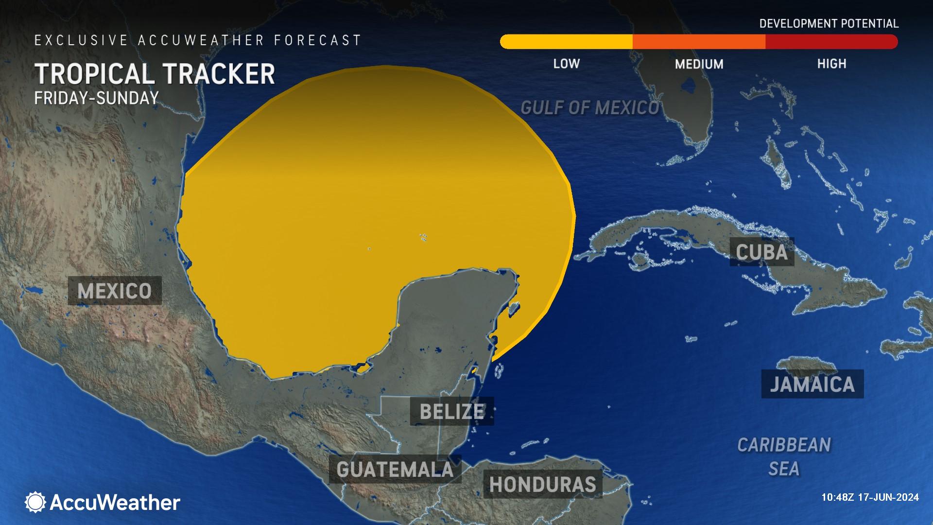
"With warm waters and low wind shear still present in the southern Gulf of Mexico and northwestern Caribbean this coming weekend, yet another opportunity for tropical development may present itself," said AccuWeather Senior Meteorologist Dan Pydynowski.
Southeast Atlantic Coast On Alert For Development
AccuWeather expert meteorologists have issued a low risk of potential tropical development along the eastern coast of Florida and parts of the Bahamas from Tuesday through Thursday.
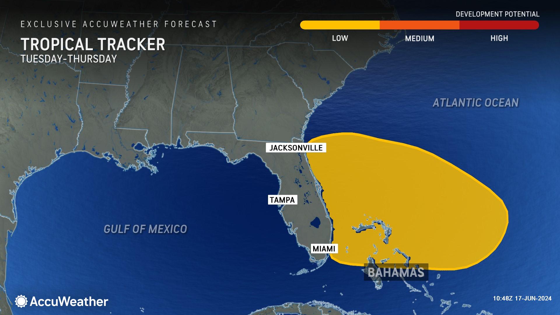
"This appears to be a quick-moving and compact storm that will be moving westward into northeastern Florida or perhaps as far north as southeastern Georgia on Thursday," said Pydynowski.
A stronger storm could bring gusty winds to coastal locations, but even a less-organized storm would bring rough surf and downpours from the northern Bahamas to the Southeast Atlantic Coast.
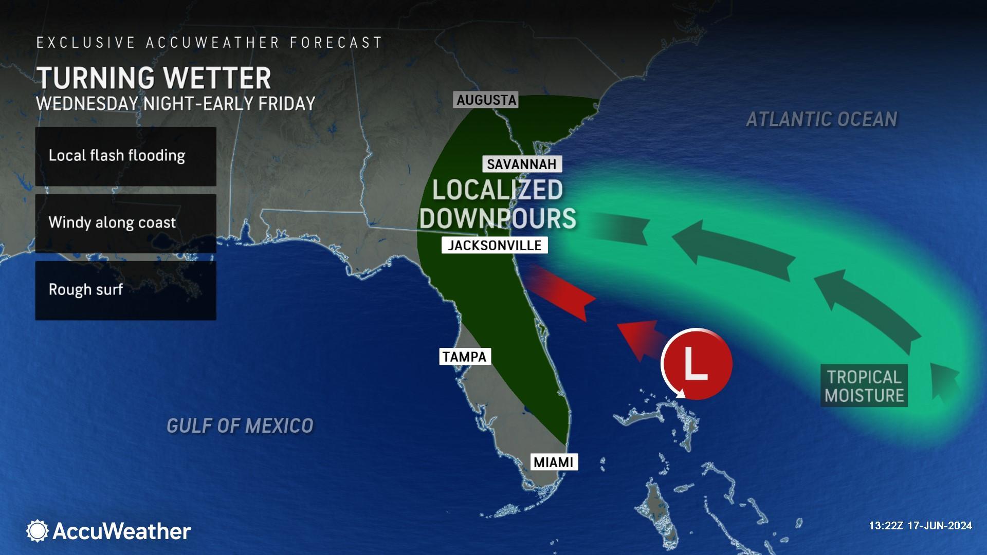
Heavy tropical rainfall may impact some of the same areas that were drenched by last week's tropical rainstorm. The highest rainfall totals are likely to miss Miami, which saw more than 11 inches of rain last week.
AccuWeather expert meteorologists say Melbourne, Florida, to Charleston, South Carolina face the greatest risk of heavy rain and rough surf.
The zone currently primed for the heaviest rain has had very little rain so far this month, including Jacksonville, Florida, which only has reported 0.64 of an inch of rainfall.
‘Explosive’ Hurricane Season Ahead
This tropical threat for southern Texas and northeastern Mexico is just the start of what is expected to be a long and impactful hurricane season.
Following widespread flooding in southern Florida from a tropical rainstorm last week, DaSilva says it’s important for everyone along the Atlantic and Gulf coasts to be prepared for hurricane season impacts, and to avoid driving down flooded streets.
Water is the deadliest threat during hurricane season, not the wind. Drownings in flooding from rainfall, storm surge, and rough surf account for roughly 90 percent of all fatalities in tropical storms and hurricanes.
AccuWeather expert meteorologists and long-range forecasters first warned the public in March, ahead of other sources, of the early warning signs and clear indicators of an ‘explosive’ hurricane season on the horizon.
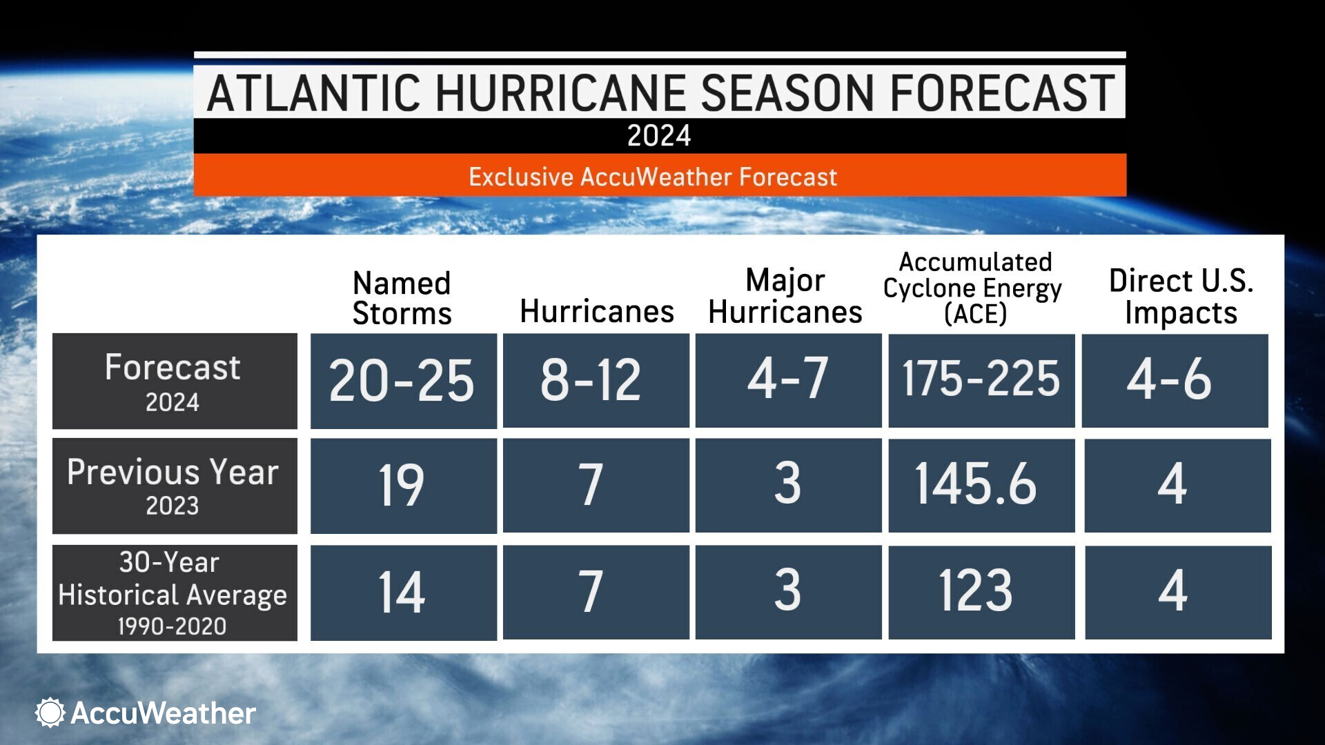
AccuWeather is forecasting 4 to 6 direct impacts to the United States this hurricane season.
DaSilva says warm water temperatures at the surface and hundreds of feet deep, the shift to a La Niña pattern this summer, and the forecasted reduction of wind shear all contribute to favorable conditions for storms to develop and intensify across much of the Atlantic Basin.
“Water temperatures in parts of the Gulf of Mexico are what we would expect to see in early August, and we’re only in mid-June. We’re well ahead of historical averages. This is very concerning as we move deeper into hurricane season,” warned DaSilva. “Warm waters can act like jet fuel, helping storms develop and intensify. Last year was the warmest season on record in terms of sea surface temperatures in the Atlantic Basin. Right now, we are outpacing 2023.”
AccuWeather long-range forecasters issued an alert in May warning families, businesses, and government leaders to prepare for the growing threat of rapidly intensifying storms near the coast this season.
Storms that rapidly intensify near coastal cities will leave people with less time to react and prepare, potentially leaving officials with less time to activate emergency plans and coordinate evacuations.
AccuWeather expert meteorologists encourage people to have emergency kits prepared and to review your local evacuation zones and routes, which may have changed since last year’s hurricane season.
Additional AccuWeather Resources:
Tropical rainstorm to bring deluge of rain to Texas, Louisiana
AccuWeather RealImpact™ Scale
What to do when a flash flood hits
What is wind shear and how does it impact hurricanes, other tropical cyclones?
AccuWeather Forecasts Explosive 2024 Hurricane Season
Hurricane season: AccuWeather's guide for first-timers


