


AccuWeather meteorologists are available 24/7 to provide further insights and updates on evolving weather conditions. Please contact pr@accuweather.com during regular business hours, or support@accuweather.com or call AccuWeather’s Media Hotline at (814)-235-8710 at any time to arrange interviews with AccuWeather experts or to request the most updated graphics for print or broadcast.
Hurricane Beryl Could Make Landfall on Jamaica; Growing Risk of Some Impact to Texas Gulf Coast
July 2, 2024

> People in Jamaica are urged to prepare for the potential of major hurricane
impacts over the next 24-26 hours

> Beryl shatters records as the earliest Category 5 hurricane in the Atlantic
basin

> Increasing risk of potential impacts to the Texas coast this weekend, though
likely not as a major hurricane
AccuWeather Global Weather Center – July 2, 2024
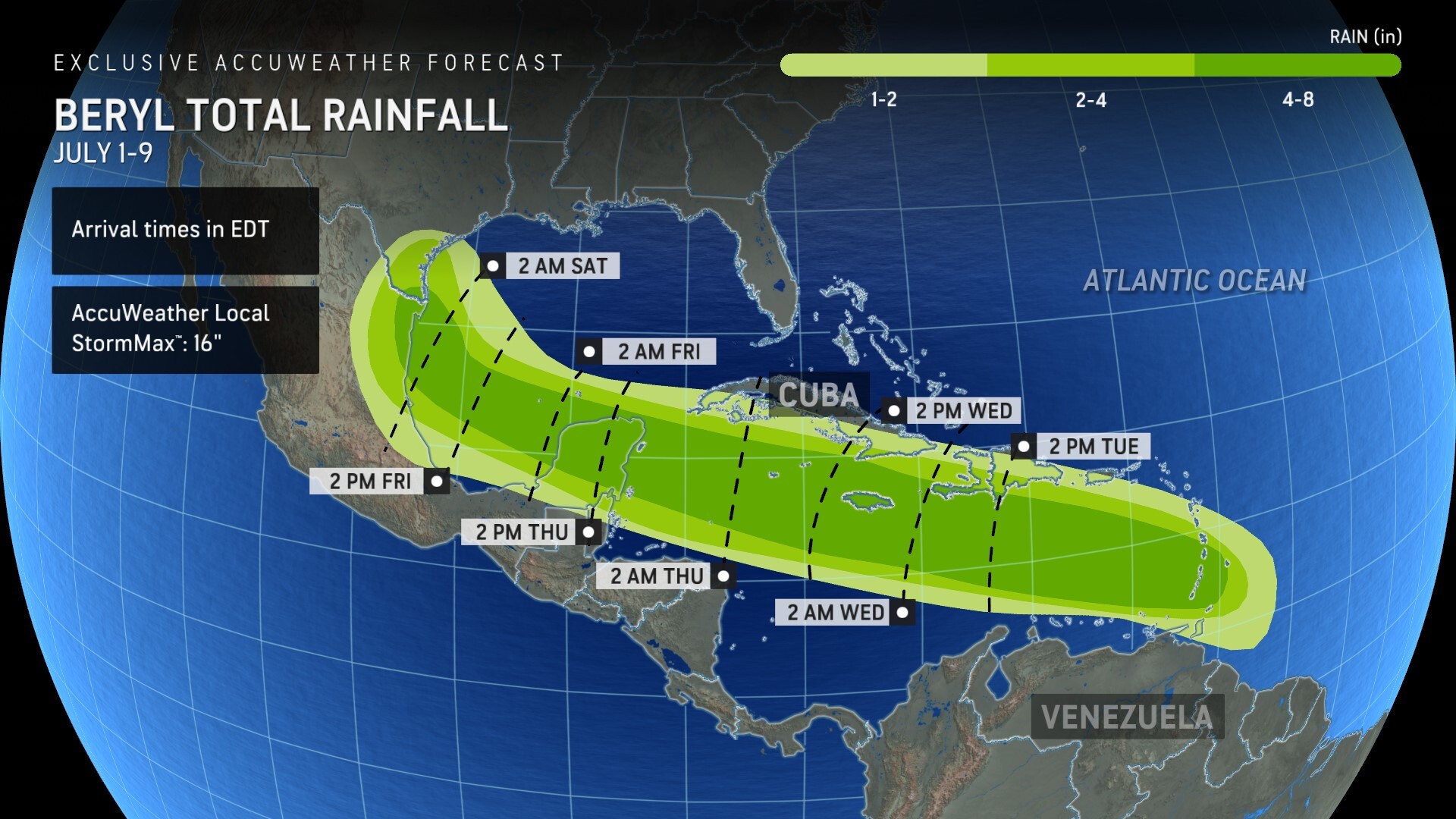
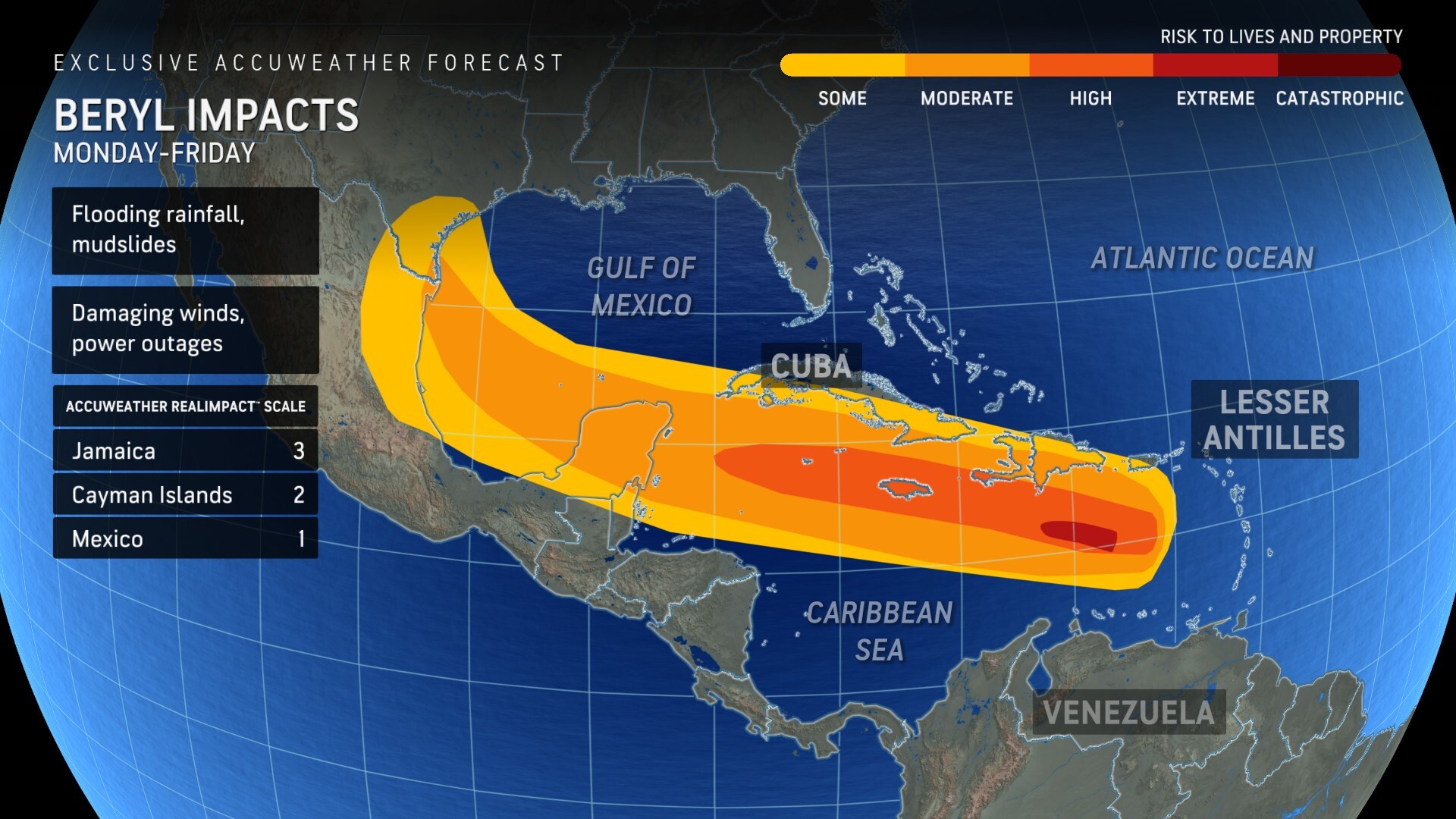
AccuWeather expert meteorologists are concerned about the growing threat of dangerous storm surge, destructive winds, and flooding rainfall in Jamaica from Hurricane Beryl.
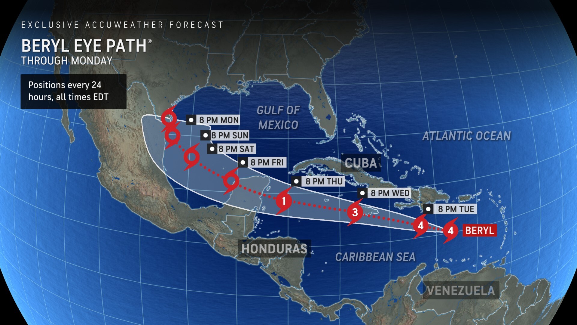
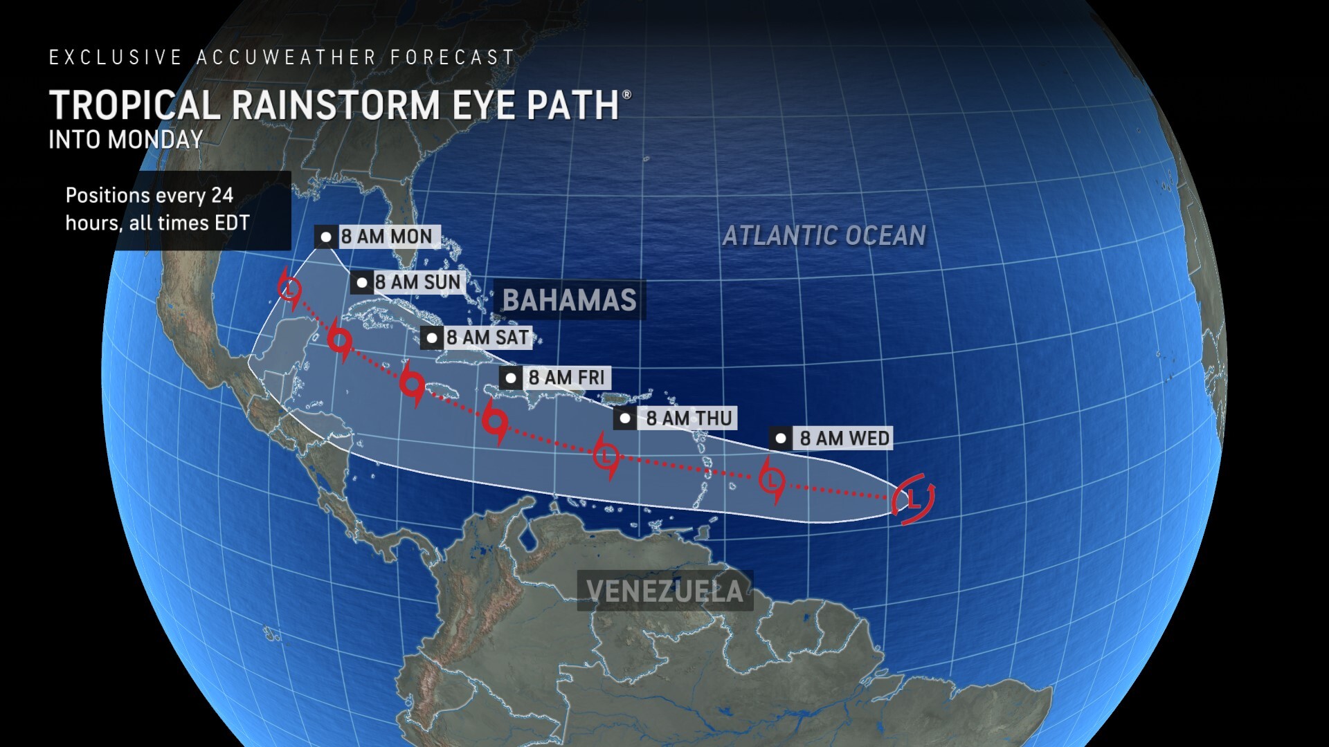
AccuWeather is now forecasting Beryl to be a Category 3 hurricane when it passes near or makes landfall in Jamacia Wednesday with maximum sustained winds of 111-129 mph.
There is a high risk to lives and property in Jamaica. The AccuWeather RealImpact™ Scale for Hurricanes for Jamaica is a 3. Preparations need to be completed by late Tuesday in Jamaica, as conditions will deteriorate rapidly Wednesday.
A 3 on the AccuWeather RealImpact™ Scale warns of widespread and substantial flooding, structural damage to buildings and trees, and major coastal inundation.
“We expect Beryl to maintain its intensity until it reaches 70 degrees west longitude, south of Santo Domingo. Once it reaches that point, we expect Beryl to encounter wind shear and begin the process of losing wind intensity,” said AccuWeather Chief On-Air Meteorologist Bernie Rayno. “Beryl is expected to track over or just south of Jamaica on Wednesday. Significant flooding, coastal inundation, and wind damage are all possible in Jamaica.”
Rayno said families and businesses in Jamaica need to be prepared for the threat of extended power and communication outages. Should the center pass directly over the island, the impacts can be devastating.
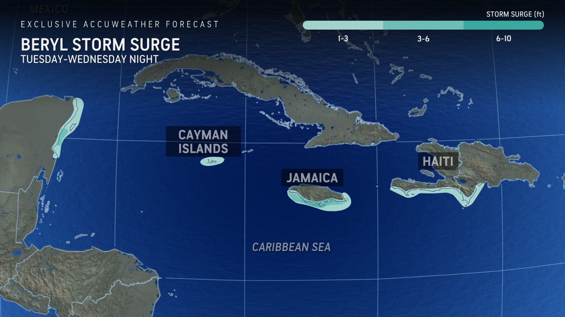
Several feet of storm surge could impact parts of Jamaica, Haiti and the Cayman Islands Tuesday through Wednesday night.
Beryl shatters records as “monster” Category 5 hurricane
Hurricane Beryl became the earliest Category 5 hurricane in the Atlantic basin on record late Monday night, when it intensified with 165-mph sustained winds.
“Beryl was in a perfect location for strengthening. There was very warm water, no dry air anywhere around the center of circulation, and there’s been no wind shear,” said Rayno. “On the islands hit hardest by Beryl, it’s going to take months or even years to recover.”
Homes, businesses, and communication infrastructure were damaged across parts of the Windward Islands Monday. The eye of Beryl passed directly over the island of Carriacou as a Category 4 hurricane with maximum sustained winds of at least 150 mph.
“Roughly 90 percent of the time, wind shear will destroy or weaken a hurricane. That 10 percent chance, when wind shear is in the right position, can help to ventilate a storm and allow more air to rise, therefore strengthening the storm. We saw that with Hurricane Lee last year, and we just saw that with Beryl,” explained AccuWeather Lead Hurricane Forecaster Alex DaSilva. “Beryl is going to maintain strong intensity as it moves through the Caribbean, but we’re not expecting a monster Category 5 hurricane later this week, like what we saw Tuesday morning."
Families & businesses along Texas coast need to prepare
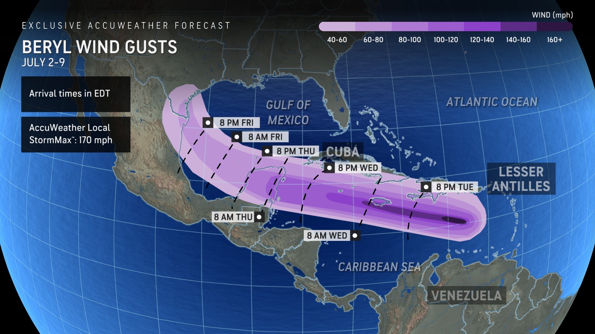
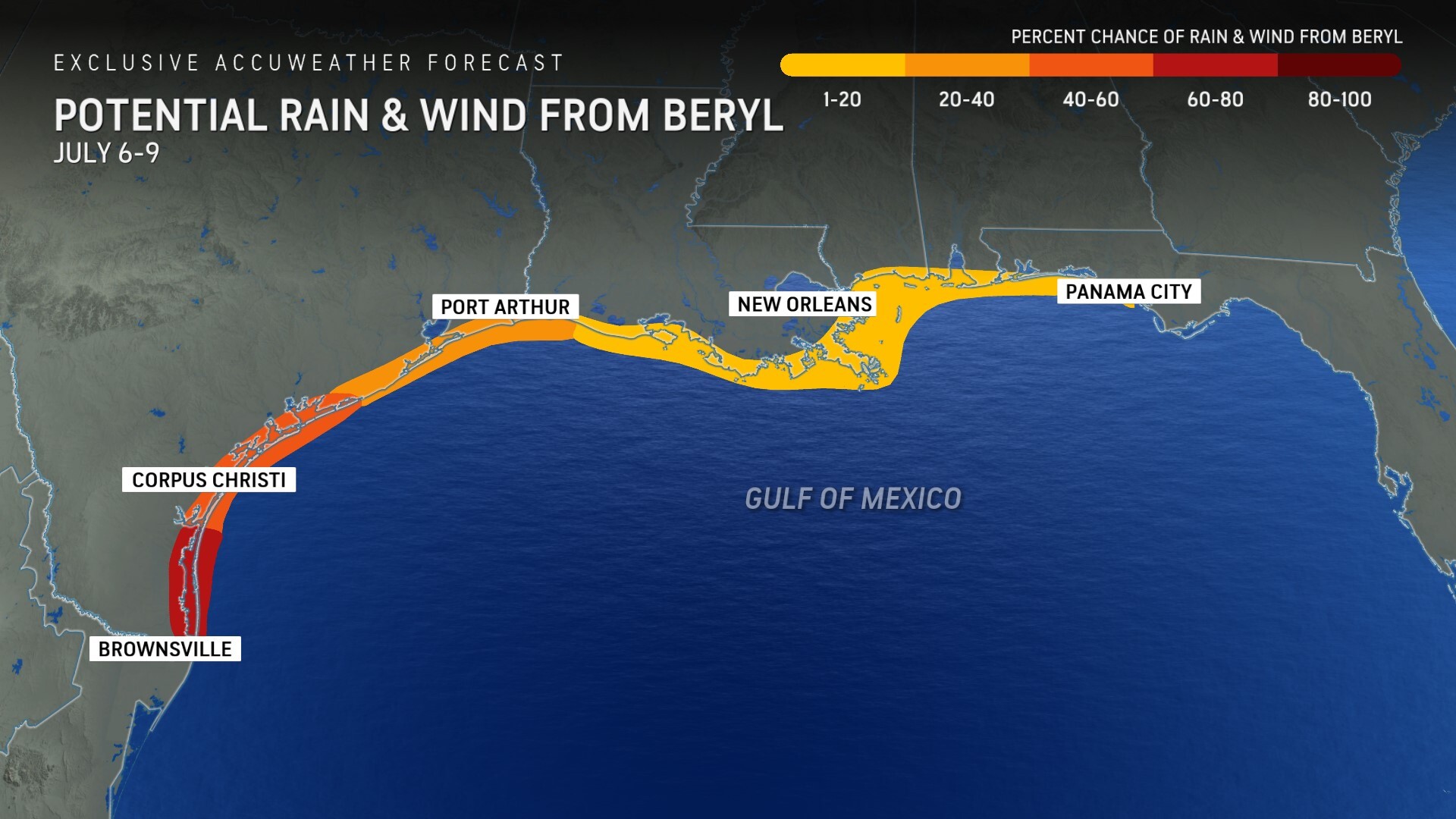
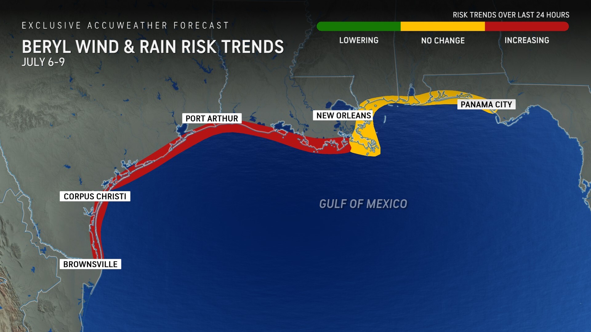
AccuWeather expert meteorologists are closely monitoring the potential of Hurricane Beryl tracking farther north throughout the week, which could bring impacts to the western Gulf Coast of the United States.
“We’re getting more concerned that the upper-level atmospheric winds that steer a hurricane like Beryl can support a turn to the north this weekend,” said DaSilva. “If Beryl is torn apart by wind shear over the next few days, it’s more likely to follow the trade winds and move west into Mexico. Unfortunately, we’re more concerned the storm will be a little stronger, which combined with the steering winds, may lead to Beryl moving toward the Texas Gulf Coast.”
AccuWeather expert meteorologists say there is an increasing risk of wind and rain impacts from Hurricane Beryl from the Louisiana coastline south of New Orleans and throughout the Texas coast. While AccuWeather is not, at this time, expecting Beryl to remain a major hurricane into the United States, it would still bring the threat for damaging wind gusts, flooding rain and some coastal inundation.
The highest risk of impacts in the U.S. are currently forecast to be south of Corpus Christi.
AccuWeather expert meteorologists are forecasting Beryl to approach the Yucatan Peninsula as a Category 1 hurricane on the Saffir-Simpson Hurricane Wind Scale Thursday night with maximum sustained winds of 74-95 mph.
Beryl is expected to lose wind intensity and cross the Yucatan Peninsula Friday as a tropical storm.
AccuWeather expert meteorologists expect Beryl to maintain tropical storm strength as it crosses the Bay of Campeche and enters the Gulf of Mexico, before it approaches the border of the U.S. and Mexico this weekend. It is possible that Beryl could regain hurricane strength during this time window as well.
How warmer oceans are fueling hurricanes
AccuWeather Climate Expert and Senior Meteorologist Brett Anderson says favorable weather patterns for tropical development, combined with warmer sea surface temperatures, are contributing to this explosive start to the hurricane season.
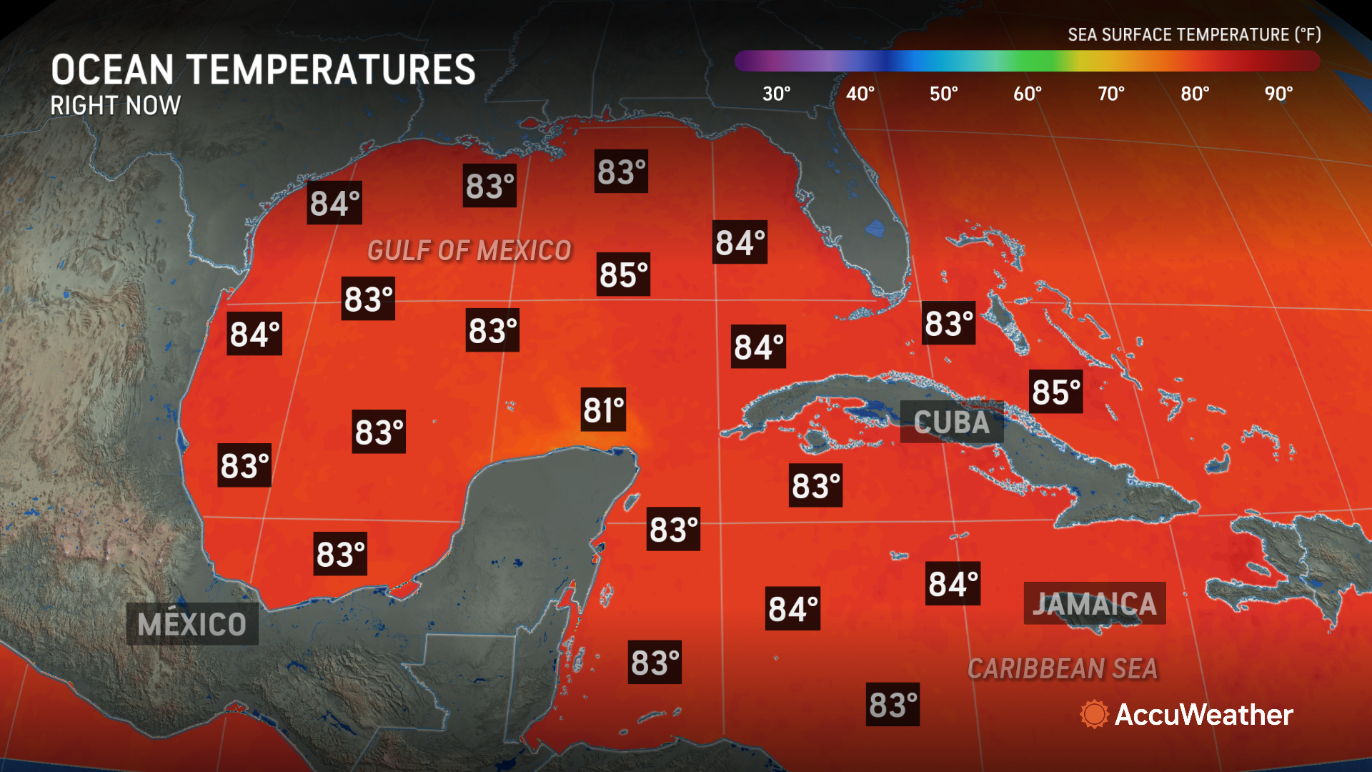
“The combination of human-induced climate change and some of the lingering impacts of what once was a moderate El Niño has caused sea surface temperatures in large portions of the Atlantic basin to continue to run at record high levels,” said Anderson. “In the Caribbean, sea surface temperatures are currently running above the 1991-2020 average for late September, which is normally the time of year when sea surface temperatures peak in that region of the world.”
Right now, the average sea surface temperature for the Caribbean is almost 85 degrees, compared to the historical average of 82 degrees in early July.
“That increase of 2.5 to 3 degrees in surface water temperature provides a tremendous boost of available energy for tropical storms or hurricanes as they pass through, which can lead to rapid strengthening,” said Anderson. “Having a Category 5 hurricane in this region of the world at the start of July is unprecedented in modern history. As the world's land and sea surface continues to warm due to climate change, hurricanes reaching major strength in the central Atlantic may, unfortunately, become more of the norm, even as early as the first weeks of June, over the coming decades.”
Anderson says the depth that warmer waters are reaching is also providing more fuel for tropical storms and hurricanes.
“It’s not just the surface waters that are running at record high levels. The ocean heat content, which measures the amount of heat in the ocean all the way down to 2000 meters (over 6,500 feet or 1.2 miles) is also running at record high levels in the Main Development Region of the central Atlantic and through the Caribbean Sea,” said Anderson.
AccuWeather first issued the U.S. 2024 Hurricane Forecast in March, warning of an “explosive” season. AccuWeather is forecasting 20-25 named storms and four to seven major hurricanes in the Atlantic basin this year.
DaSilva warned of the growing threat of rapid intensification this season in May. Tropical storms and hurricanes that rapidly intensify near coastal cities could leave families, businesses, and officials with less time to react, prepare and evacuate.
AccuWeather Forecast Graphics

Additional AccuWeather Resources:


