

AccuWeather meteorologists are available 24/7 to provide further insights and updates on evolving weather conditions. Please contact pr@accuweather.com during regular business hours, or support@accuweather.com or call AccuWeather’s Media Hotline at (814)-235-8710 at any time to arrange interviews with AccuWeather experts or to request the most updated graphics for print or broadcast.
Arctic blast with gusty winds and blowing snow could create hazardous travel conditions this week
Dec. 2, 2024
> Snow showers, snow squalls and a rapid temperature drop are expected in parts of the Northeast and Great Lakes region on Wednesday night
> A deep freeze and blustery winds are forecast across much of the Northeast, New England, Great Lakes and parts of the mid-Atlantic on Thursday
> Temperatures plunging 5-15 degrees below the historical average could lead to an increased risk of water pipes bursting in poorly insulated homes and businesses in parts of the Southeast on Thursday
AccuWeather Global Weather Center – Dec. 2, 2024
The coldest air of the season so far is expected to spread across the Northeast with gusty winds, rounds of snow and snow squalls that could create dangerous travel conditions by midweek.
“This is going to be a cold week for millions of people across the Northeast. There will even be a glancing blow of colder air across parts of the Southeast and the Carolinas,” AccuWeather Chief On-Air Meteorologist Bernie Rayno said. “This is a direct discharge of Arctic air. We’re concerned about the potential for travel problems Wednesday night and Thursday morning.”
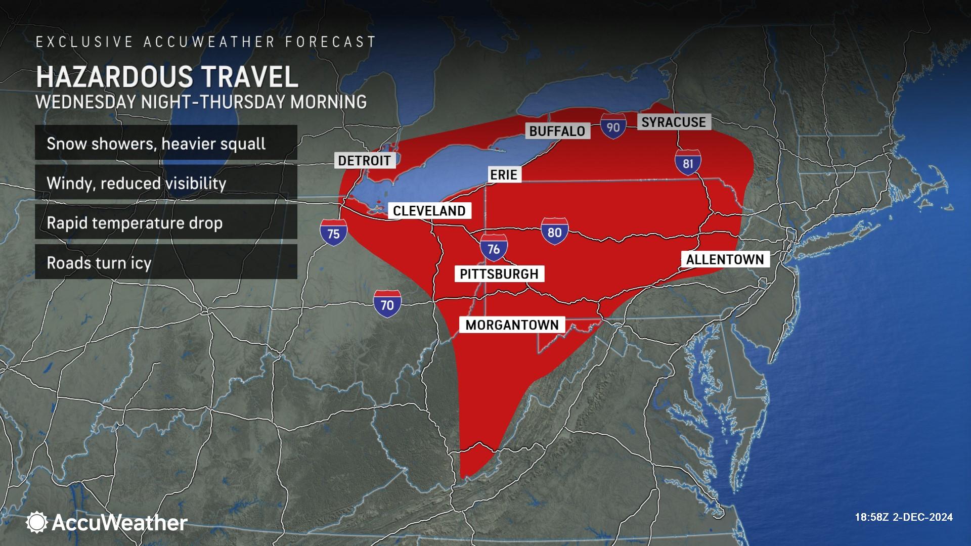
AccuWeather expert meteorologists are forecasting hazardous travel conditions Wednesday night with snow showers, snow squalls, gusty winds and the potential for slippery roads in parts of the interior Northeast, Great Lakes region and a portion of the Appalachians.
“The conditions expected Wednesday night could create chaos on the highways. Snow squalls can reduce visibility within a matter of seconds. A rapid temperature drop could lead to a layer of ice that is quickly coated by snow. People who on traveling through Syracuse, Buffalo, Erie, Cleveland, Detroit and Pittsburgh need to be prepared,” AccuWeather Chief Meteorologist Jon Porter warned. “We’re going to see a brief yet powerful blast of Arctic air moving through the northern Plains and surge across the Great Lakes into the Northeast.”
Some roads and highways near the Great Lakes may close due to the heavy rate of snow and near-zero visibility, similar to the travel issues during the Thanksgiving weekend, even though snow totals may not be measured in feet this week. Blowing and drifting snow may be significantly worse due to plunging temperatures and the snow becoming more dry and powdery in nature.
"A full-fledged blizzard could occur in areas downwind of the Great Lakes, including parts of the Buffalo and Cleveland metro areas, with snow falling at rates of 2 inches or more per hour,” Porter said. “Complete whiteouts are possible with winds gusting to 50 mph or even higher. Lake-effect snow bands can also be narrow, sometimes only 3 to 5 miles wide, where the intense snow is focused. Outside of the band, there can be little to even no snow falling with an unusually sharp variation between hardly any snow and the extreme blizzard. Within any of these heavy snow bands, should a traveler become stranded, the situation can quickly escalate to a life-threatening emergency."
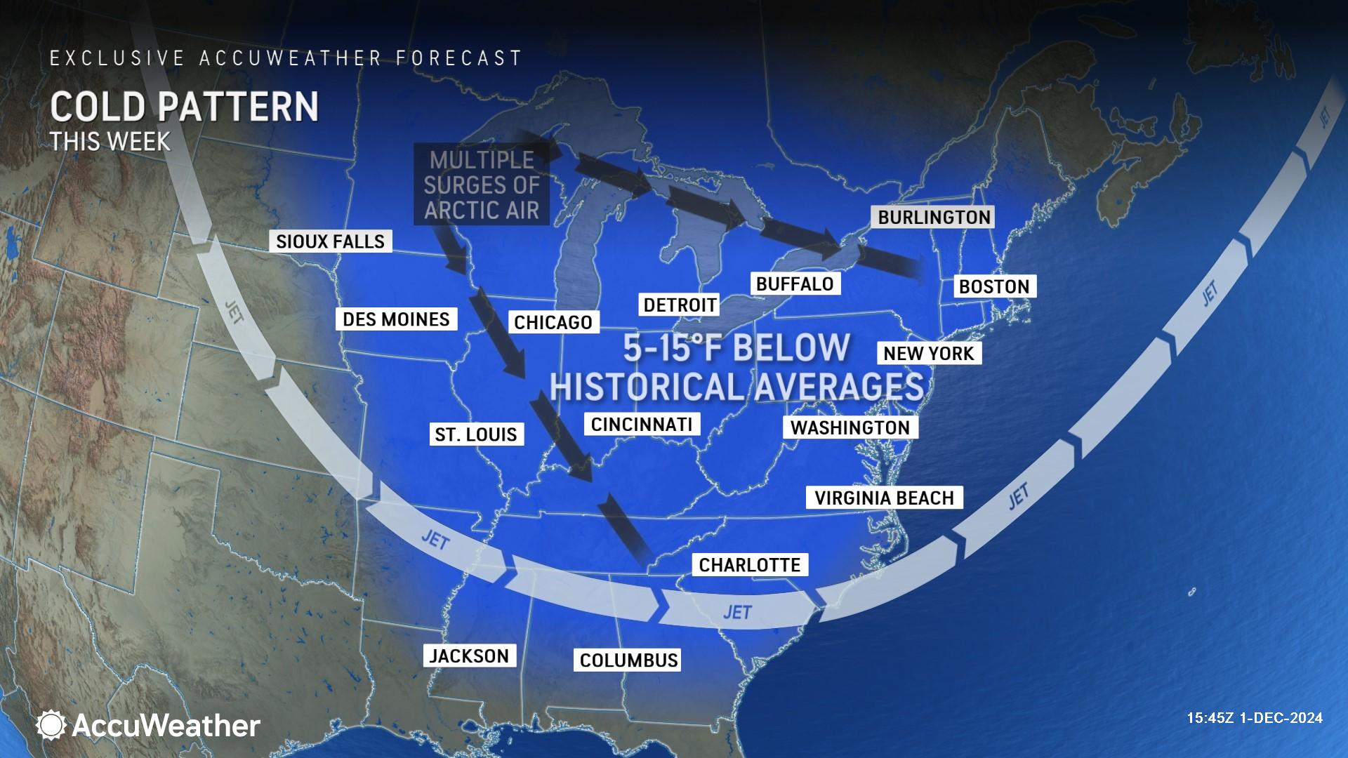
AccuWeather expert meteorologists say multiple surges of bitterly cold air will send temperatures plunging 5-15 degrees below the historical average at times this week across parts of the Midwest, Great Lakes, Northeast, New England, mid-Atlantic and areas of the Southeast.
For millions in the Northeast, it could end up being the coldest start to December in over a decade, driving an increased demand for electricity and home heating oil. The colder air will also allow additional opportunities for ski mountains to create artificial snow and build the snowpack on the slopes.
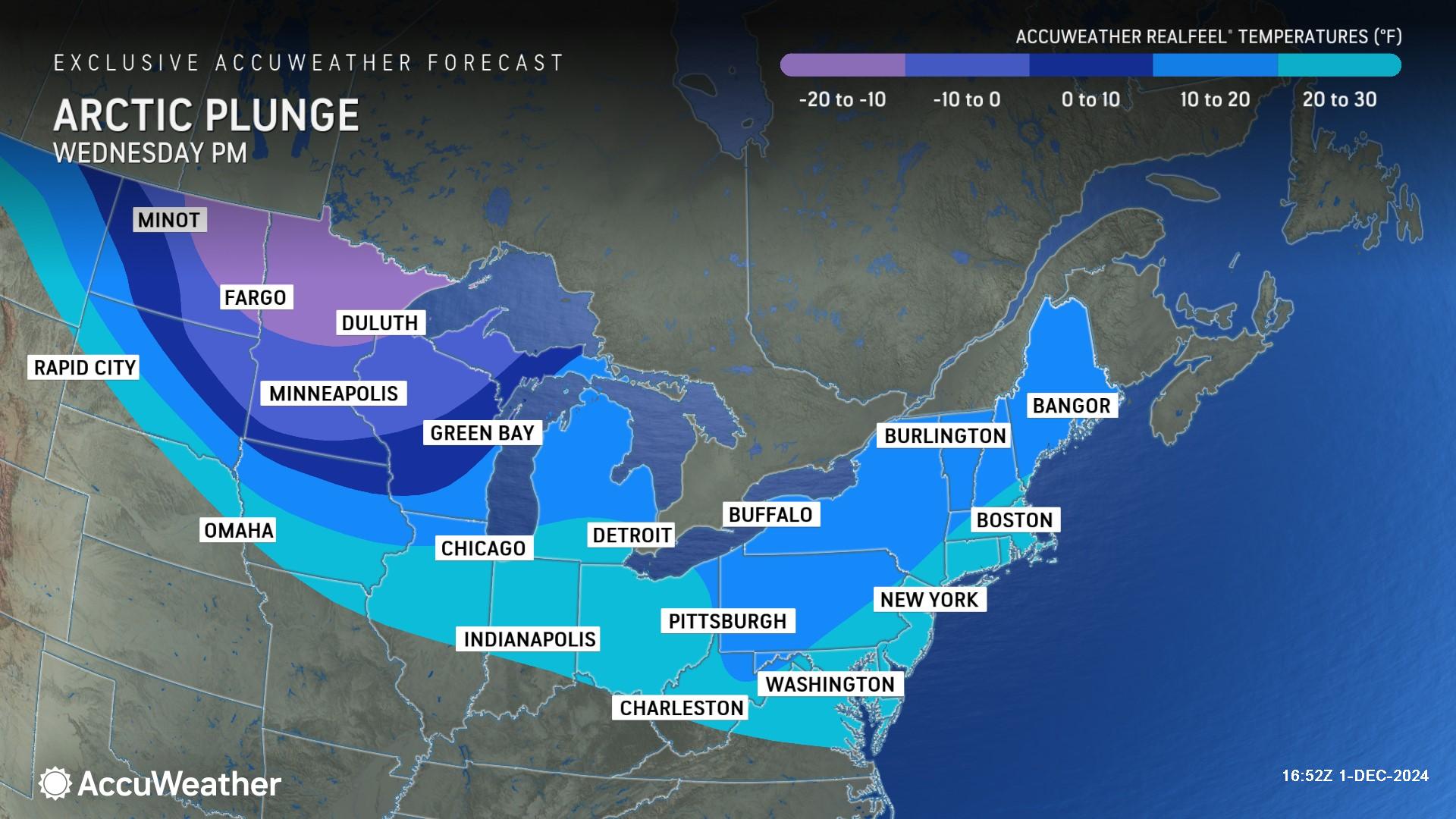
AccuWeather is forecasting temperatures to plunge across the region on Wednesday, with AccuWeather RealFeel® Temperatures dipping to 10-20 degrees in parts of the Northeast.
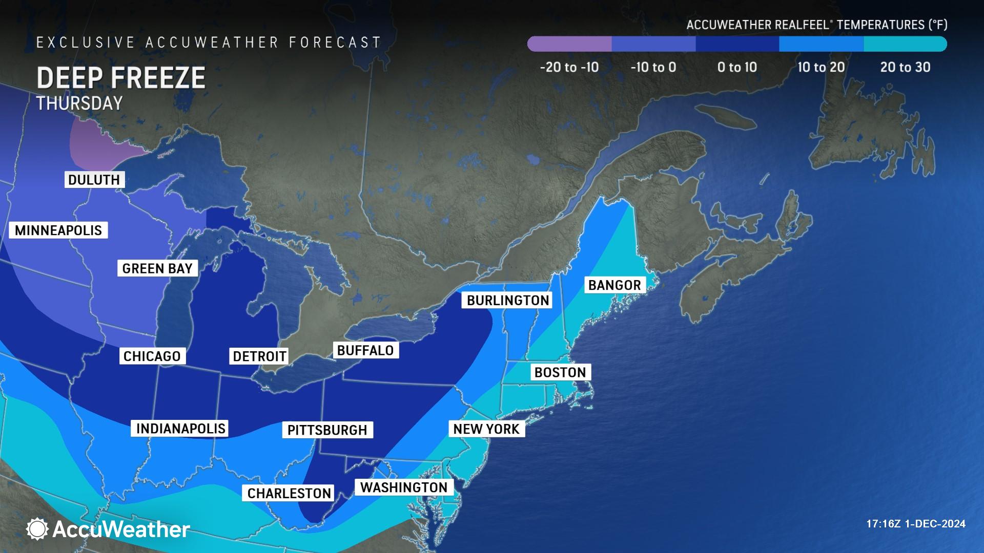
A deep freeze will expand on Thursday, with AccuWeather RealFeel® Temperatures reaching 0-10 degrees in parts of the Northeast and Midwest. AccuWeather RealFeel® Temperatures could drop to -20 degrees in parts of the northern Plains.
AccuWeather expert meteorologists warn that it will get cold enough in parts of the Southeast with a penetrating breeze to be a concern for water pipes bursting in poorly insulated areas of homes and businesses. The freezing temperatures are also a concern for families living in tents, campers and other temporary housing in communities hit hard by catastrophic flooding from Helene. The wintry blast could cause issues with temporary water distribution sites, as well as slow ongoing recovery and construction efforts in the region.
Temperatures are forecast to dip into the 20s in Atlanta, Charlotte, Birmingham, Alabama, and Columbia, South Carolina, on Thursday night. People who have not yet made winter preparations for insulating and vulnerable outdoor garden operations in the interior Southeast and along the mid-Atlantic coast should do so as soon as possible to avoid damage from the upcoming cold blast.
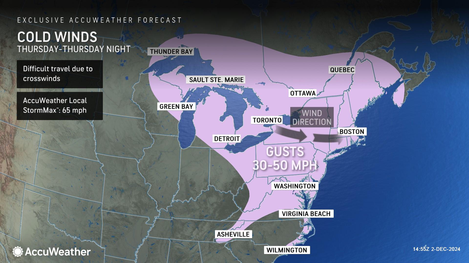
Blustery winds gusty 30-50 mph could lead to dangerous travel across the Great Lakes and Northeast on Thursday, with an AccuWeather Local StormMax™ of 65 mph.
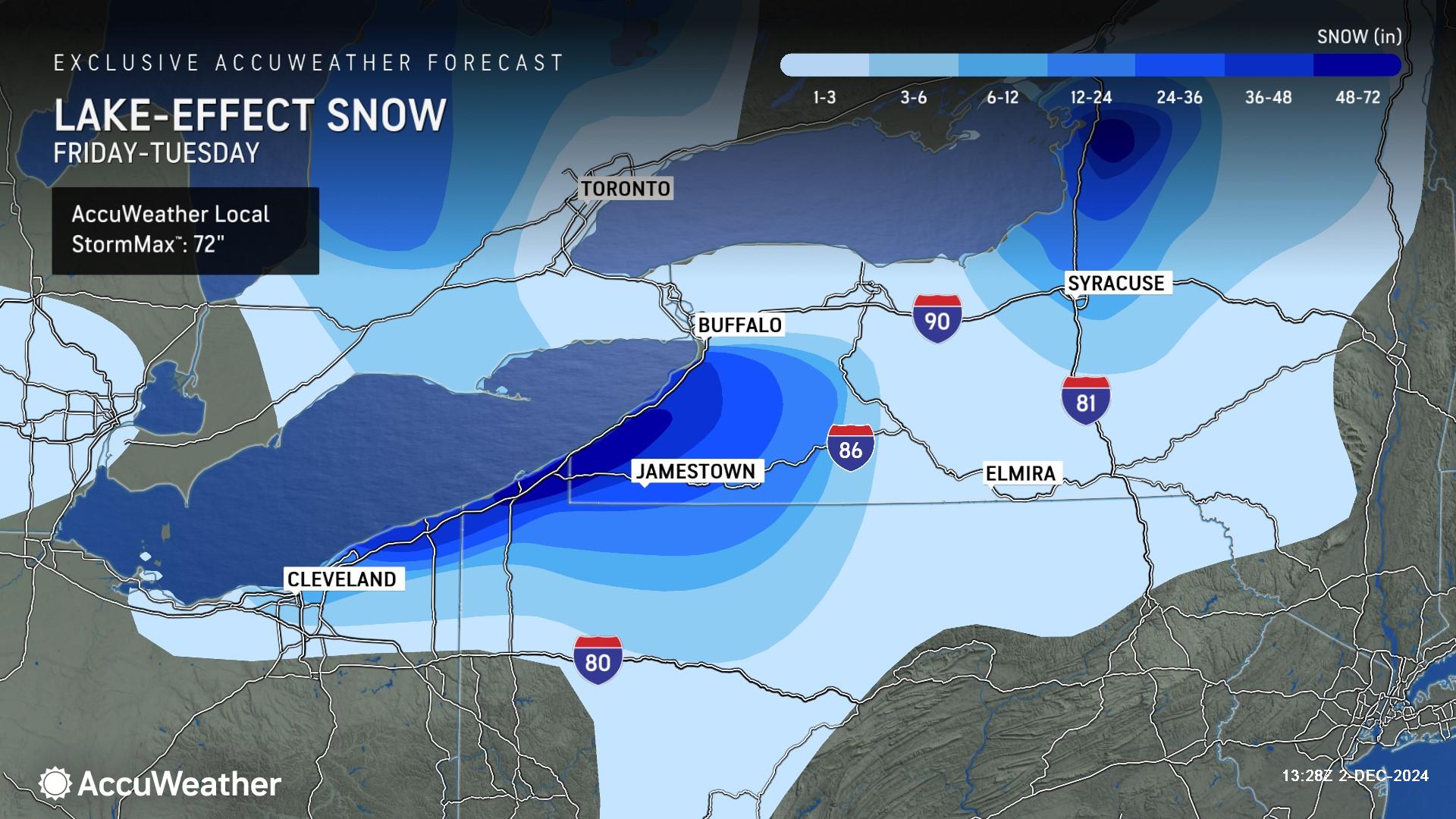
Areas near the Great Lakes have been left buried in feet of lake-effect snow that has been accumulating since Friday. The AccuWeather Local StormMax™ has been increased to 72 inches of snowfall through Tuesday.
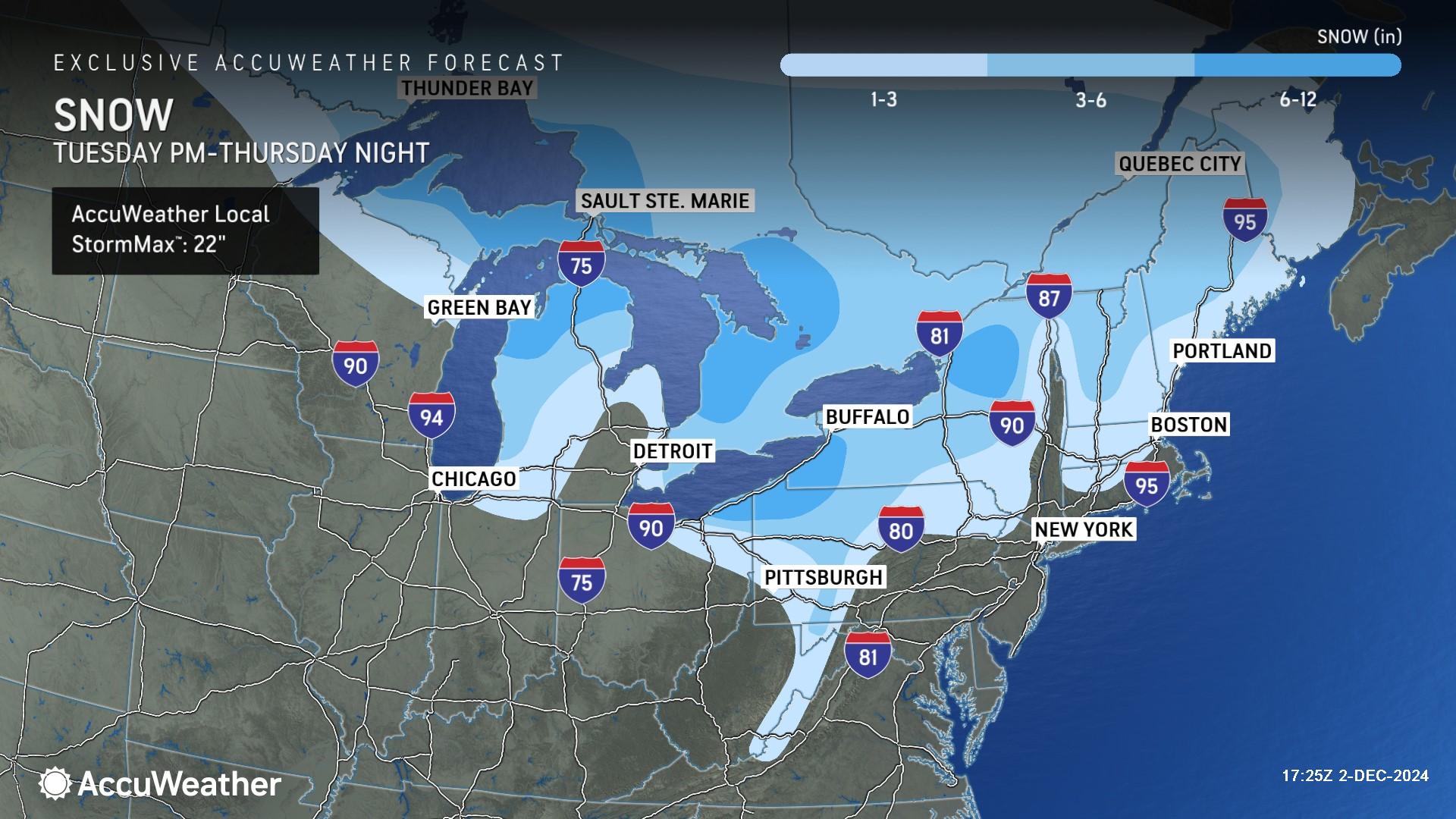
AccuWeather expert meteorologists are forecasting an additional 6-12 inches of snow near the Great Lakes from Tuesday through Thursday night, with an AccuWeather Local StormMax™ of 22 inches.
Additional AccuWeather Resources:
Canada storm with snow, Arctic blast to sweep across Midwest and Northeast
5 feet of lake-effect snow buries New York, shuts down highways
Lake-effect snow stalls travel for millions
What is lake-effect snow?
Meteorological winter versus astronomical winter


