AccuWeather meteorologists are available 24/7 to provide further insights and updates on evolving weather conditions. Please contact pr@accuweather.com during regular business hours, or support@accuweather.com or call AccuWeather’s Media Hotline at (814)-235-8710 at any time to arrange interviews with AccuWeather experts or to request the most updated graphics for print or broadcast.
Tropical Rainstorm to soak the Gulf coast as surge of tropical activity intensifies in the Atlantic basin
August 30, 2024
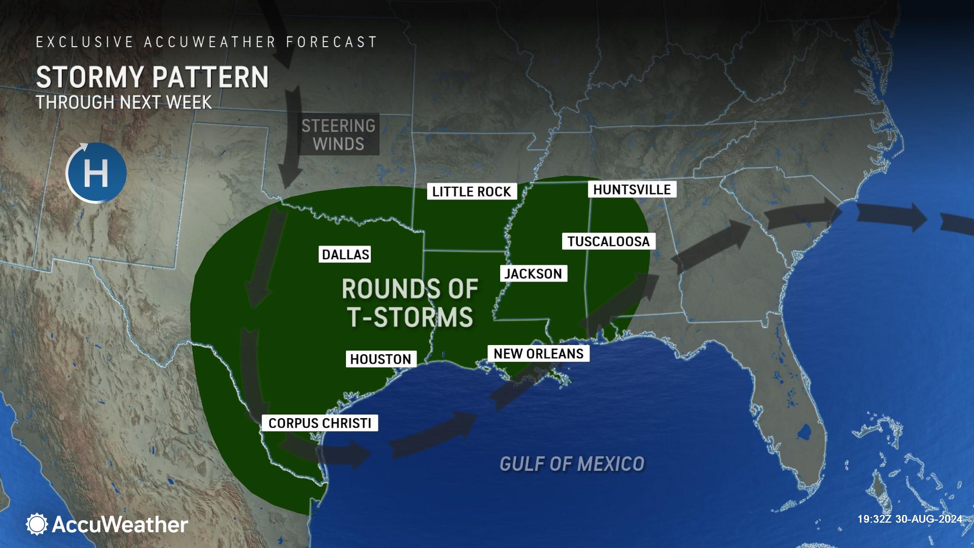
> Drenching rainfall could cause flooding problems in parts of Texas and Louisiana
this weekend

> Potential for multiple named storms in the Atlantic basin within the next two
weeks

> Extremely warm water temperatures could support rapid intensification
AccuWeather Global Weather Center – August 30, 2024
AccuWeather expert meteorologists are closely monitoring multiple potential tropical threats in the Atlantic basin over the holiday weekend.
Experts at the AccuWeather Global Weather Center dubbed one of the potential threats in the northwestern Gulf of Mexico a tropical rainstorm on Friday afternoon. The tropical rainstorm could bring heavy rainfall, possible flash flooding and gusty winds to parts of Texas and Louisiana over the holiday weekend.
AccuWeather expert meteorologists refer to certain developing tropical threats as tropical rainstorms to raise awareness about the disruptions, damage and dangers that a system could pose before it becomes a named storm.
“It is very important for people along the Gulf Coast, and the Eastern Seaboard, to frequently check AccuWeather forecast updates over the holiday weekend and through next week,” said AccuWeather Chief Meteorologist Jon Porter. “Just as we warned last week, tropical activity is ramping up quickly as we head into the month of September.”
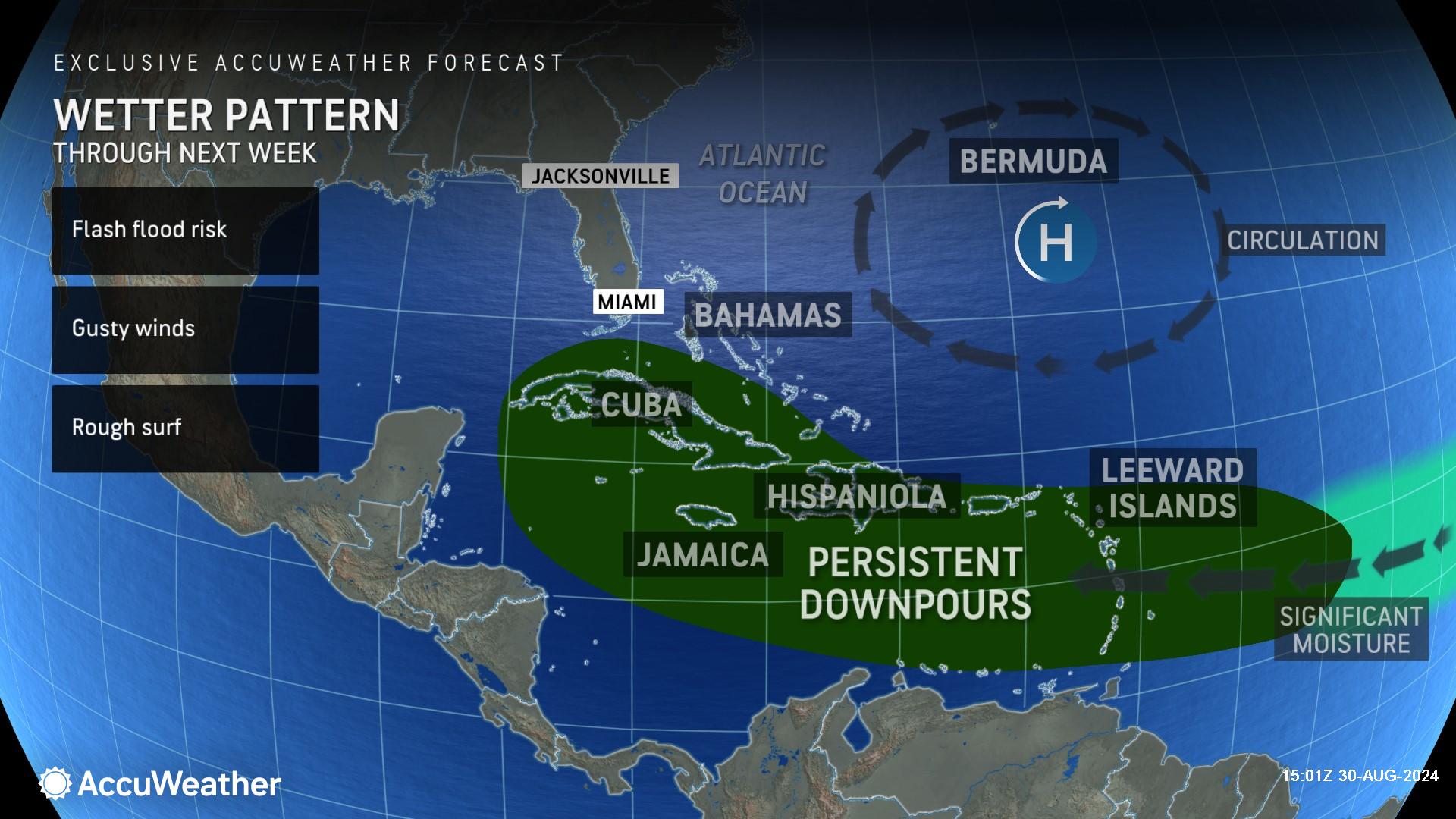
Tropical development is most likely in the Caribbean during the first week of September, where there is a broad zone of showers and thunderstorms.
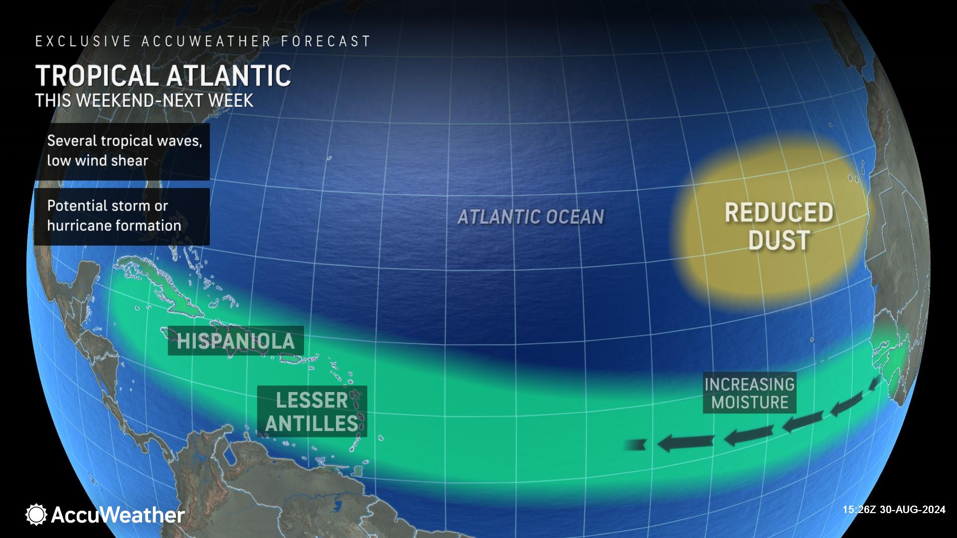
There are other zones that AccuWeather expert meteorologists are monitoring as well, including the waters just of the Atlantic coast of the United States and a feature pushing off the coast of Africa. The area in the central t Atlantic contains multiple batches of showers and thunderstorms that extend for close to 1,000 miles.
"We expect that at least one feature will take hold within the zone of moisture in the coming days," said AccuWeather Chief On-Air Meteorologist Bernie Rayno.
Rayno says wind shear is low and the water temperatures are sufficiently warm to foster tropical development in the area ahead of the zone of showers and thunderstorms.
In order for a tropical depression to be declared by the National Hurricane Center, there must be complete circulation with maximum sustained winds of 38 mph or less. Usually, showers and thunderstorms cluster near a center of circulation on satellite images and radar when a tropical depression is about to form.
Rounds of drenching showers and gusty thunderstorms will move slowly westward across portions of the Leeward and Windward islands that make up the Lesser Antilles on the eastern edge of the Caribbean Sea. The greatest concentration of the downpours will be over the Windwards.
The downpours will bring needed rainfall to some areas but may also trigger flash flooding in extreme cases. Several inches of rain may pour down in some locations from this weekend into early next week. Parts of the Windwards were still recovering from extensive damage from Hurricane Beryl earlier this summer and may still be experiencing damaged infrastructure.
"Next week, the chances of development will likely increase substantially," said Rayno. "We will likely have a named system, a tropical storm in there.”
The next name on the list of tropical storms for the 2024 Atlantic hurricane season is Francine.
If this potential tropical threat develops, there is a wide-ranging area where a tropical storm or hurricane might track after departing the Caribbean during the weekend after Labor Day. Steering breezes might continue to guide the system westward into Central America and southeastern Mexico during the second week of September. In another scenario, which poses a potential direct threat to the U.S., steering breezes and interactions with the jet stream could pull a tropical storm or hurricane into the Gulf of Mexico.
AccuWeather meteorologists are also monitoring a separate area in the Atlantic for tropical development. As a batch of thunderstorms moves well off the coast of Africa later next week, a tropical storm may form over the middle of the ocean. Anticipated steering winds would likely keep this feature away from land.
Another area that will be watched closely for development later next week is just off the Atlantic coast of the U.S.
Porter says there are other factors that could contribute to very impactful weather in parts of the U.S. next week.
“A potent jet stream disturbance intensifying over the eastern United States could produce the risk for heavy rainfall and flooding concerns in parts of the East. The ground is saturated from recent heavy rains, further amplifying the risk for flooding from persistent downpours,” Porter explained. “At the same time, this potent jet stream disturbance can also guide a tropical storm or hurricane, if one develops in the Caribbean next week, into the Gulf of Mexico, which is a precarious place relative to potential United States impacts."
After Francine, the following three storm names for 2024 in the Atlantic basin are Gordon, Helene and Isaac.
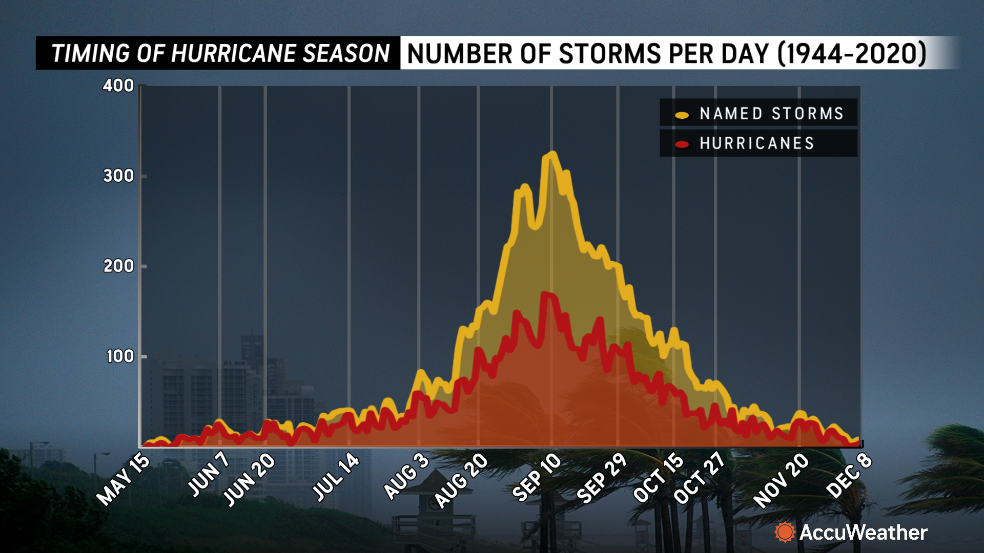
AccuWeather expert meteorologists say there will likely be a surge of tropical activity in September, following an unusually quiet lull during much of August, in the wake of Hurricanes Debby and Ernesto.
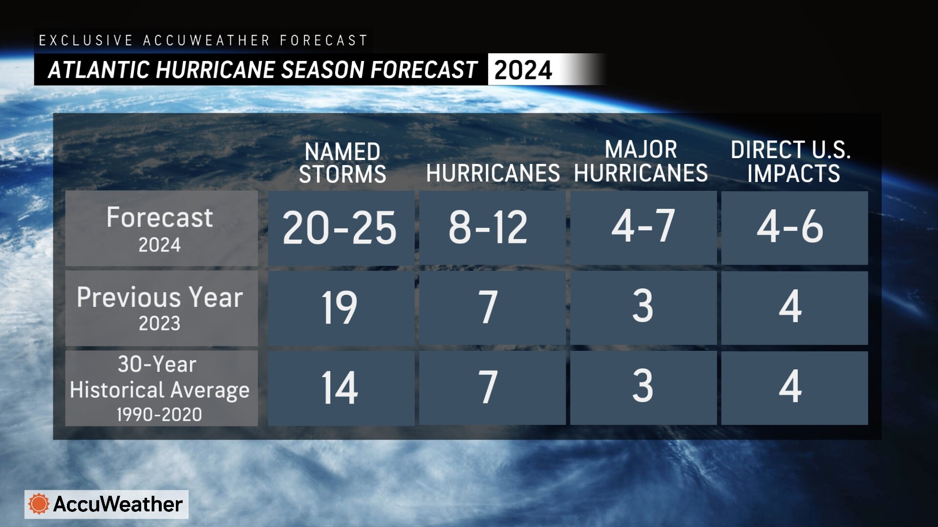
AccuWeather was the first source to issue an Atlantic hurricane season forecast in March, predicting 20-25 named storms and 4-6 direct impacts to the United States. Porter says due to the unusual lull in activity in August due to dry air, Saharan dust, and persistent wind shear, it is more likely that 20-23 named storms will develop this year. Since water temperatures are exceptionally warm and more conducive conditions are expected in September and October, Porter says 24 or 25 named storms can not be ruled out.
AccuWeather expert meteorologists say it is rare for an active named system not to be present during the Labor Day weekend, but warn that conditions in the Atlantic can change quickly. Porter says people need to be prepared for the potential of multiple named storms in the basin within the next two weeks.
AccuWeather Forecast Graphics
Additional AccuWeather Resources:
September surge: Tropical activity increasing in Caribbean, Atlantic and Gulf
Hurricane Tracking & Storm Radar
AccuWeather Forecasts Explosive 2024 Hurricane Season
Rapidly Intensifying Hurricanes Near Coastline Pose Major Threat To U.S. This Season
AccuWeather Forecasting 6 to 10 named storms during Supercharged September


