AccuWeather meteorologists are available 24/7 to provide further insights and updates on evolving weather conditions. Please contact pr@accuweather.com during regular business hours, or support@accuweather.com or call AccuWeather’s Media Hotline at (814)-235-8710 at any time to arrange interviews with AccuWeather experts or to request the most updated graphics for print or broadcast.
Summer heat intensifies across much of the country ahead of soggy Labor Day holiday weekend for millions of Americans
August 26, 2024
Drenching showers and severe thunderstorms could affect many areas in the
central and eastern United States for at least part of the last unofficial weekend
of summer as heat and the risk of wildfires slowly build in the West.
AccuWeather Global Weather Center – August 26, 2024
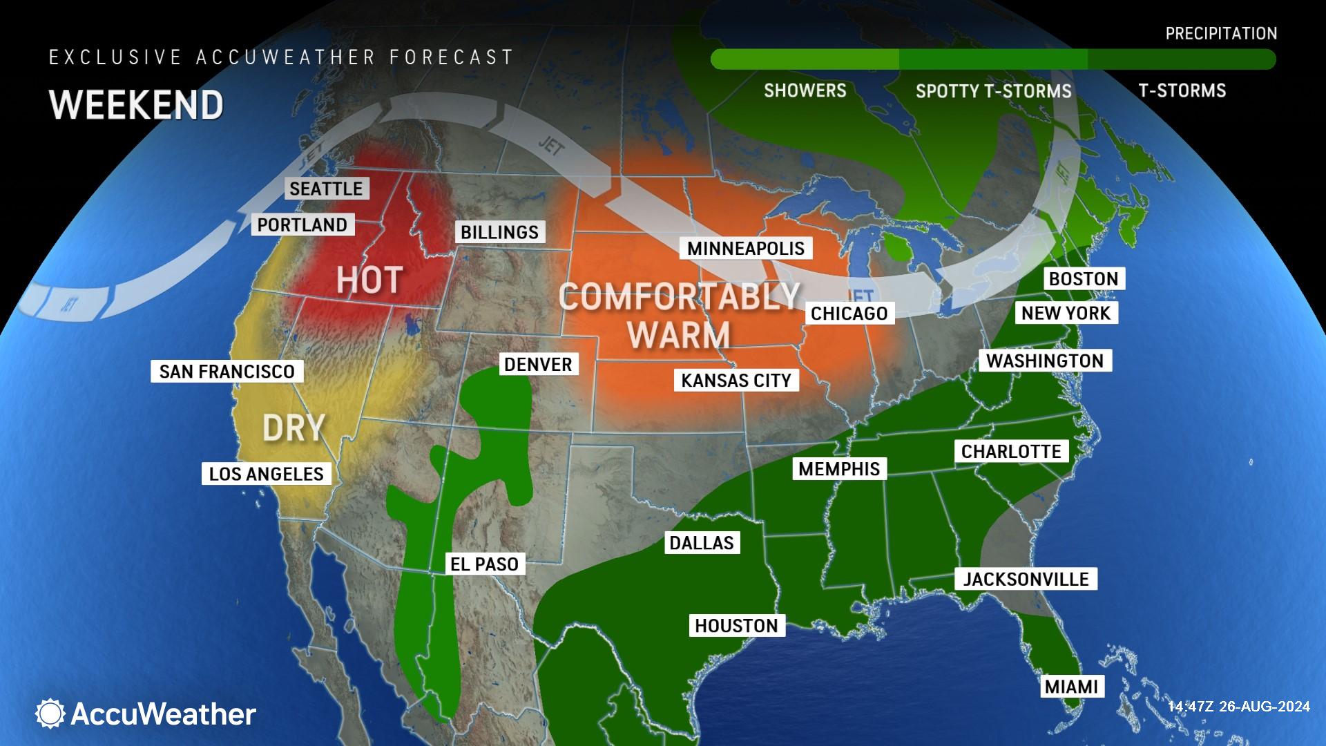
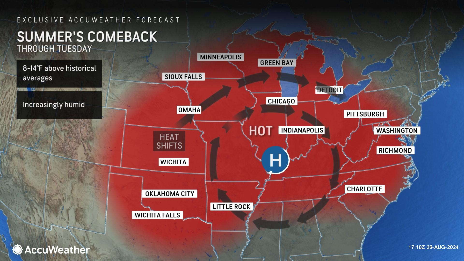
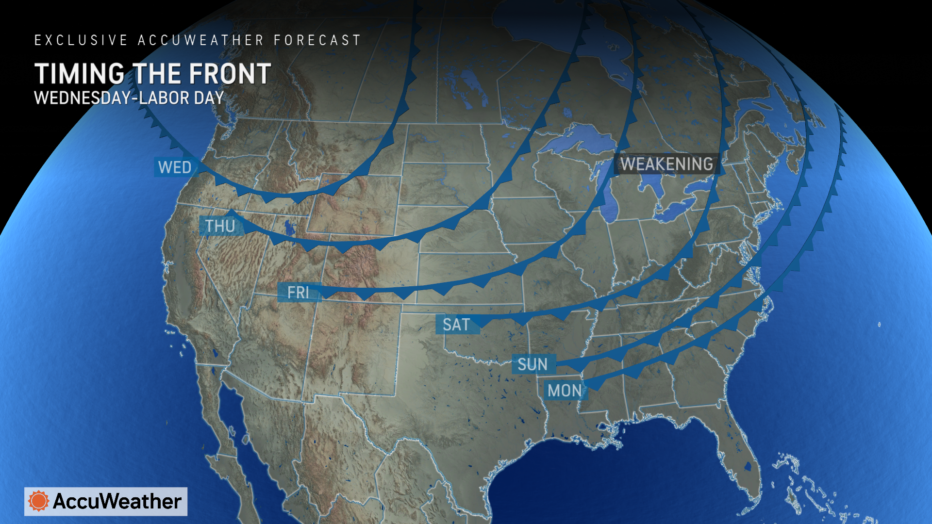
AccuWeather Lead Long-Range Expert Paul Pastelok says the large heat dome of high pressure that is building from the Midwest to parts of the East will break down late this week and over the weekend as a strong cold front slices southeastward.
“A strong cold front will move through the eastern third of the nation over the holiday weekend. Showers and a few strong, gusty thunderstorms are likely,” said Pastelok. "The big travel day on Friday will feature heavy showers and gusty thunderstorms from the Midwest to the south-central Plains along the front, which can lead to delays at airports and roadways from Oklahoma City and Dallas to Detroit and Chicago.”
Tropical trouble brewing in the Atlantic?
AccuWeather expert meteorologists say there is a low risk of potential tropical development east of the Lesser Antilles between Saturday and Labor Day.
Impacts are not expected in the United States over the holiday weekend.
The team of hurricane experts at the AccuWeather Global Weather Center issued a forecast update last week warning of six to 10 named storms during a “Supercharged September.”
AccuWeather Lead Hurricane Expert Alex DaSilva says conditions are expected to become more conducive for tropical development in the very warm waters of the Atlantic basin starting next week.
Heat wave bakes the Midwest ahead of holiday weekend
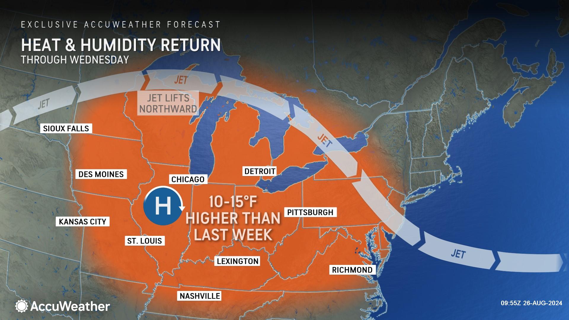
Temperatures are climbing 8-14 degrees above the historical average in parts of the Midwest this week as a heat wave grips the region with higher humidity levels.
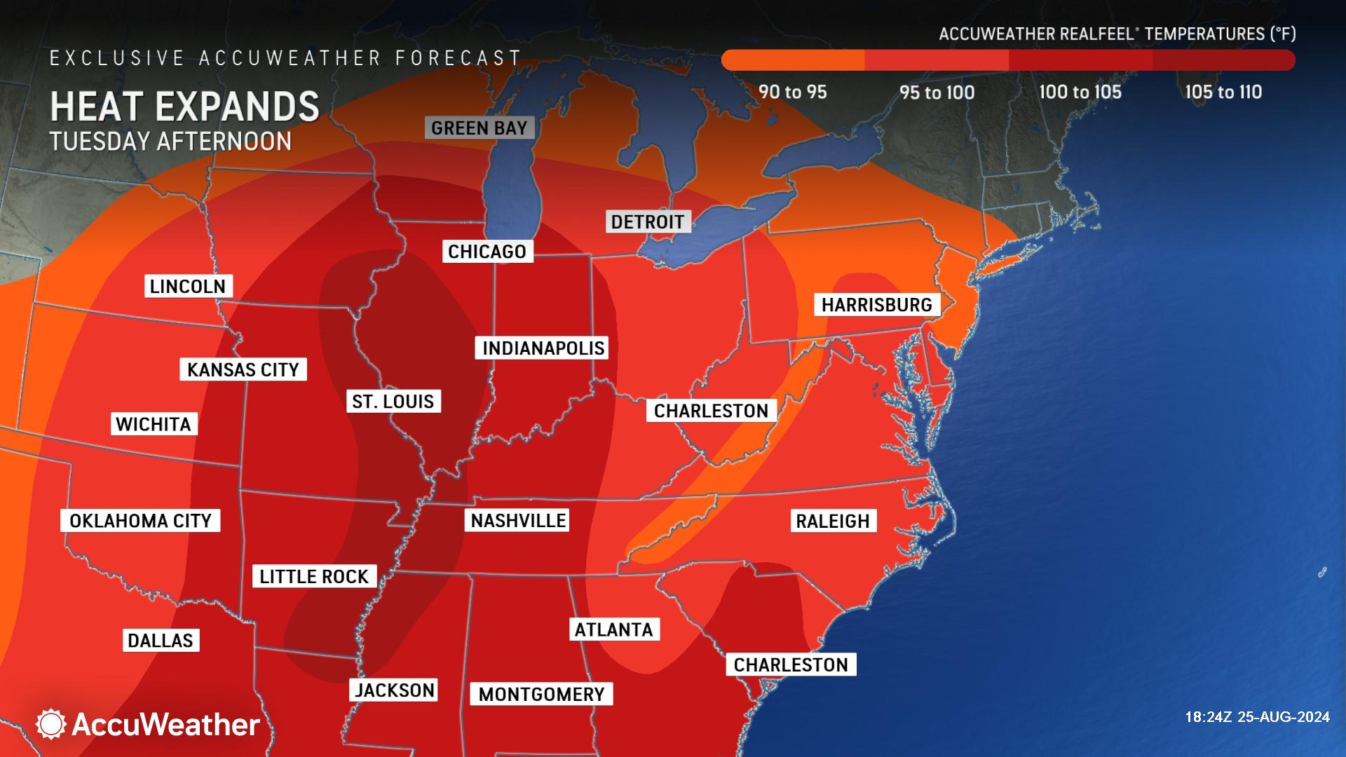
AccuWeather expert meteorologists say daily high temperatures in the 70s last week will be replaced by sweltering temperatures in the 90s and 100s on Tuesday.
“The heat wave is shifting and expanding from the mid-South into the Midwest,” said AccuWeather Long-Range Expert Joe Lundberg. “Chicago, St. Louis, Indianapolis and Cincinnati are all going to feel the heat this week.”
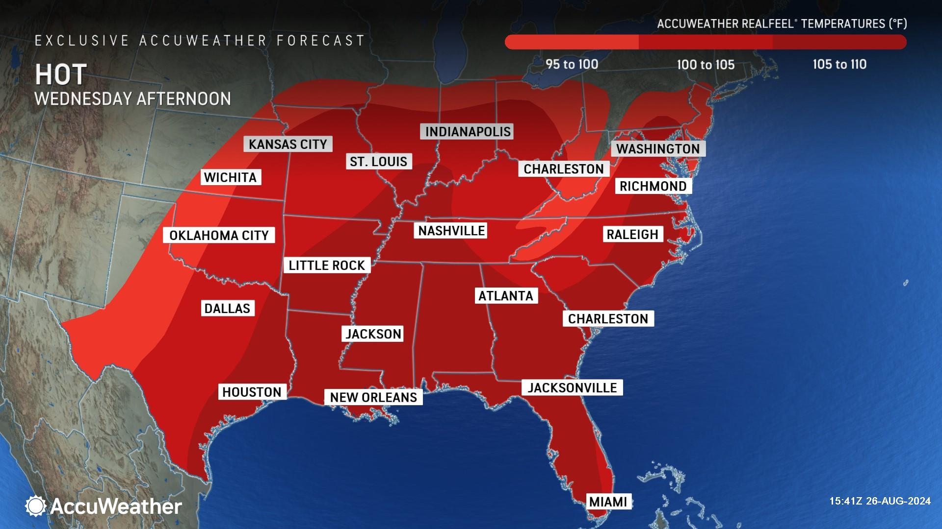
High humidity levels will make the heat feel up to 15 degrees warmer than the actual thermometer reading.
Some areas in the Midwest will feel the localized influence of evapotranspiration this week, from the massive corn crop producing moisture which is then transferred into the atmosphere.
AccuWeather expert meteorologists say one cold front will knock down temperatures on Tuesday into Wednesday, followed by a second cold front moving through later in the week, into the holiday weekend.
Summer heat rebounds in the Northeast before weekend cooldown
AccuWeather expert meteorologists say summer heat and humidity are returning to parts of the Northeast this week following a recent stretch of mild temperatures.
“It should feel like summertime for much of the mid-Atlantic region this week, especially after the recent early taste of autumn,” said AccuWeather Chief On-Air Meteorologist Bernie Rayno.
A southward dip in the jet stream will prevent heat from reaching parts of New England and areas just off the mid-Atlantic coast.
AccuWeather expert meteorologists say a cold front will knock back temperatures heading into Labor Day weekend.
Spotty thunderstorms in the central Appalachians and mid-Atlantic will become more numerous and widespread in the Northeast by Saturday.
Pastelok said there will be dry periods over the weekend, but a number of storms that erupt could be severe with gusty winds and flooding downpours.
Drier air is forecast to push across the central Appalachians to the upper mid-Atlantic on Sunday, with drenching showers and strong thunderstorms to extend from the lower Mississippi Valley to the southern Appalachians and the lower part of the mid-Atlantic, including the beaches from southern New Jersey to the Carolinas.
"It is possible there is another big flash flood event somewhere in the East as the front slows its forward speed from Saturday to Sunday," Pastelok warned.
Stormy and hot weekend for the Gulf Coast states
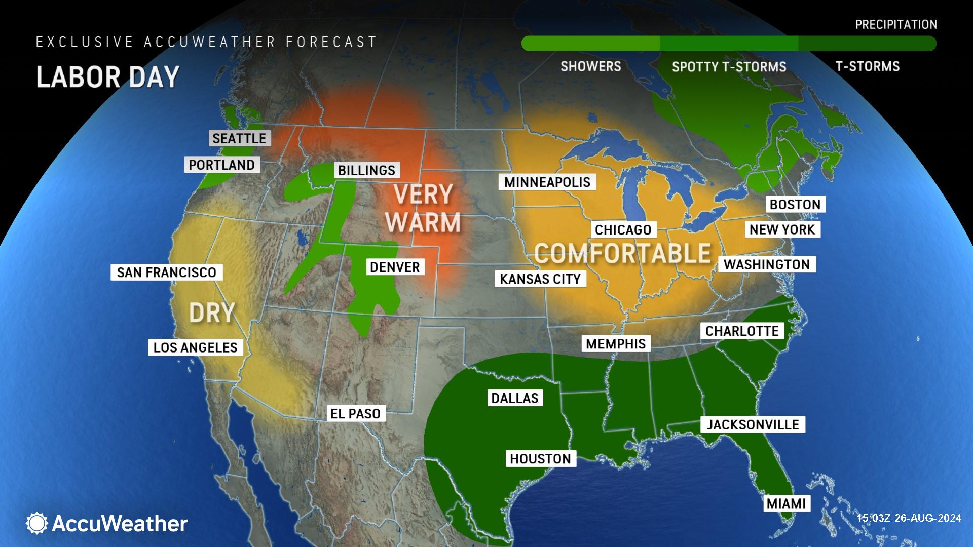
Summer heat will stick around much of the Gulf Coast region this week, but rain and storms could dampen beach plans over the holiday weekend.
AccuWeather RealFeel® Temperatures are forecast to hit 105-110 degrees by midweek in parts of Texas, Louisiana, Alabama, Mississippi and Florida.
Pastelok says much of the zone from the Gulf coast to the southern Atlantic coast, north of the Florida Peninsula, could be quite wet due to showers and locally severe thunderstorms on Monday.
"Labor Day may not be a good beach day for these areas in the South," said Pastelok.
Heat and wildfires in the West
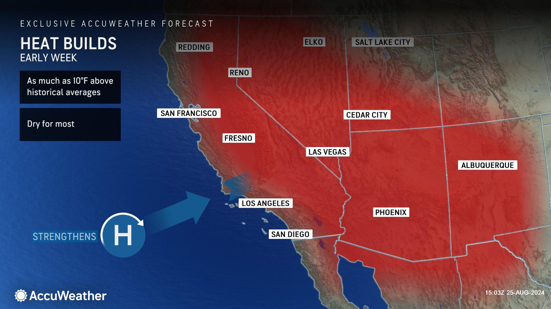
AccuWeather expert meteorologists say typical late-summer heat will have the biggest impact on tens of millions over the interior West, with temperatures that run up to 10 degrees above the historical average.
AccuWeather Meteorologist Grady Gilman says some areas are experiencing a 35-degree temperature swing in the span of one week. The warm pattern follows cool conditions that affected much of the region this past weekend, which included some snow for the high country of the Sierra Nevada and Cascades.
“An unusually strong storm brought unseasonably cool weather to much of the West coast late last week,” explained Gilman. “Temperatures were 20-25 degrees below historical averages and even set daily record low maximums.”
The high temperature in Sacramento, California, failed to reach 80 degrees last Friday, marking one of the coolest August days on record. A 64-day stretch of triple-digit heat in Las Vegas, Nevada, ended last Friday when the mercury topped out at 96 degrees.
Gilman says temperatures across much of the West and Southwest will climb 10 degrees above the historical average by Wednesday.
“A noticeable warmup will begin early in the new week and peak midweek as an area of high pressure builds in,” said Gilman. “Some locales can see an increase in afternoon high temperatures of up to 35 degrees in just a handful of days.”
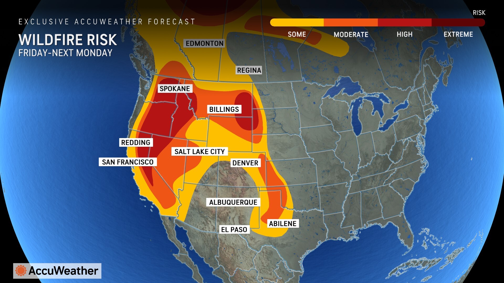
AccuWeather expert meteorologists warn that sudden and uneven changes in temperatures across the West could kick up winds and increase the risk of wildfires.
AccuWeather expert meteorologists say there is a high risk of wildfires in parts of California, Nevada, Oregon, Washington and Idaho over the holiday weekend.
Smoke from ongoing wildfires will be a concern for air quality in some areas of the West, especially in the Northwest, where the warmest conditions relative to the historical average are anticipated.
AccuWeather Forecast Graphics
Additional AccuWeather Resources:


