


AccuWeather meteorologists are available 24/7 to provide further insights and updates on evolving weather conditions. Please contact pr@accuweather.com during regular business hours, or support@accuweather.com or call AccuWeather’s Media Hotline at (814)-235-8710 at any time to arrange interviews with AccuWeather experts or to request the most updated graphics for print or broadcast.
Winds fuel wildfire risk in California; stormy week ahead for the East Coast
Dec. 10, 2024

> Severe thunderstorms expected along the Gulf Coast through Tuesday night
> Storms and gusty winds could lead to power outages along the East Coast from North Carolina to Maine Wednesday
> Lake-effect snow and bitterly cold air return to parts of the Great Lakes, Northeast and Midwest later this week
AccuWeather Global Weather Center – Dec. 10, 2024
AccuWeather expert meteorologists say a stormy pattern stretching across the United States has led to a high risk of wildfires in Southern California today, as well as the threat of severe thunderstorms along the Gulf Coast and into the Northeast this week.
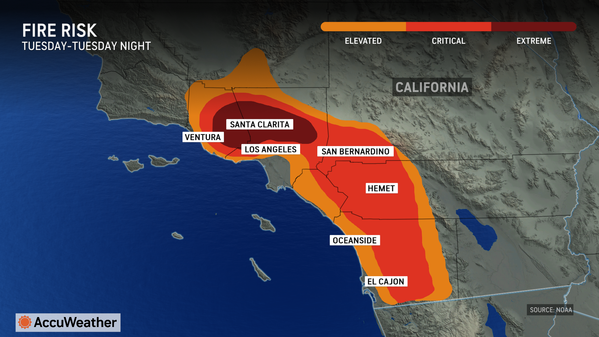
Wildfire threat in Southern California
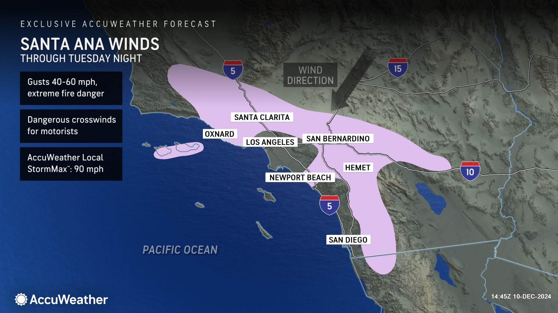
Santa Ana winds kicked up late Monday night and are forecast to continue through Tuesday night across portions of Southern California.
A fire that sparked in Malibu late Monday night has scorched more than 2,000 acres. AccuWeather Chief On-Air Meteorologist Bernie Rayno says there is an extreme fire risk in the region due to dry and gusty conditions through Tuesday evening.
“The fire risk will continue throughout the day, but winds later this afternoon and tonight will not be as strong as they were last night,” Rayno said. “The Santa Ana winds are expected to diminish tonight, but conditions will still be dry and breezy.”
AccuWeather expert meteorologists say a building area of high pressure across the Great Basin is the driving force behind the gusty winds. The rising pressure forces a rush of wind over the ridges, down the slopes and through the northeast-to-southwest-orientated valleys and canyons in Southern California.
Wind gusts from the northeast will range between 40-60 mph through Tuesday night, which is strong enough to break tree limbs, knock down power lines, and cause wind damage. The AccuWeather Local StormMax™ is 90 mph.
Because of the topography, much of downtown Los Angeles will be protected from the strong winds, but moderate gusts can reach all the way to the coast, such as in Oxnard and Newport Beach, California.
By the middle of the week, the area of high pressure will have moved well inland over the West, and the strong northeast winds produced by rising pressure in Southern California will ease. Breezes will pick up from the south and west by Thursday as a storm moves inland over the Pacific Northwest.
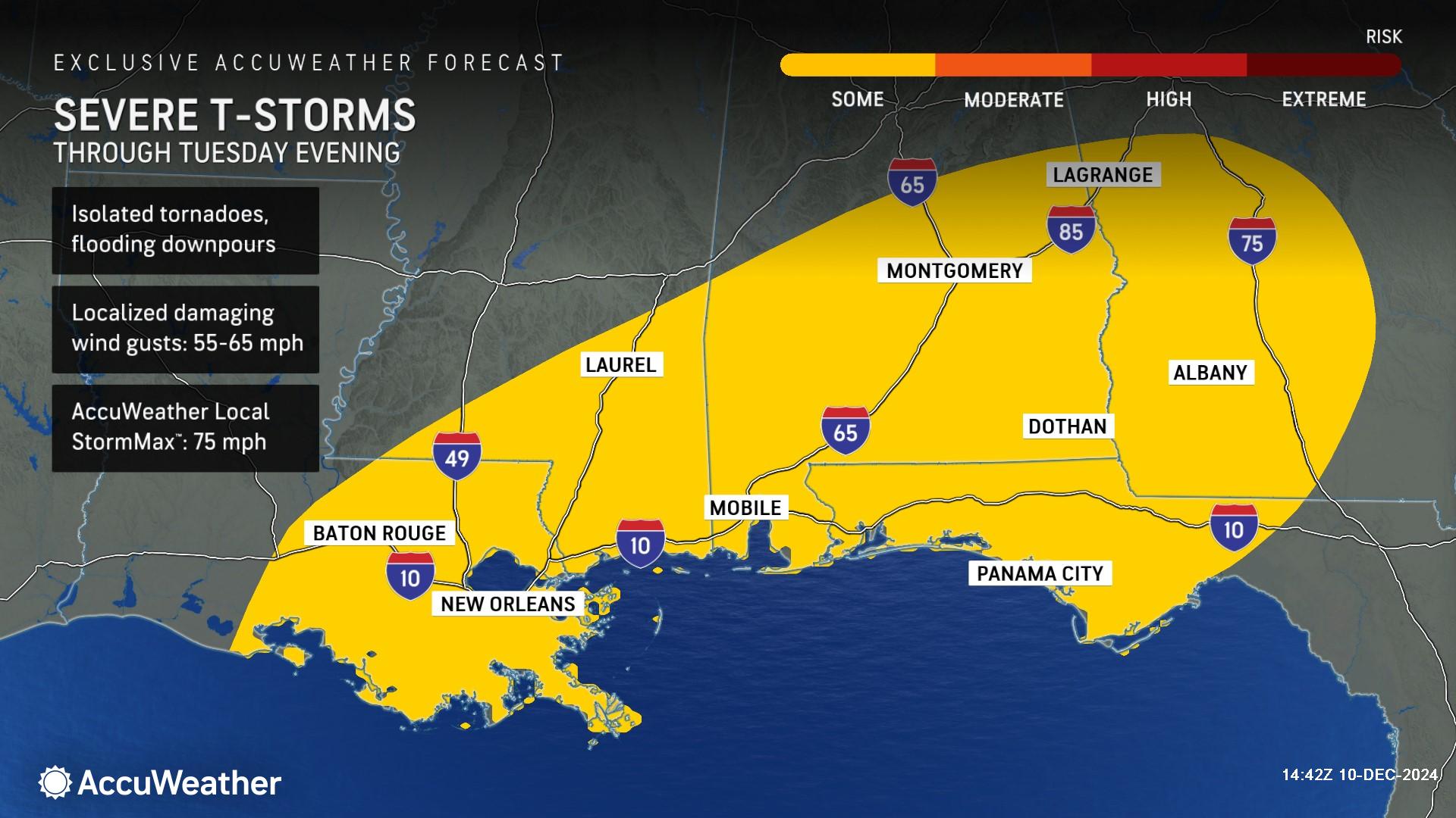
Severe weather threat along the Gulf Coast
AccuWeather expert meteorologists are forecasting thunderstorms to rumble through parts of southeastern Louisiana, southeastern Mississippi, central and southern Alabama, and southwestern Georgia through Tuesday evening.
There is a risk of flooding downpours, an isolated tornado or two, and wind gusts of 55-65 mph with an AccuWeather Local StormMax™ of 75 mph.
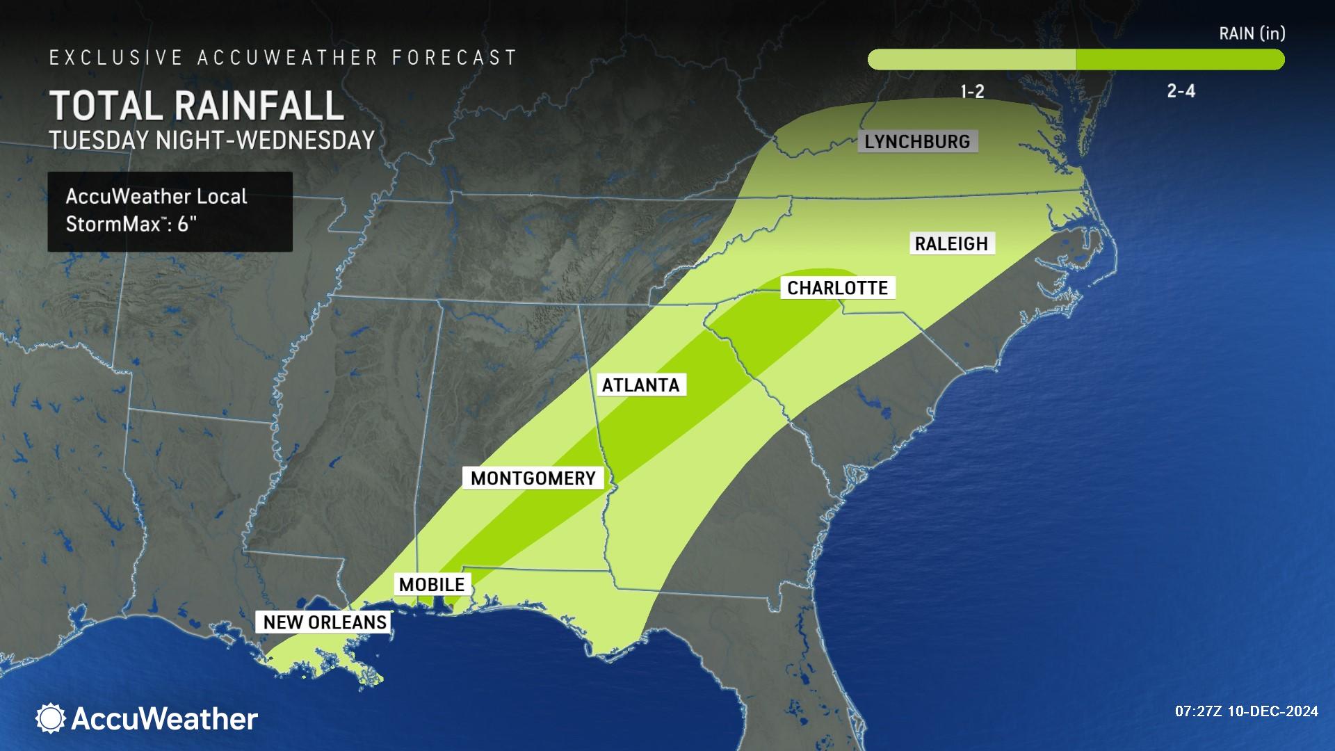
AccuWeather Meteorologist Grady Gilman says rainfall totals as high as 4 inches can occur across portions of the Southeast from southern Alabama into the Carolinas with an AccuWeather Local StormMax™ of 6 inches.
"A surge of mild and moist Gulf air will follow along and ahead of a wave of low pressure along a front pushing through the lower Mississippi Valley into the mid-Atlantic and up through the Northeast during the middle of this week," Gilman said.
Gusty storms and power outage risk along the East Coast
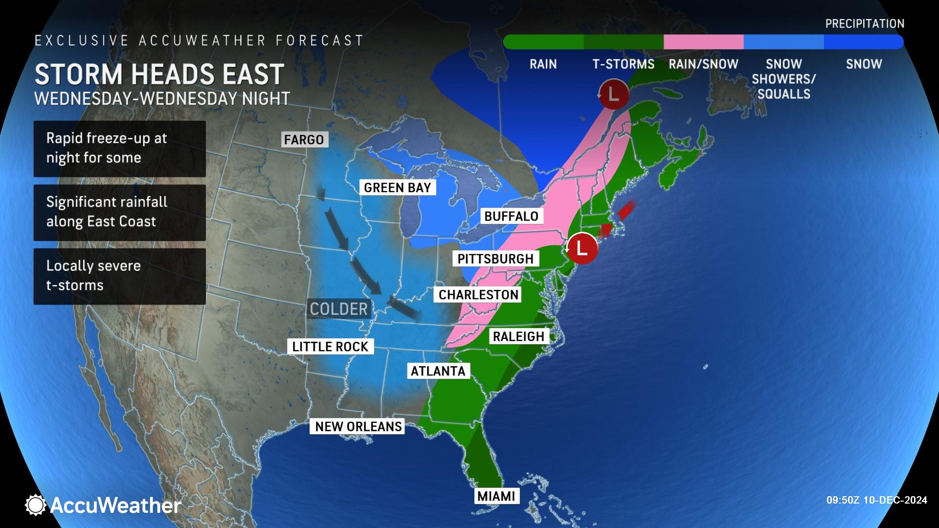
The storm will continue to gain intensity as it moves northward along a cold front Tuesday night into Wednesday.
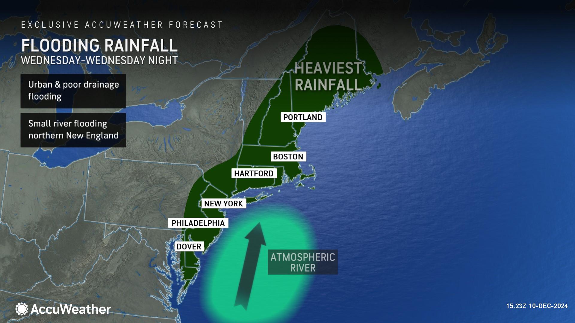
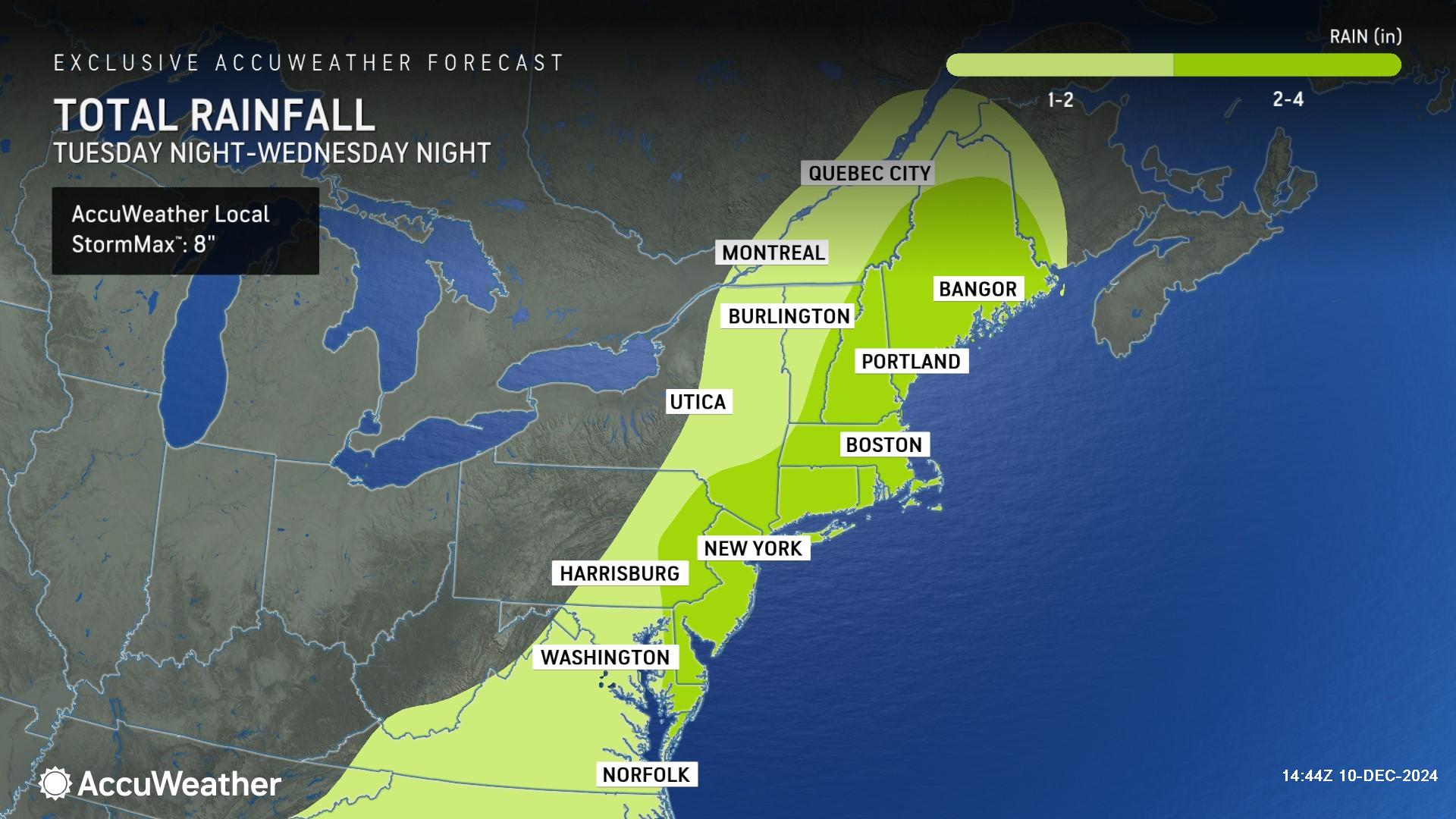
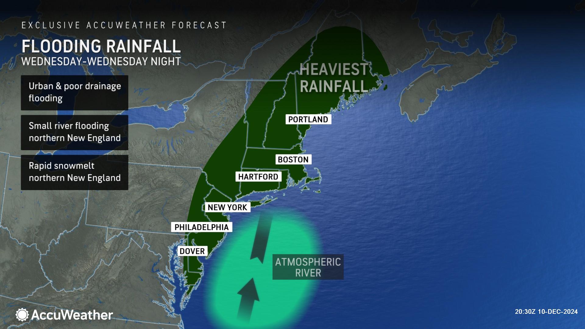
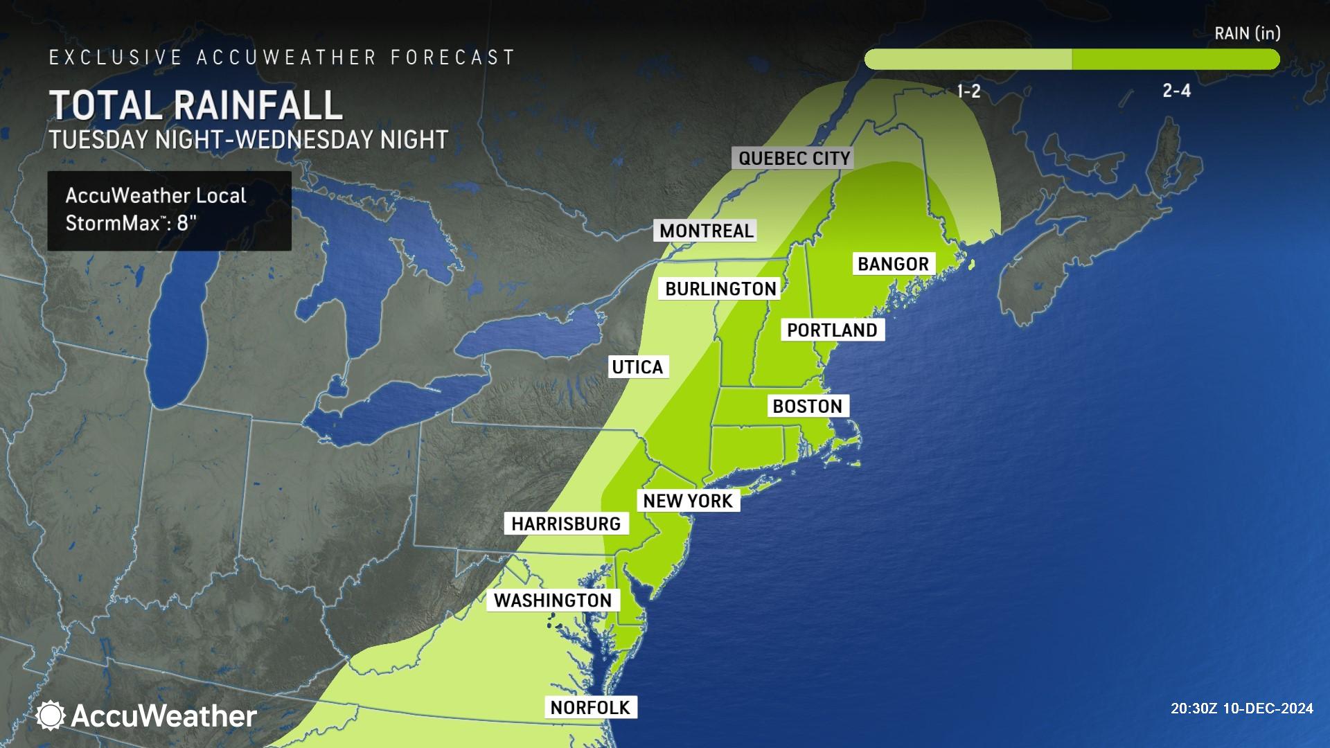
Mild air will surge northward ahead of the front, which will limit wintry precipitation as moisture arrives Tuesday night. Outside of Maine and Canada, even the mountainous terrain in the Northeast is expected to have plain rain Tuesday night. Heavy rain and temperatures above freezing will rapidly melt any existing snow on the ground and could cause flooding. Dense fog is also likely in some areas.
"After a cold and snowy start to December, there will be a concern for an increased flooding threat in areas with a deep snowpack already in place, especially in areas downwind of Lake Erie and Lake Ontario that were buried in feet of snow," Gilman said.
Rainy, windy and foggy conditions could cause travel issues through the region, especially along busy corridors of Interstate 95 and Interstate 81.
"Wednesday is shaping up to be a very wet day up and down the I-95 corridor from northern Florida all the way to Maine," AccuWeather Senior Meteorologist Bill Deger said. "Both the morning and evening commutes in cities such as Washington, Baltimore, Philadelphia, New York and Boston can be slowed by downpours, which can also cause localized flooding."
Rainfall totals of 2-4 inches are possible in parts of eastern Pennsylvania and eastern New Jersey through coastal New England Wednesday, with an AccuWeather Local StormMax™ of 8 inches.
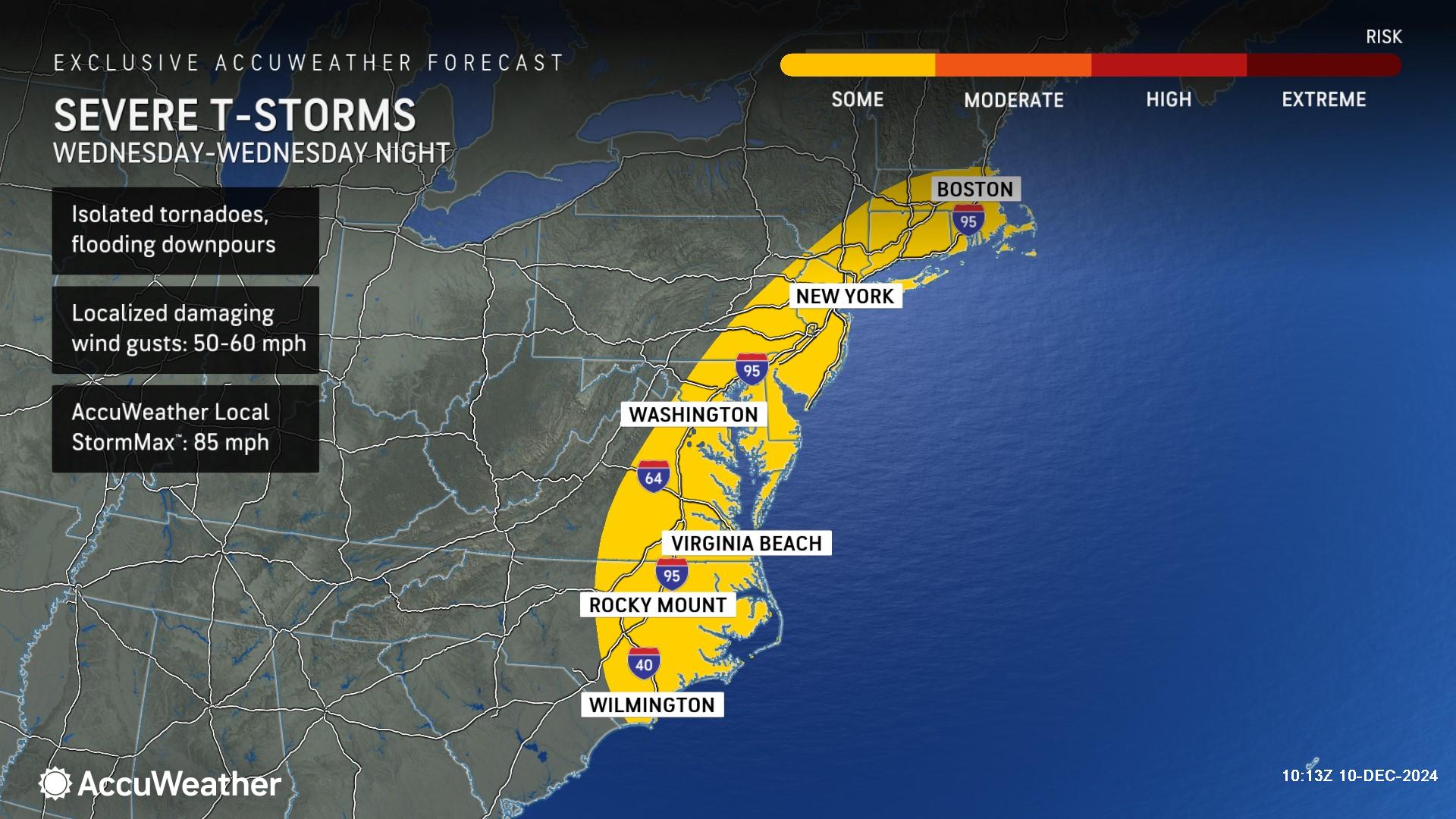
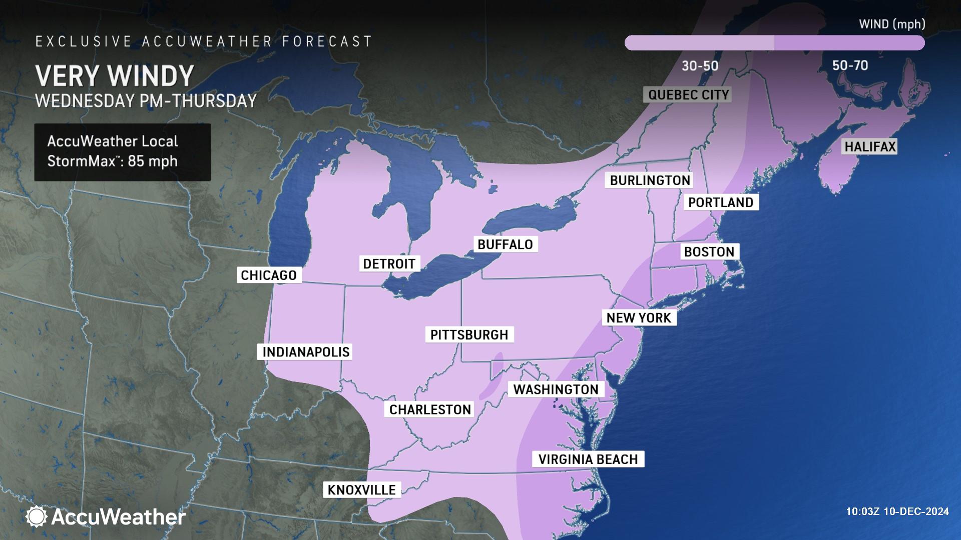
AccuWeather expert meteorologists say there is a risk of severe thunderstorms Wednesday from eastern North Carolina through Massachusetts, with the potential for flooding downpours, an isolated tornado or two, and wind gusts of 50-60 mph with an AccuWeather Local StormMax™ of 85 mph.
“An intense band of rain may develop with gusty winds that can really hamper travel during the afternoon and evening commutes on Wednesday from the Carolinas to southern New England,” AccuWeather Senior Meteorologist Alex Sosnowski said. “Thunder and lightning could accompany the intense rain and urban flooding potential.”
The rapidly strengthening storm could be designated as a bomb cyclone if the central pressure in the storm plunges 0.71 inches in 24 hours or less (24 millibars). It could do that as it takes a northerly track from the mid-Atlantic states to Quebec from Wednesday to Thursday.
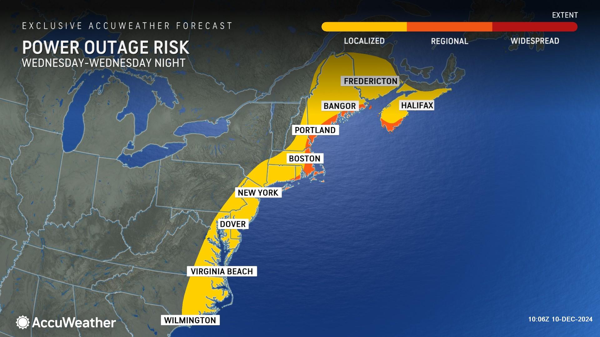
Due to the risk of gusty winds and severe thunderstorms, AccuWeather expert meteorologists say there is a risk of power outages across the East Coast from eastern North Carolina through Maine. Gusty winds could also blow away unsecured holiday decorations.
Snow and colder air behind the storms
Colder air rushing in on the back side of the storm could cause rain to change to snow in the interior Northeast and in the mountains. While amounts should be light, rapidly dropping temperatures could cause previously wet roads to become slushy and then icy.
"Arctic air will quickly arrive on the back side of the storm, and although not quite as cold nor as long-lasting as the previous cold air mass, there will be a concern for a rapid freeze-up across the northern mid-Atlantic and Northeast," Gilman said.
Winds will ramp up Wednesday afternoon into Thursday across the Northeast as the storm potentially evolves into a bomb cyclone.
"With the storm strengthening as it moves off to the north and east, there will be some gusty winds, both ahead of and behind the storm. That combined with the rain can lead to significant delays at airports," Deger said.
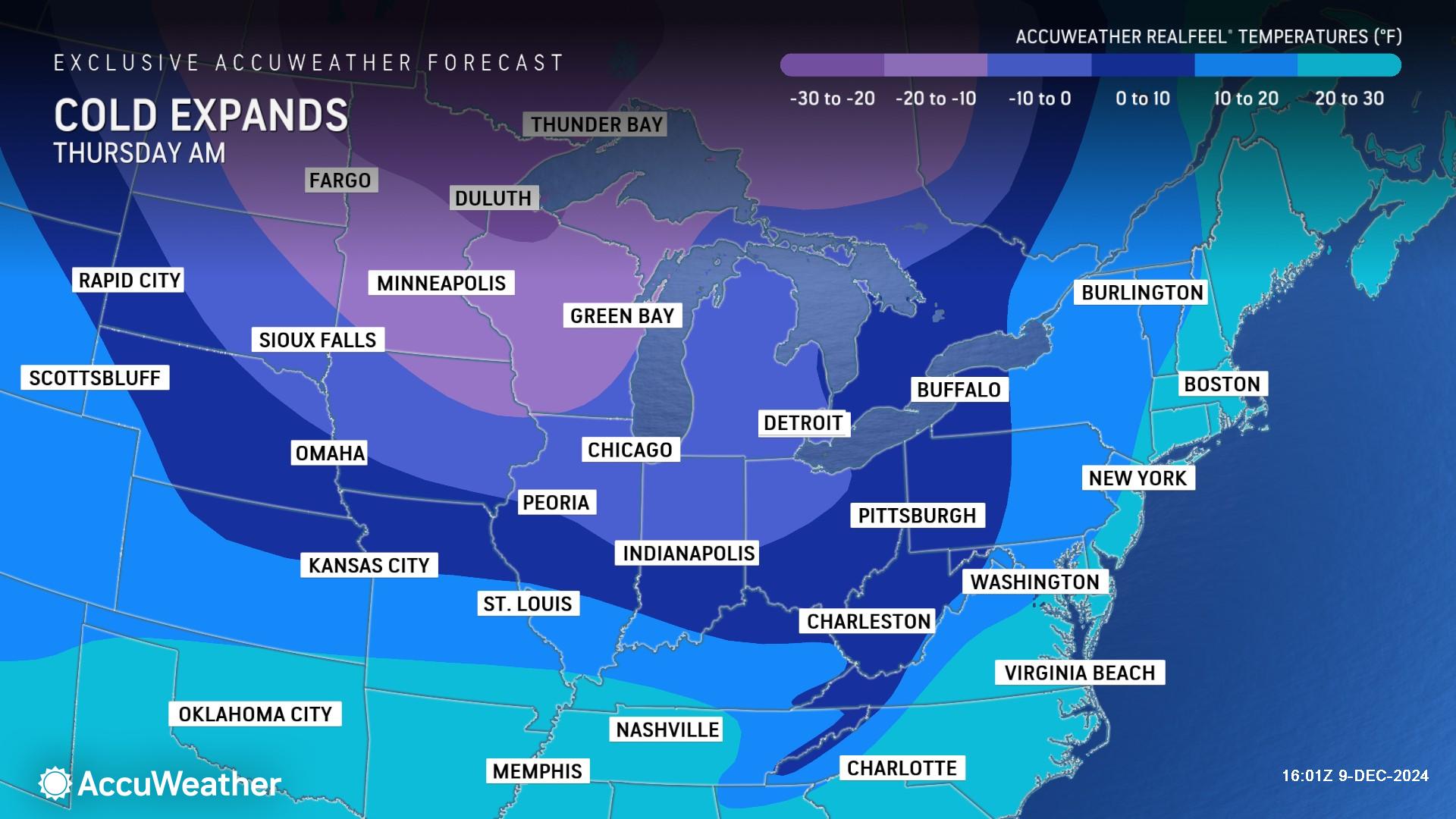
Arctic air will blast across the Midwest with subzero AccuWeather RealFeel® Temperatures and stiff northwesterly winds.
"This is true Arctic air, and it will be painful for those spending time outdoors,” Rayno said. "In the Upper Midwest, this is about as cold as it can get for this part of December.”
Temperatures will drop well below zero degrees across portions of the northern Plains and the Upper Midwest late Wednesday night and Thursday morning. On Thursday, highs will only be in the single digits in Minneapolis and the teens in Chicago with AccuWeather RealFeel® Temperatures below zero.
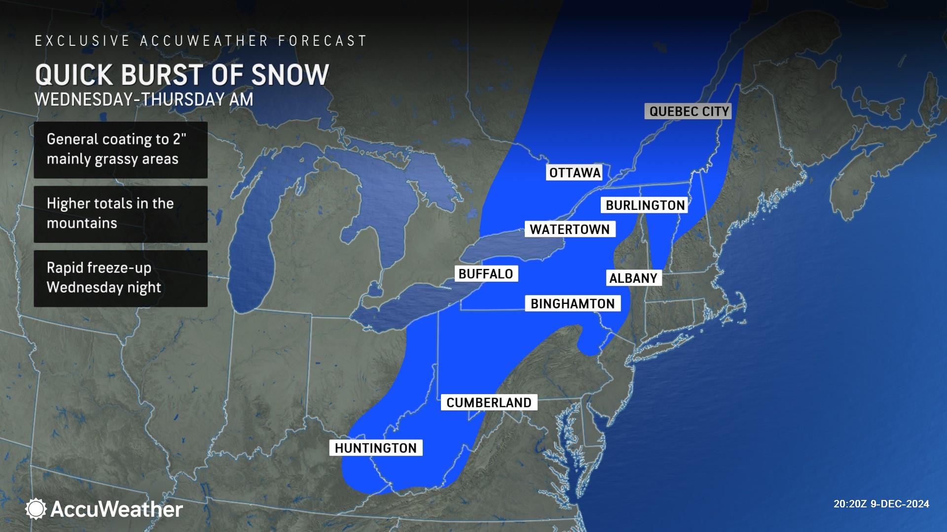
As the colder air begins to catch up with the back side of the storm in the East, rain may end as a period of accumulating snow as far to the south as parts of the southern Appalachians and the eastern Ohio Valley late Wednesday and Wednesday evening. Slick roads could cause travel issues in the region.
"Some areas, especially those higher in elevation, can get enough snow to make roads slushy, snow-covered, and even icy from the central Appalachians on north as temperatures drop quickly Wednesday night," Rayno said, "It is possible that steady snow brings a few inches to parts of western, central and northern New York and northern New England."
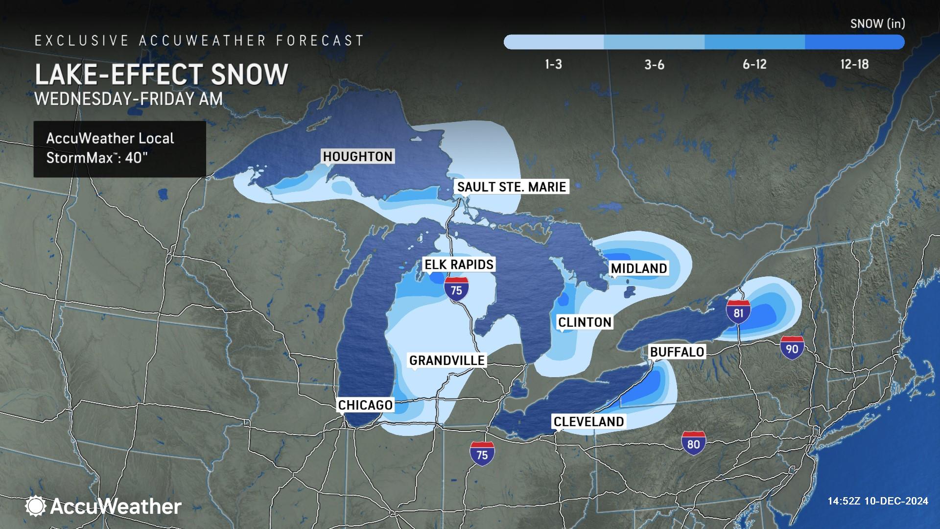
As temperatures tumble, lake-effect snow will return to the Great Lakes from Wednesday afternoon through Friday.
"Snowfall rates of 2-4 inches per hour can occur in the heaviest bands, which can easily overwhelm road crews, strand vehicles and shut down major highways," AccuWeather Meteorologist Brandon Buckingham said.
The AccuWeather Local StormMax™ for lake-effect snowfall starting Wednesday through Friday is 40 inches.
The Arctic blast and lake-effect snow event will be brief. The cold air is likely to ease by the weekend, with temperatures potentially rising above the historical average by early next week.

d
Additional AccuWeather Resources:
Canada storm with snow, Arctic blast to sweep across Midwest and Northeast
5 feet of lake-effect snow buries New York, shuts down highways
Lake-effect snow stalls travel for millions
What is lake-effect snow?
Meteorological winter versus astronomical winter


