AccuWeather meteorologists are available 24/7 to provide further insights and updates on evolving weather conditions. Please contact pr@accuweather.com during regular business hours, or support@accuweather.com or call AccuWeather’s Media Hotline at (814)-235-8710 at any time to arrange interviews with AccuWeather experts or to request the most updated graphics for print or broadcast.
Tropical Storm Could Impact the U.S. Gulf Coast this weekend; High Risk of Severe Thunderstorms and Flooding ahead of Election Day
Nov. 4, 2024
> Rounds of storms raising the risk of flooding in Oklahoma, Arkansas, Missouri and Kansas
> Tropical storm impacts are forecast to arrive by the end of this week in the central Gulf Coast
AccuWeather Global Weather Center – Nov. 4, 2024
AccuWeather expert meteorologists say parts of the central United States and Gulf coast region face another round of severe thunderstorms Monday, followed by the risk of flooding rainfall on Election Day, then the potential for tropical storm impactsarriving by the end of the week.
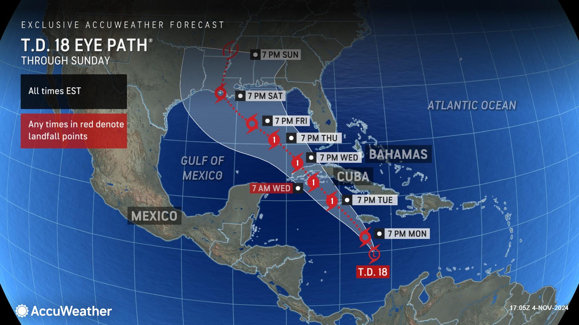
“This is going to be a very stormy and impactful week for millions of Americans,” said AccuWeather Chief Meteorologist Jon Porter. “The Gulf coast of Louisiana to Florida faces the greatest risk of tropical storm impacts later in the week and into the weekend.”
High Risk of Severe Thunderstorms Monday
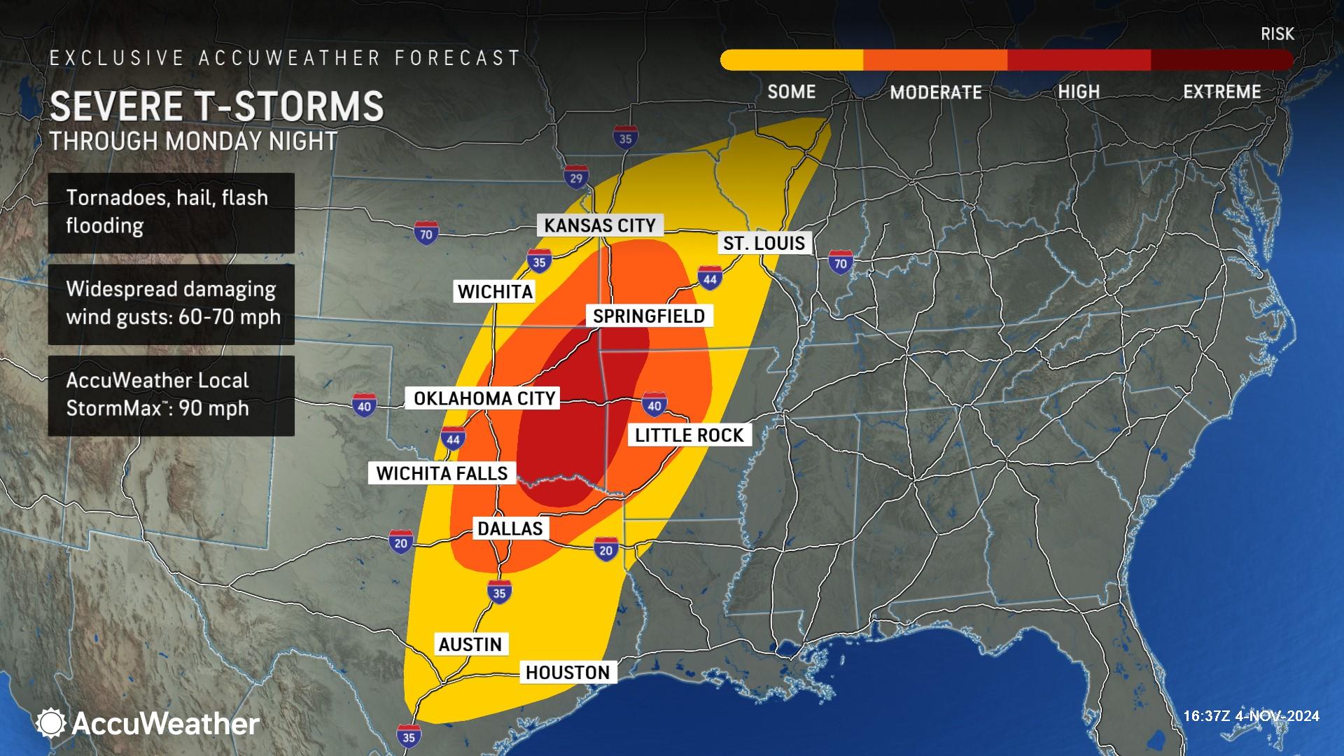
AccuWeather expert meteorologists warn that clashing air masses and an influx of moisture from the Gulf of Mexico will fuel a severe weather threat Monday from Texas through Illinois.
There is a high risk of severe thunderstorms that could produce tornadoes, hail, and flash flooding in parts of northeastern Texas, eastern Oklahoma, western Arkansas, southeastern Kansas, and southwestern Missouri.
Widespread damaging wind gusts up to 70 mph are possible in this area with an AccuWeather Local StormMax™ of 90 mph.
“The tornado threat could extend well into the night. Please be prepared with a way to receive warnings, like the AccuWeather app. Make sure your family knows where to go if a tornado warning wakes you up in the middle of the night,” said AccuWeather Senior Director of Forecasting Dan DePodwin. “We saw devastating tornado impacts in Oklahoma over the weekend. The second severe weather season is back in full force. Never let your guard down when there’s severe weather in the forecast. The clash of warm and cool air in the fall season can trigger dangerous thunderstorms and violent tornadoes.”
Rain & Flooding Risk on Election Day
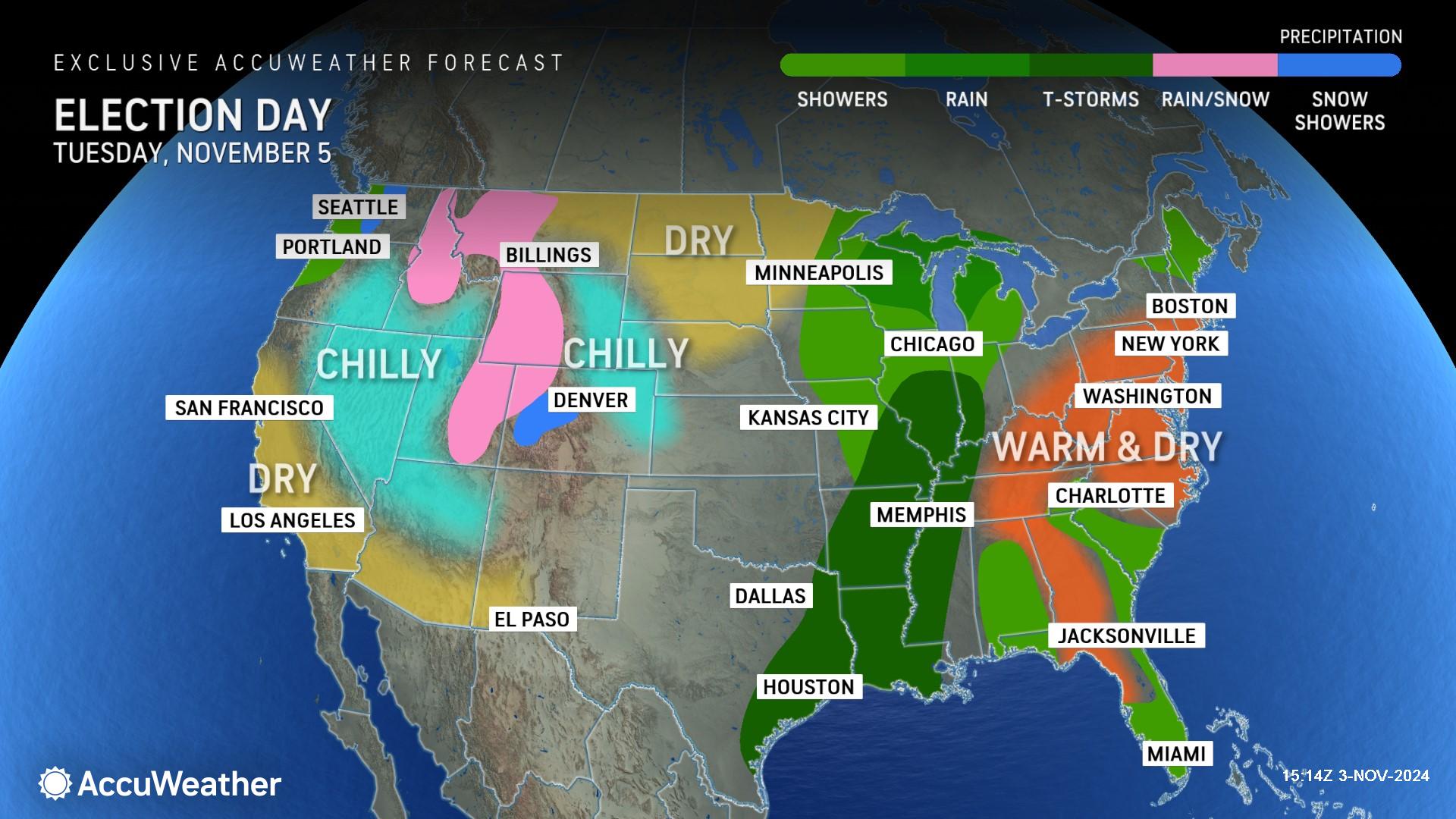
AccuWeather is forecasting thunderstorms to rumble across parts of the Gulf Coast and Mississippi Valley on Election Day, with rain and showers extending into the Great Lakes region.
“Rain is in the forecast on Election Day across the swing state of Michigan,” said AccuWeather Chief On-Air Meteorologist Bernie Rayno. “Temperatures will be near or above 70 degrees, which is much warmer than the historical average in the 50s.”
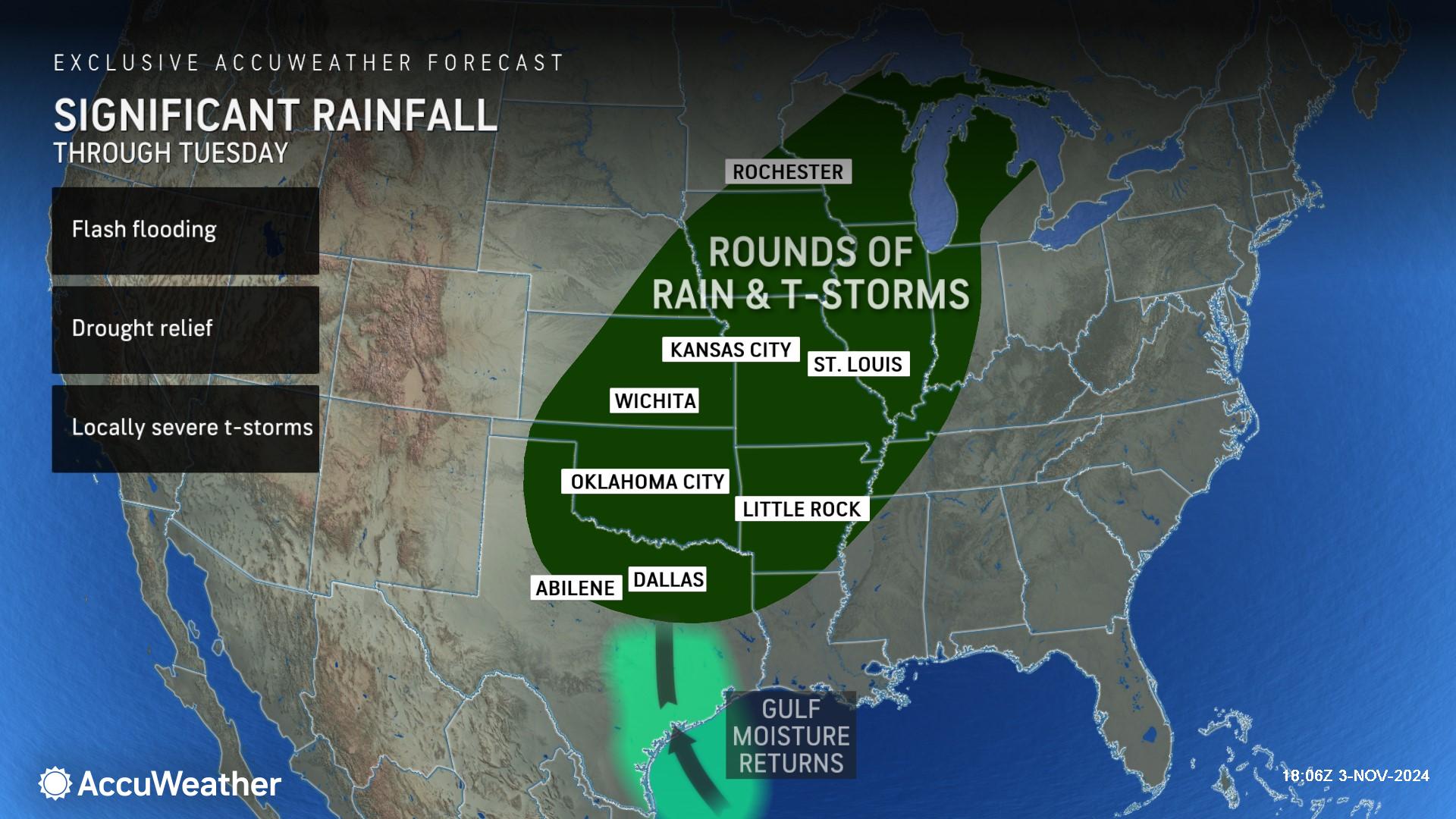
Multiple rounds of storms will continue into Tuesday bringing much-needed rain to the region, but it will also come at the risk of flashing flooding due to the hardened nature of the ground as a result of widespread drought.
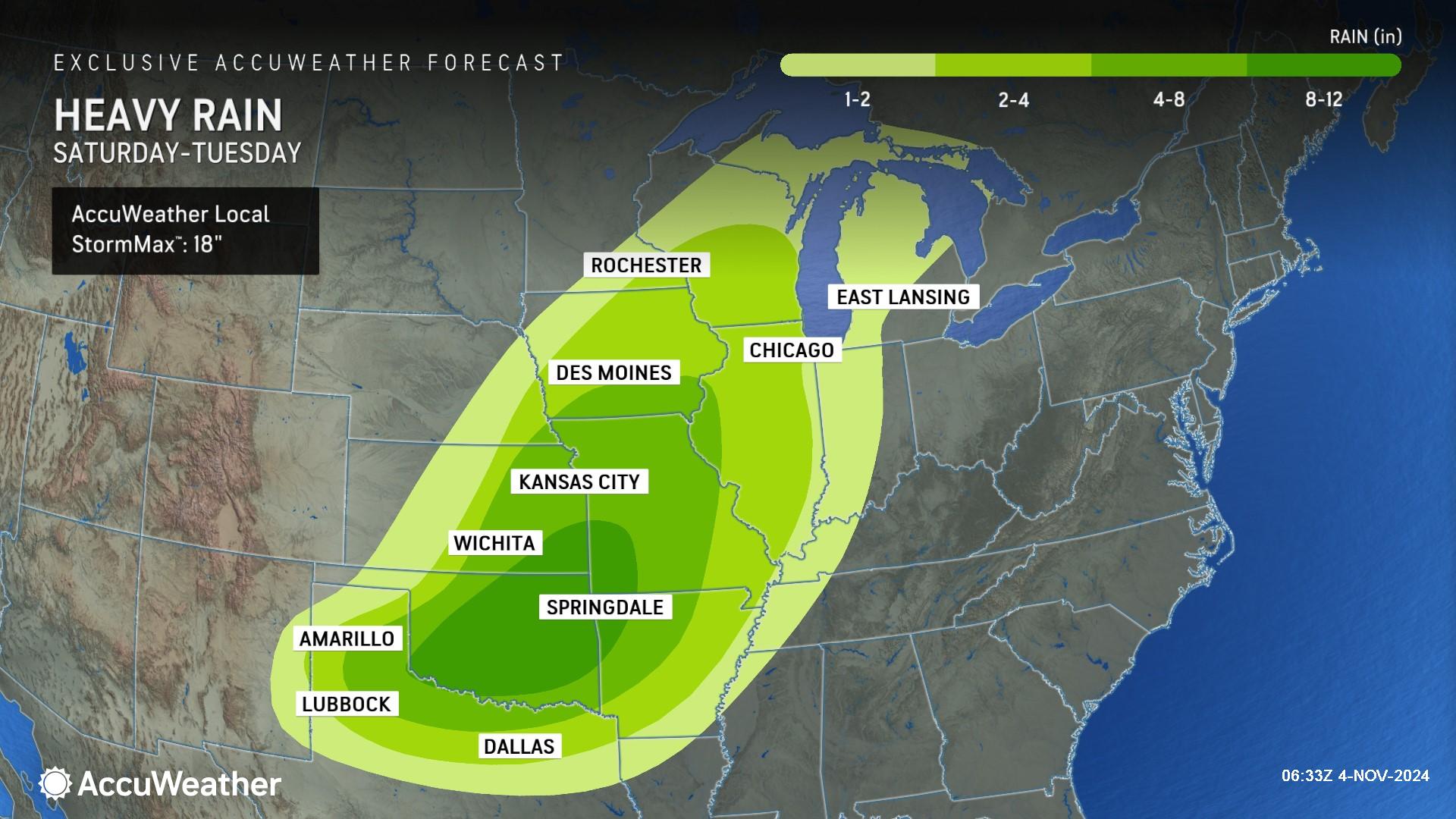
Through Tuesday, many areas from Texas to Iowa will receive several inches of rain, with a swath from southeastern Kansas and southwestern Missouri through northeastern and central Oklahoma expected to receive a total of 8-12 inches of rainfall with an AccuWeather Local StormMax™ of 18 inches.
AccuWeather is forecasting warm and dry conditions across much of the Northeast and mid-Atlantic on Election Day. Showers are possible in parts of New England, the Southeastand Florida.
A storm dipping down from the Northwest Tuesday will bring snow to parts of western Colorado and a wintry mix across parts of the Rockies and interior Northwest.
Gulf Coast on Alert for Tropical Impacts
AccuWeather hurricane experts say a brewing storm in the Caribbean Sea is expected to intensify into a tropical storm and then a hurricane as it moves toward Jamaica and then western Cuba early this week.
AccuWeather Chief Meteorologist Jon Porter says families and businesses along the U.S. Gulf Coast need to prepare for tropical storm impacts to arrive by the end of this week.
“AccuWeather warned the public about a late-season surge of tropical activity last Monday. We’re forecasting one to three named storms in the month of November due to the combination of warm waters and a favorable atmospheric setup,” said Porter. “We’ve had 16 named storms form in the Atlantic basin so far this season, plus the unnamed subtropical storm that made landfall in South Carolina. The numbers continue to add up. There are typically strong westerly winds this time of year over the Gulf of Mexico. That’s what directs any tropical storms to turn right and head toward Florida. If the winds are not that strong and the dip in the jet stream is a bit lower, that’s how this storm could end up in Louisiana.”
AccuWeather was the first known source to issue a track and impact forecast for this developing storm Saturday, one day before the National Hurricane Center. The next two names on the list of tropical storms for the 2024 Atlantic hurricane season are Rafael and Sara.
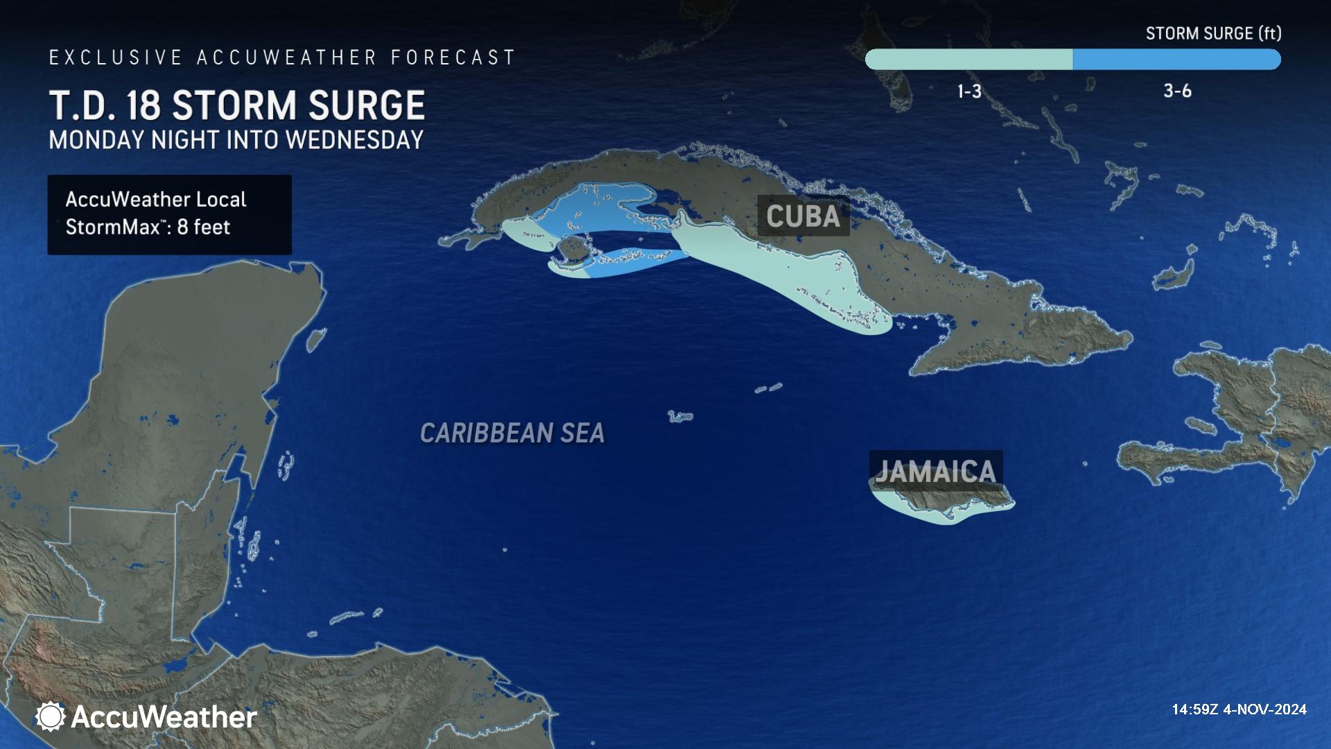
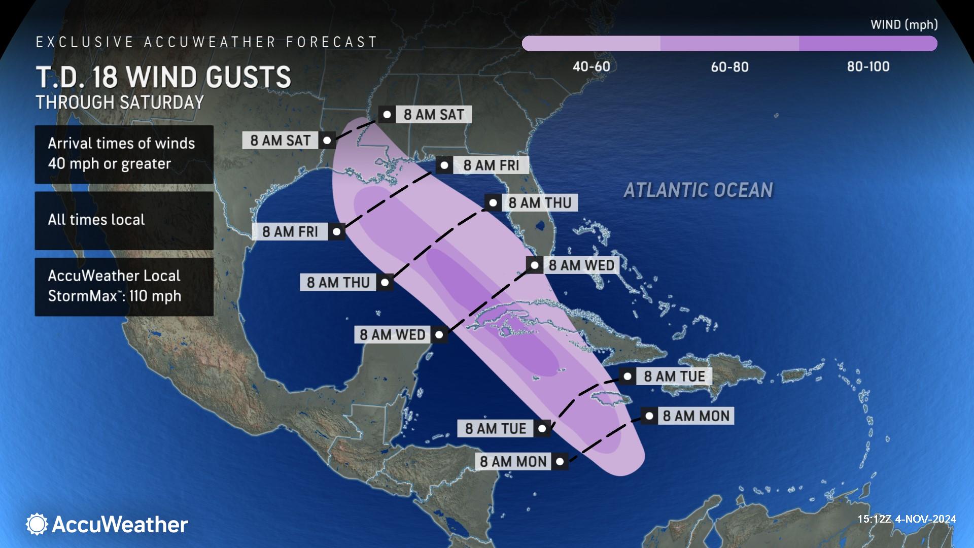
The storm is expected to track close enough to Jamaica and the Cayman Islands Monday night through Tuesday night to bring damaging winds, flooding rain, and 3-6 feet of storm surge.
AccuWeather is forecasting the storm to intensify into a Category 1 hurricane with maximum sustained winds of 74-95 mph on the Saffir-Simpson Hurricane Wind Scale before making landfall in western Cuba Wednesday.
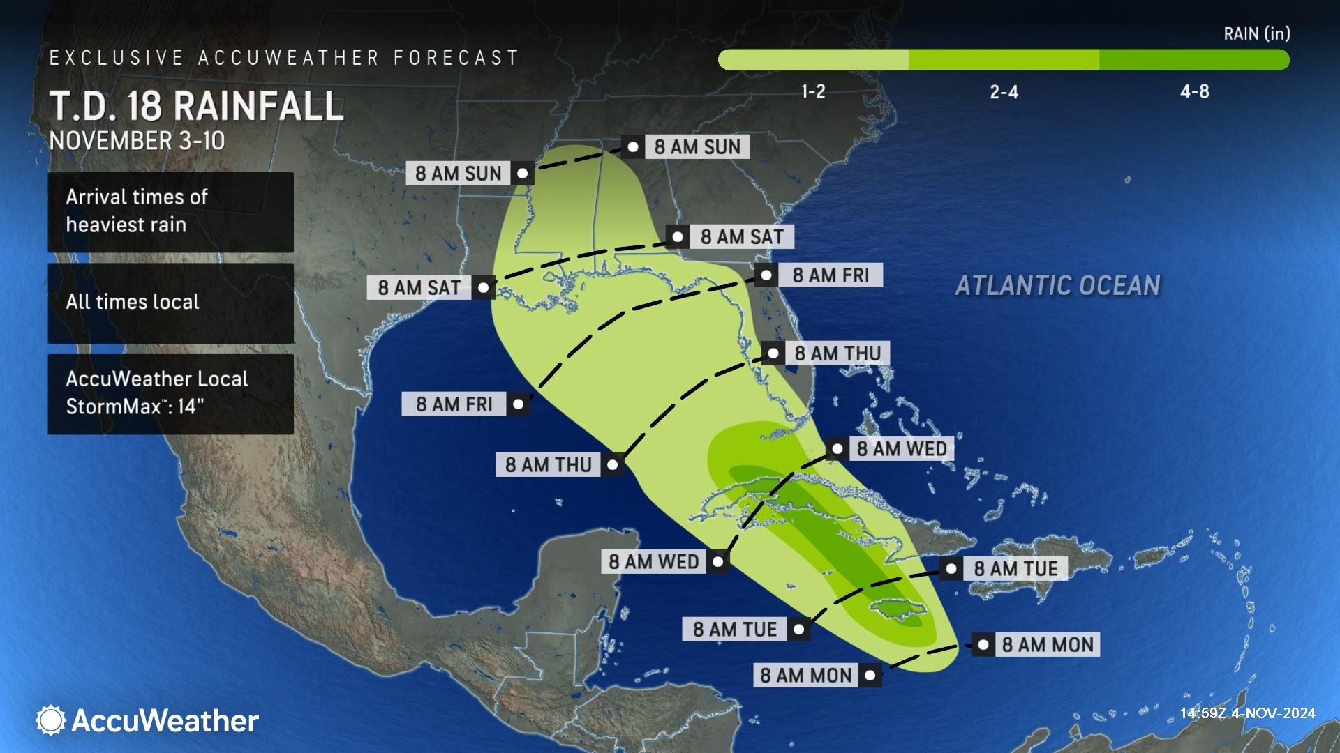
A wide swath of 1-2 inches of rain is expected to occur across Jamaica northward into Cuba. Heavier rain of 4-8 inches can occur close to the track of the storm over western Cuba and central Jamaica with an AccuWeather Local StormMax™ of 14 inches in the highest terrain.
A small area near where the storm makes landfall in Cuba could experience higher gusts of 80-100 mph with an AccuWeather Local StormMax™ of 110 mph. These winds can bring down trees and power lines and cause damage to infrastructure.
AccuWeather hurricane experts say a dip in the jet stream over the Southwest and an area of high pressure off the East Coast will determine where this storm eventually makes landfall along the U.S. Gulf coast.
“We’ll be dealing with a hurricane before this reaches the Gulf of Mexico on Wednesday. This is a rare storm track for the month of November,” Rayno said. “There’s an area of high pressure off the coast of the Carolinas. Steering winds around the area of high pressure are clockwise, so we’re going to get a southeasterly wind pushing this storm to the west, northwest. The big question is the strength of a dip in the jet stream over Texas. If it’s strong enough and far enough east, the storm will encounter the west-southwest winds, which would turn the storm track to the right into the central Gulf Coast. If the dip in the jet stream is far to the west and weaker, the storm will move due northwest.”
Rayno said the storm is expected to lose at least some wind intensity as it approaches the U.S. coastline by the end of the week.
“Wind shear is expected to increase in the Gulf of Mexico later this week. Water temperatures in the Gulf are also a bit cooler than they are in the Caribbean. That’s why we expect this forecast hurricane in the Gulf to lose wind intensity and make landfall as a tropical storm this weekend.” Rayno said.
Also of concern, while not appearing likely at this stage, AccuWeather expert meteorologists cannot rule out a surge of moisture coming northward into the southern Appalachians ahead of this storm should it track far enough east. While the type of rainfall amounts Helene brought is unlikely, there could be enough moisture to renew flooding concerns in the region.
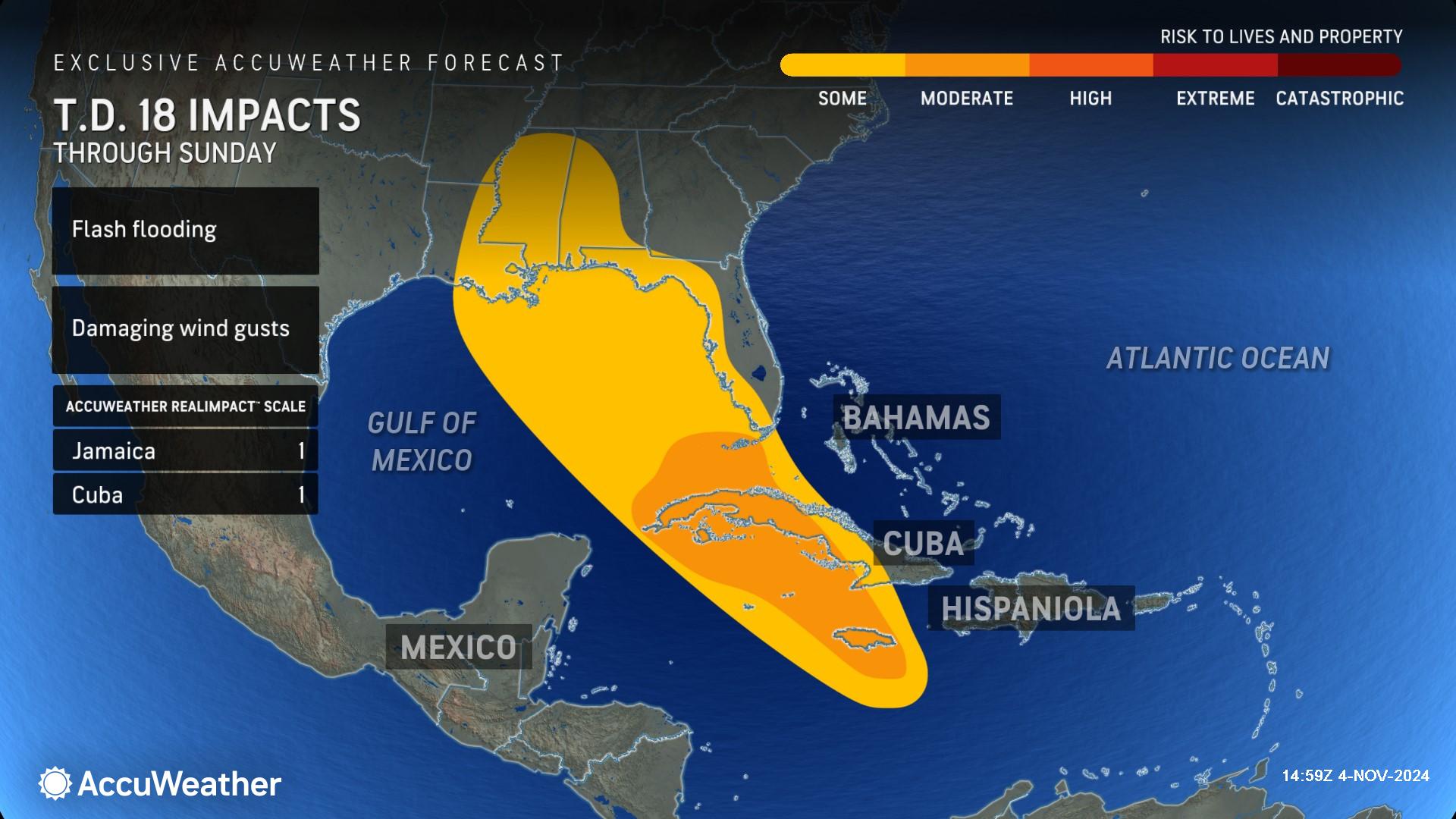
Due to the rain and wind, the AccuWeather RealImpact™ Scale for Hurricanes is a 1 for Jamaica and Cuba.
A 1 on the AccuWeather RealImpact™ Scale for Hurricanes warns of localized flooding, damage to unanchored mobile homes, localized power outages, and coastal inundation resulting in some property damage
In contrast to the Saffir-Simpson Hurricane Wind Scale, which classifies storms by wind speed only, the AccuWeather RealImpact™ Scale is based on a broad range of important factors. In order to better communicate a more comprehensive representation of the potential impact of a storm on lives and livelihoods, the scale covers not only wind speed, but also flooding rain, storm surge and economic damage and loss. Some of these hazards, such as inland flooding and storm surge in many storms, result in more deaths and economic loss than wind.
AccuWeather Forecast Graphics
Additional AccuWeather Resources:
Tropical storm likely to brew in Caribbean, may reach US
Severe storms, flooding to impact central US through Election Day


