AccuWeather meteorologists are available 24/7 to provide further insights and updates on evolving weather conditions. Please contact pr@accuweather.com during regular business hours, or support@accuweather.com or call AccuWeather’s Media Hotline at (814)-235-8710 at any time to arrange interviews with AccuWeather experts or to request the most updated graphics for print or broadcast.
Six potential tropical threats lurking in the Atlantic basin; AccuWeather issues Eye Path for Tropical Rainstorm off the East Coast
Sept. 5, 2024
AccuWeather Global Weather Center – Sept. 5, 2024
Following a historic lull in tropical activity in August with no named storms, AccuWeather expert meteorologists are now closely monitoring six potential tropical threats that might bring impacts to the United States and Atlantic Canada.
Flooding concerns along the Gulf Coast & Southeast
A slow-moving storm that has meandered from the Gulf of Mexico to Texas over the Labor Day holiday weekend has been dubbed a tropical rainstorm by AccuWeather expert meteorologists to raise public awareness about the potential of flooding in parts of the Lone Star state.
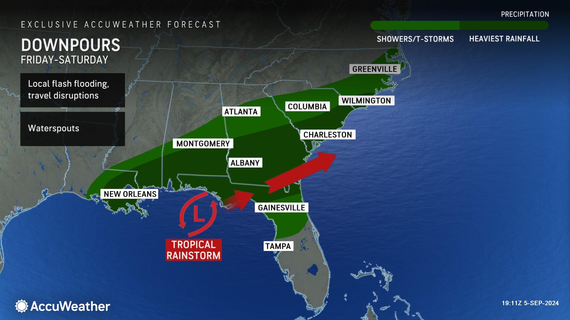
This tropical rainstorm is already responsible for several incidents of flash flooding in Texas and is expected to crawl eastward along the upper Gulf coast into the end of the week with torrential rain and locally severe thunderstorms.
"There are concerns that this tropical rainstorm could have enough time to evolve into a tropical depression or named tropical storm before pushing onshore along the central Gulf coast late in the week," said AccuWeather Lead Hurricane Expert Alex DaSilva. "The time spent over the warm Gulf of Mexico waters will be limited and stiff breezes above the tropical rainstorm could prevent an official name designation based on wind intensity.”
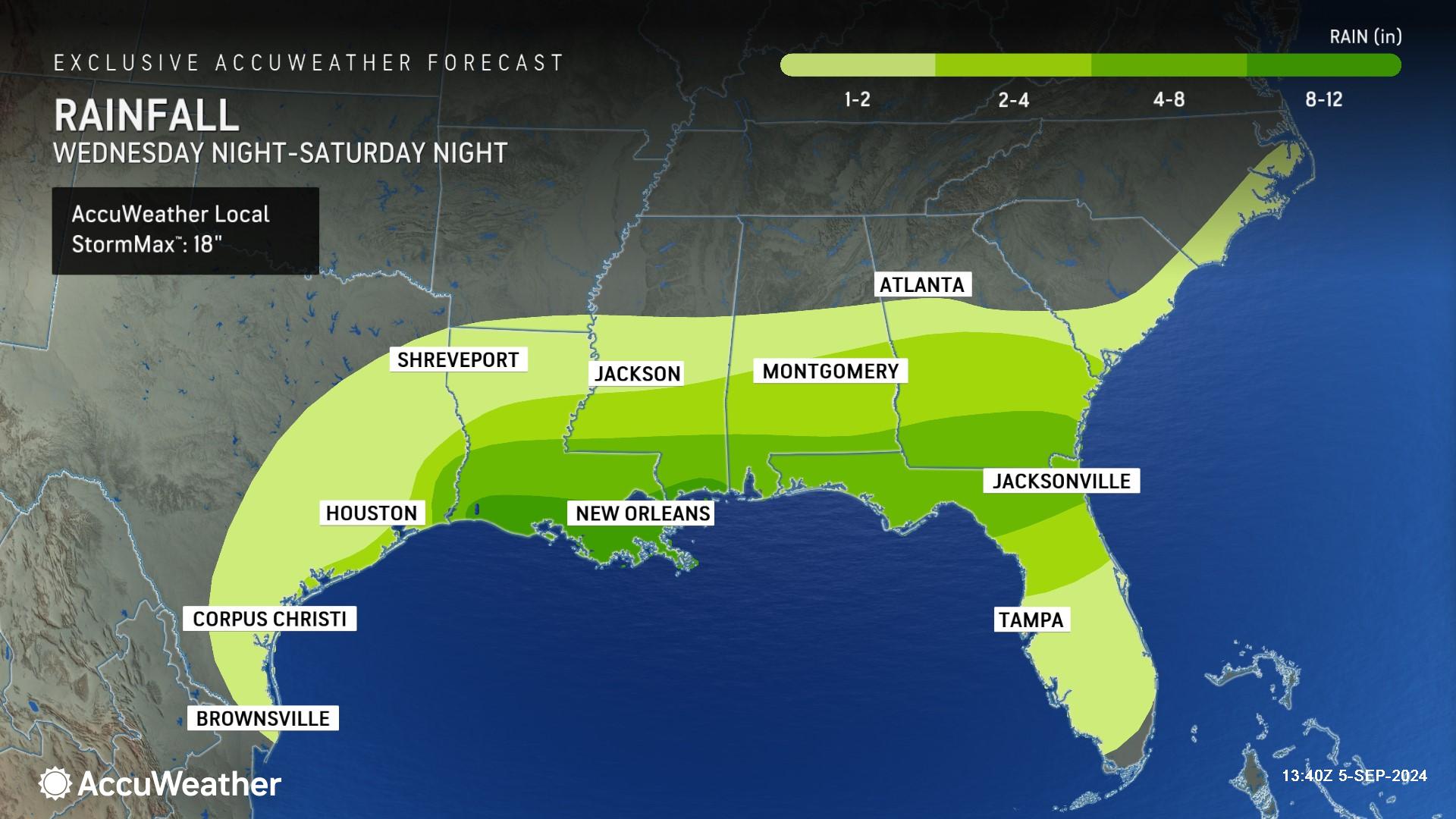
AccuWeather expert meterologists say a widespread zone of 4-8 inches of rainfall is possible through Saturday night along the Gulf coast and northern Florida. Parts of coastal Louisiana and Mississippi could receive 8-12 inches of rainfall. The AccuWeather Local StormMax™ is 18 inches.
The risk for flash flooding and travel disruptions will extend from central Texas to northern Florida and southern Georgia into the weekend.
Tropical rainstorm off the East coast
AccuWeather expert meteorologists are also monitoring another brewing threat several hundred miles off the mid-Atlantic coast.
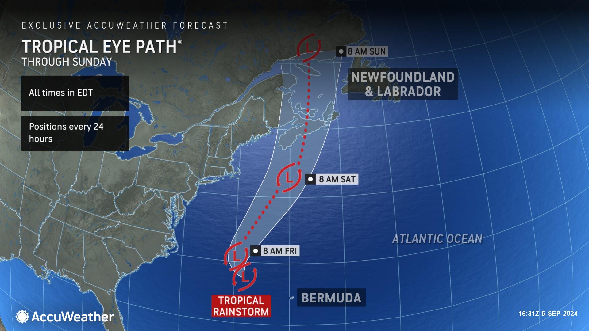
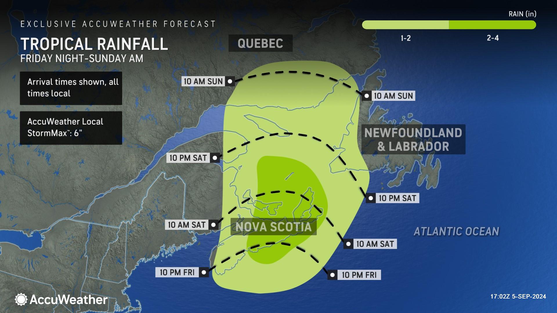
With the center of that circulation becoming better organized and centered more with thunderstorm activity, AccuWeather has dubbed this cluster of storms as a tropical rainstorm as well. An AccuWeather Forecast Eye Path® was first issued Thursday to alert families, businesses and leaders along the East coast and in Atlantic Canada about potential impacts.
"This budding system has the potential to become a tropical depression or named tropical storm prior to pushing onshore in Atlantic Canada this weekend," DaSilva said.
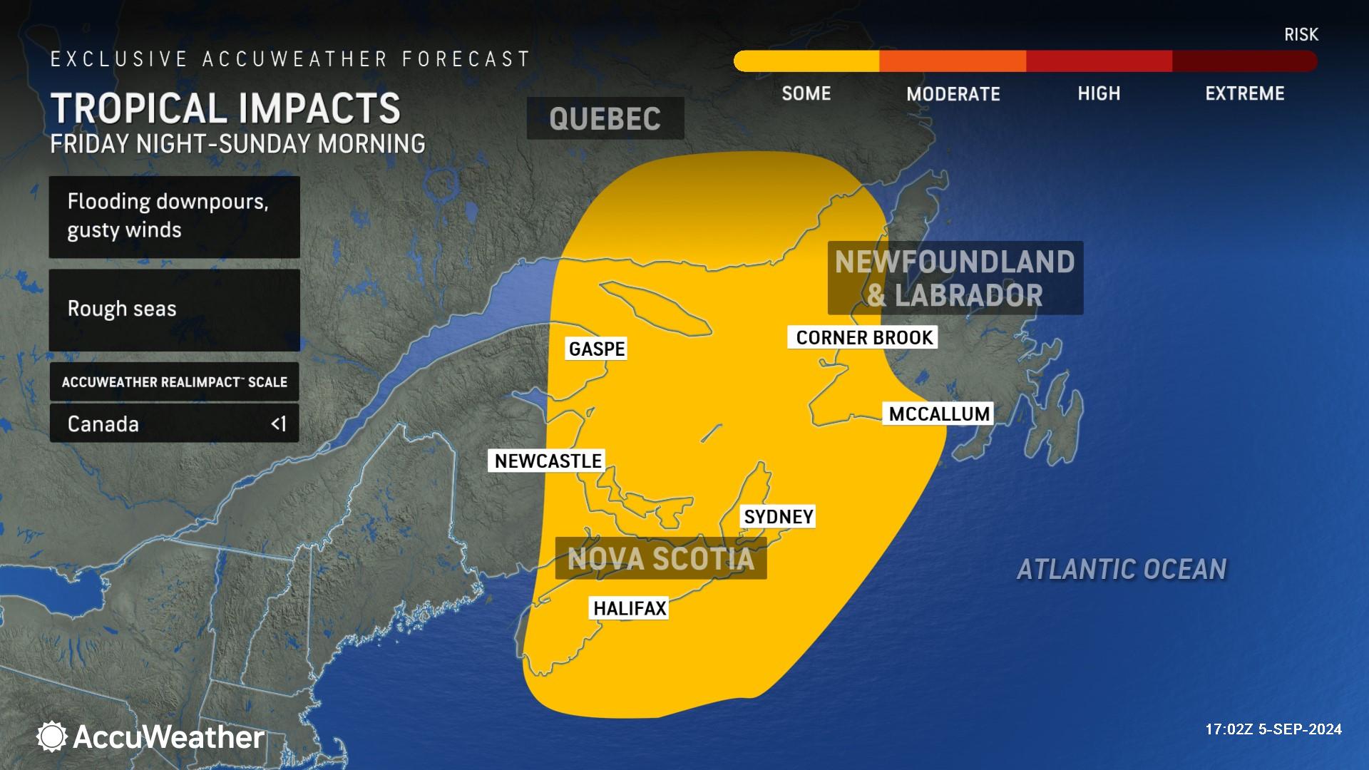
The main impacts will be a general 2-4 inches of rain that can trigger localized flooding and wind gusts of 40-60 miles per hour that can lead to power outages focused mainly on New Brunswick. The AccuWeather StormMax™ rainfall is 6 inches and StormMax wind gust is 70 mph.
Four additional areas to watch for tropical development
Following a long lull in the tropics without a named storm that hasn’t happened in decades, AccuWeather expert meteorologists are now monitoring four additional areas for potential tropical development within the next week.
The patches of potential tropical trouble extend from just off the coast of Africa to the Caribbean and include two separate areas with a medium chance of development within the next seven days.
AccuWeather expert meteorologists say one area with a medium risk over the central Atlantic may organize enough to become a tropical depression or storm from Friday to Sunday as it drifts westward.
A separate medium-risk area currently drifting westward across the Caribbean is not likely to organize and strengthen this week. However, it could escalate as it reaches southwestern Gulf of Mexico waters early next week.
"Should this upcoming southwestern Gulf feature become a tropical depression or tropical storm next week, it will be a question of steering breezes at the time," said AccuWeather Chief On-Air Meteorologist Bernie Rayno. "These breezes may direct it westward into Mexico or perhaps allow it to drift northward and enter the bathtub of warm water over the central Gulf."
Another area with a risk of development is being tracked as it travels to the northeast of the Caribbean from late this week to this weekend. The chance of this system organizing into a tropical depression or tropical storm is low.
The next two names on the list of tropical storms for the 2024 Atlantic hurricane season are Francine and Gordon.
Why have the tropics been so quiet?
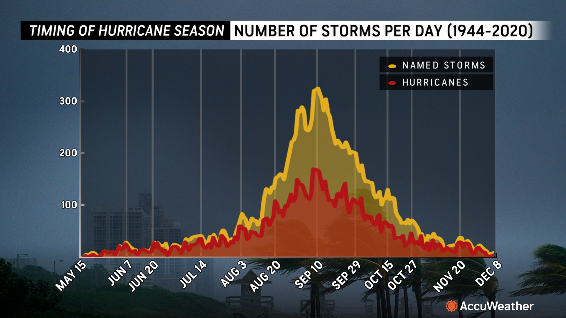
The 2024 Atlantic hurricane season has fallen below average pace despite the record-shattering 165-mph Category 5 Hurricane Beryl in July.
"The lull in tropical depressions, tropical storms and hurricanes since Ernesto from Aug. 13 through Sept. 3, has not been witnessed since the 1968 season," said AccuWeather Chief Meteorologist Jonathan Porter.
La Niña was expected to be a major player at this point of the season, but it has been much slower to evolve and influence the Atlantic hurricane season.
Other factors, such as dry, dusty air from Africa and widespread wind shear, have also worked to limit tropical activity.
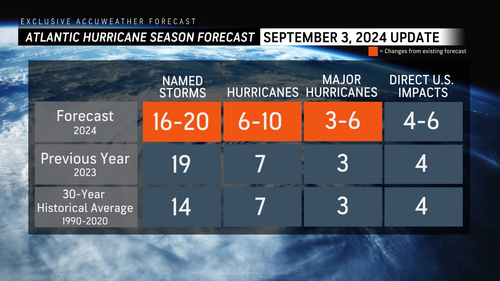
Conditions are expected to become more favorable for tropical storm and hurricane development as September progresses, but AccuWeather has lowered its initial forecast of 20-25 named storms to 16-20.
AccuWeather is the first of any sources to lower numbers from an anticipated highly active hurricane season for 2024.
Porter stated that an above-historical average number of named systems is still anticipated, with six to 10 hurricanes in total compared to the average of seven. The historical average number of named storms in the Atlantic hurricane season is 14.
"People should not let their guard down based on what has been going on since mid-August," Porter said. "It just takes one storm to lead to great risk to lives and property."
Porter says the extremely warm waters across much of the Atlantic basin can foster rapid intensification, which is a major public safety concern near coastal cities. The devastating impacts from Hurricane Ian in 2022 are a prime example of the dangers and concerns of rapid intensification.
AccuWeather Forecast Graphics
Additional AccuWeather Resources:
Several tropical threats lurk in Atlantic amid historic lull
AccuWeather Reduces Forecast for Number of Named Storms and Hurricanes During 2024 Atlantic Hurricane Season
Hurricane Tracking & Storm Radar


