AccuWeather meteorologists are available 24/7 to provide further insights and updates on evolving weather conditions. Please contact pr@accuweather.com during regular business hours, or support@accuweather.com or call AccuWeather’s Media Hotline at (814)-235-8710 at any time to arrange interviews with AccuWeather experts or to request the most updated graphics for print or broadcast.
Devastating storm surge, flash flooding, wind damage and tornadoes as Hurricane Milton approaches the Gulf coast of Florida
Oct. 9, 2024
WATCH RECORDING OF WEDNESDAY MEDIA BRIEFING WITH ACCUWEATHER LEAD HURRICANE EXPERT ALEX DASILVA
4Vw!Rs4#
REGISTER FOR LIVE MEDIA BRIEFING + Q&A WITH ACCUWEATHER EXPERT METEOROLOGISTS THURSDAY AT 8:30 AM EDT
AccuWeather Global Weather Center – Oct. 9, 2024
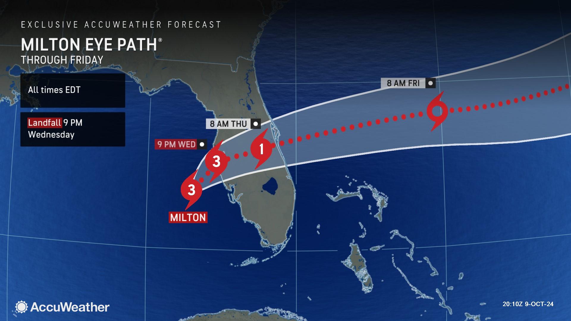
“Hurricane Milton continues to move rapidly toward the west coast of Florida at 17 mph. Over the last several hours, the storm has been moving more to the north than it has to the east, which is enabling the storm to gain latitude and draw closer to Tampa Bay. Over the coming hours, the storm can take a turn more toward the east, as the storm approaches the coast. The location at which the storm moves to the east is extremely critical in terms of defining where the worst of the devastating storm surge occurs,” said AccuWeather Chief Meteorologist Jon Porter. “AccuWeather experts been forecasting a landfall point near Anna Maria Island on the far southern part of Tampa Bay at 9 p.m. EDT Wednesday. The AccuWeather landfall location is some 25 miles north of the National Hurricane Center and other known sources. AccuWeather hurricane experts are concerned that should the storm continue moving with a significant northerly component for an extended period, the landfall point could even be farther north than the current AccuWeather forecast, closer to St. Petersburg, which would alarmingly result in maximum damage in parts of Tampa Bay. Conversely, should an eastward motion occur sooner, the storm surge could be greatly reduced in Tampa Bay, with increased storm surge impacts farther south along the coast from Bradenton and Sarasota toward Venice.”
AccuWeather Lead Hurricane Expert Alex DaSilva says Milton will bring life-threatening and potentially historic hurricane impacts to the Florida Gulf Coast, at least from Sarasota southward and perhaps into the Tampa Bay region that haven’t been seen in a century.
“We don’t want people to be fooled by the fact that Hurricane Milton is expected to have slightly lower wind intensity at landfall. This is a very powerful major hurricane. Milton is growing in size before making landfall,” said DaSilva.
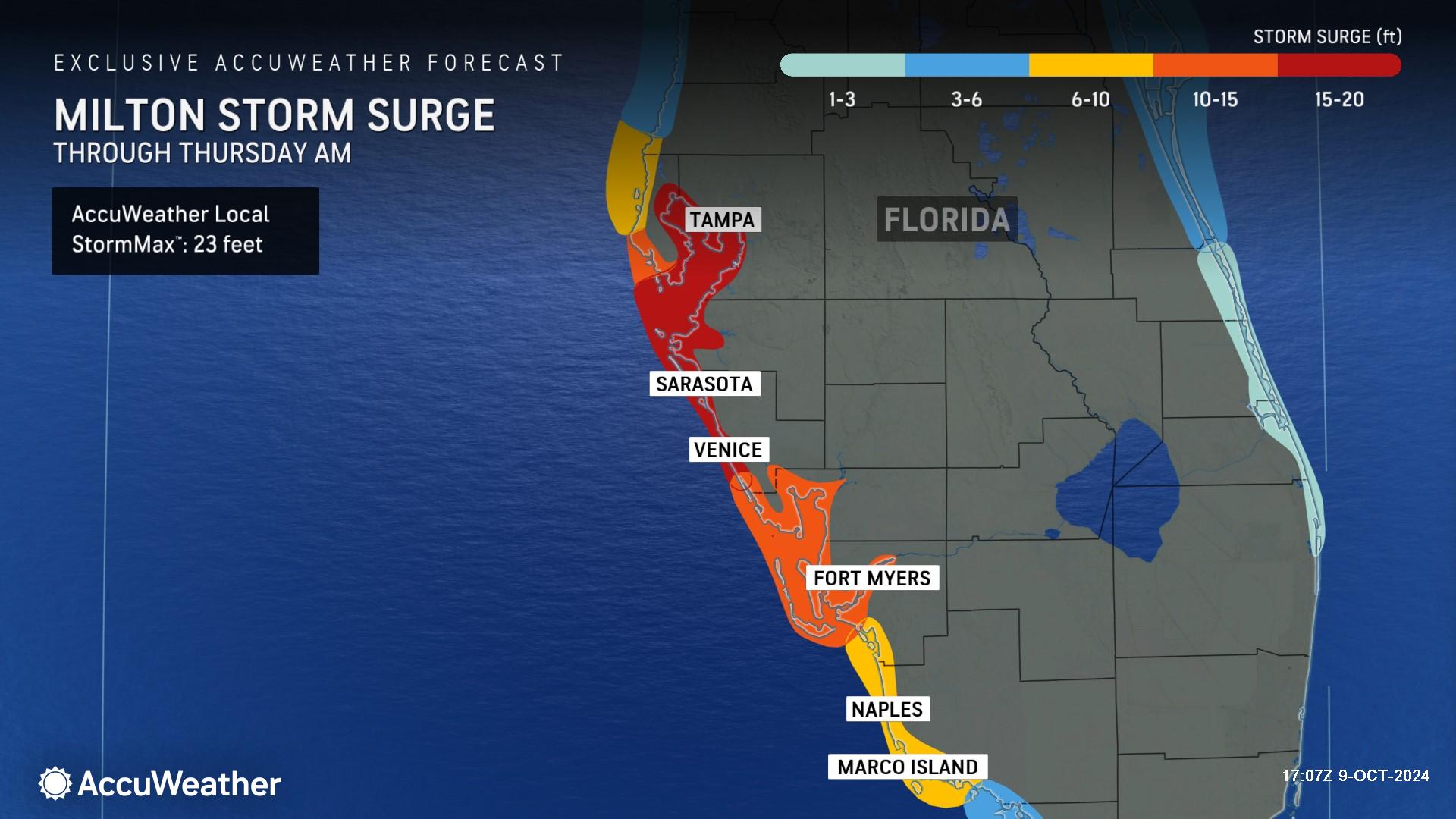
AccuWeather expert meteorologists say 15-20 feet of destructive storm surge may occur near and south of where Milton makes landfall, likely for Sarasota and Venice, with an AccuWeather Local StormMax™ of 23 feet. A deadly surge is still expected in the Tampa area ahead of the storm, but should the track remain just south of the bay, the area would miss the worst-case scenario.
“Another important point related to Milton’s unusual and historic track into the Tampa Bay region is that various parts of Tampa Bay can receive damaging storm surge as the prevailing wind direction shifts as the Milton approaches the coast, makes landfall then moves east of Tampa Bay. Even as the storm moves away from Tampa, strong northwesterly winds behind Milton can produce damaging storm surge on the southeastern part of the Bay,” said Porter. “Milton will result in unusually high water levels in Tampa Bay, and given the historic track of the storm, flooding may occur in areas that some people do not expect with the inundation resulting in flooding in places that have not been seen before by people who have lived in the Tampa area, even if they have lived there for their entire lives. This also increases the danger and damage potential associated with Milton.”
DaSilva said some areas along the gulf coast could face two rounds of storm surge.
“Little wobbles in this storm track can make a massive difference,” DaSilva said. We could essentially see two rounds of storm surge in some places. The first round of surge will come from the south, followed by wraparound wind coming from the northwest as Milton moves inland and across the peninsula of Florida. We could be dealing with ongoing storm surge problems in some areas through Thursday morning.”
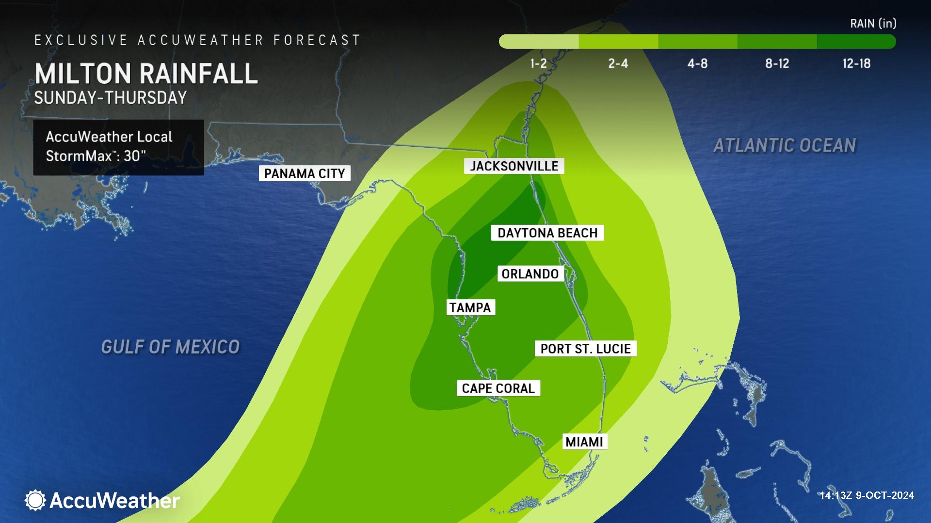
Rainfall totals of 4-8 inches are forecast to extend across much of the Florida Peninsula. Across central and northeastern parts of the Florida Peninsula, rainfall totals can reach 8-12 inches. Along the northern side of Milton’s path, 12-18 inches of rain may fall, with an AccuWeather Local StormMax™ of 30 inches.
“The heaviest rainfall is expected to be on the east, north and northwest sides of this hurricane because Milton will be interacting with a dip in the jet stream. When that happens, we typically see a lot of moisture on that side of the storm,” said DaSilva. “AccuWeather is forecasting a zone of 12 to 18 inches of rain along the populous Interstate 4 corridor. This area will be the bull’s-eye for flooding rainfall, just to the north of Tampa to Orlando and Daytona Beach. We could see widespread inland flooding with impacts that could last for days.”
Porter says river flooding is also a major concern in parts of central and northern Florida.
“Jacksonville could see several feet of storm surge as Milton moves across the state and offshore into the Atlantic. All of that rain and storm surge could create serious river flooding issues, especially along the St. Johns River, which flows north and empties into the Atlantic near Jacksonville,” Porter explained. “We could be dealing with river flooding problems for days or even weeks.”
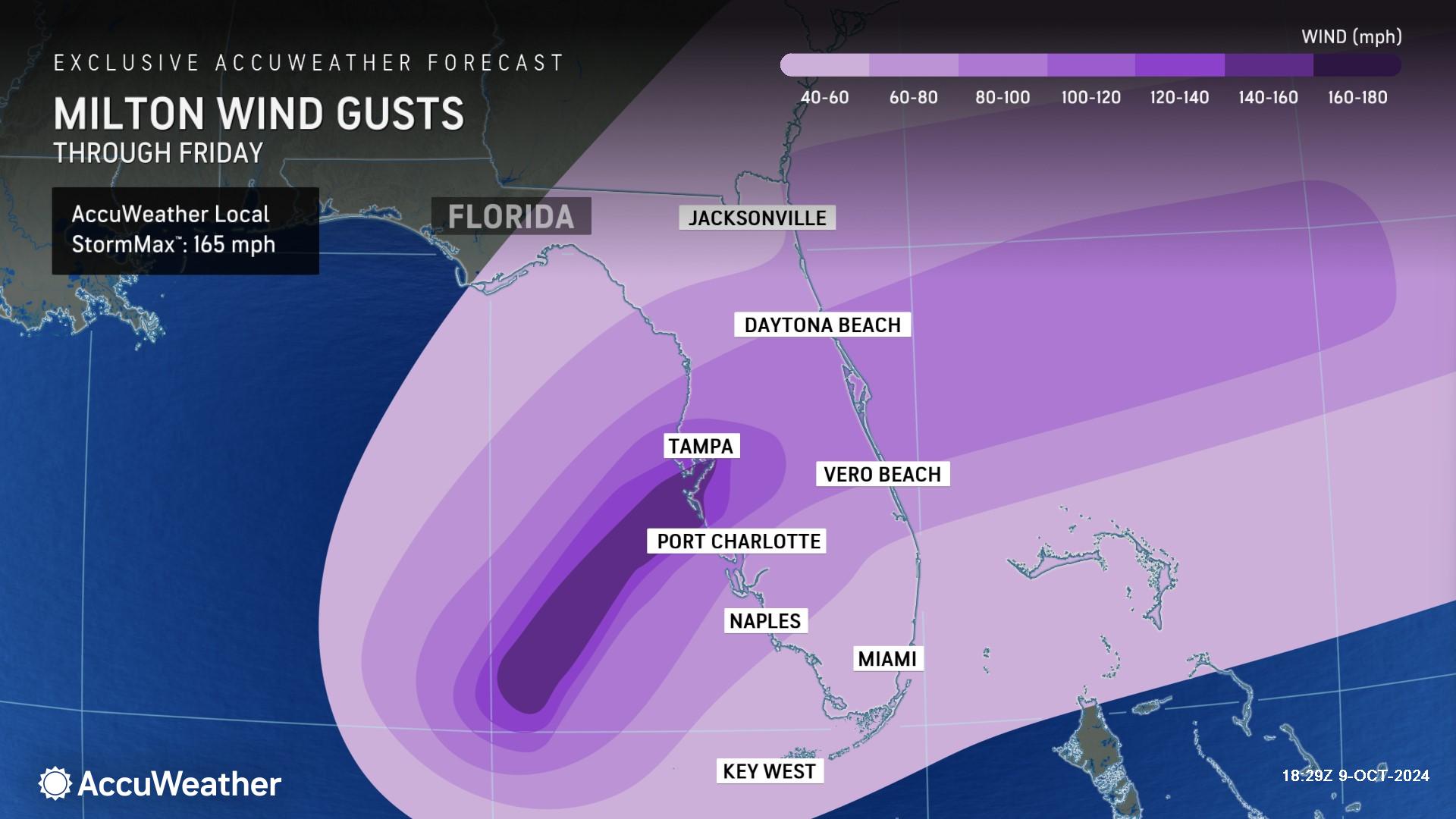
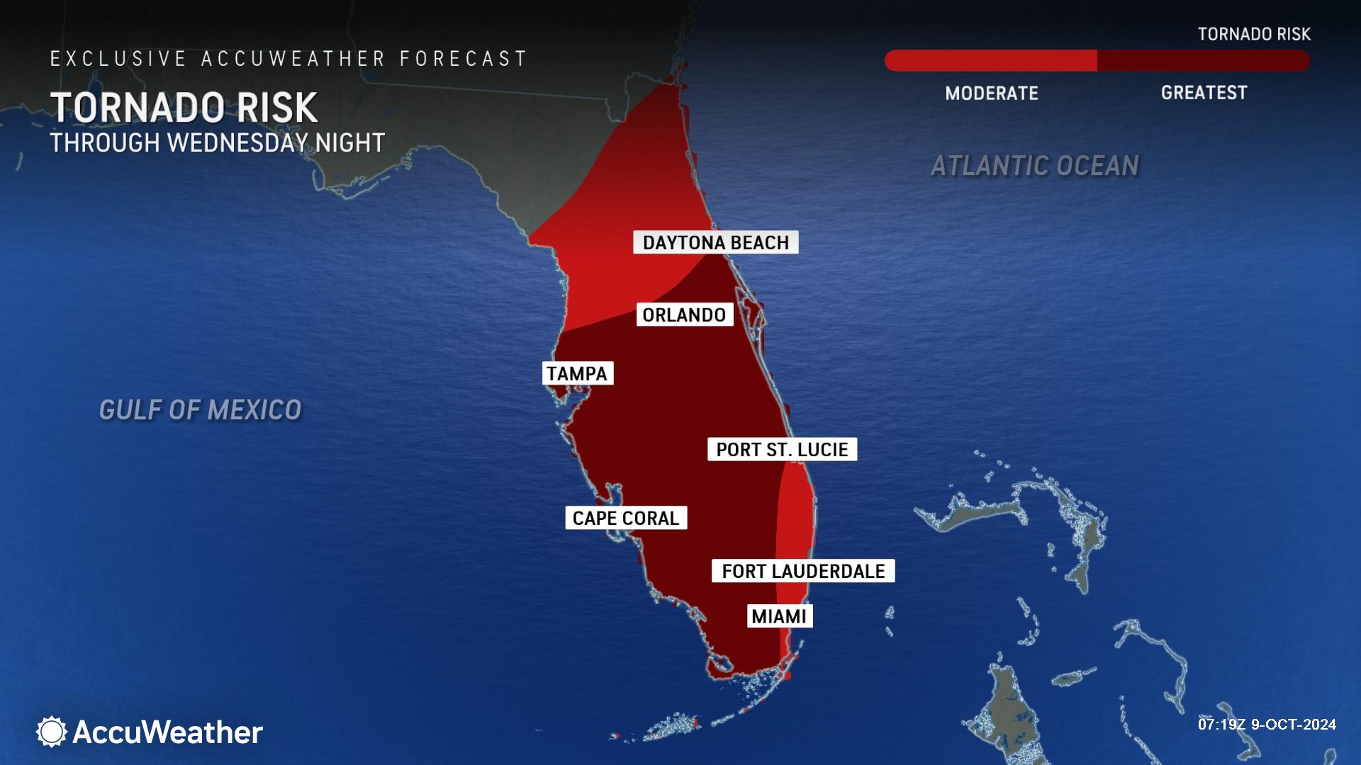
Stronger winds are expected as the storm makes landfall in the Florida Peninsula on Wednesday night. Wind gusts of 60-80 mph can occur across much of the central and southern Florida Peninsula. Near where the center of circulation makes landfall, wind gusts can reach 140-160 mph with an AccuWeather Local StormMax™ of 165 mph. AccuWeather expert meteorologists are also warning people to be prepared for overnight tornado warnings as Milton approaches the coastline and moves across the state.
“We could see more tornadoes spin up, especially to the south and east of Milton as it barrels across Florida,” DaSilva said. “Milton will bring powerful winds across the state. Orlando could see wind gusts close to 90 mph or even 100 mph.”
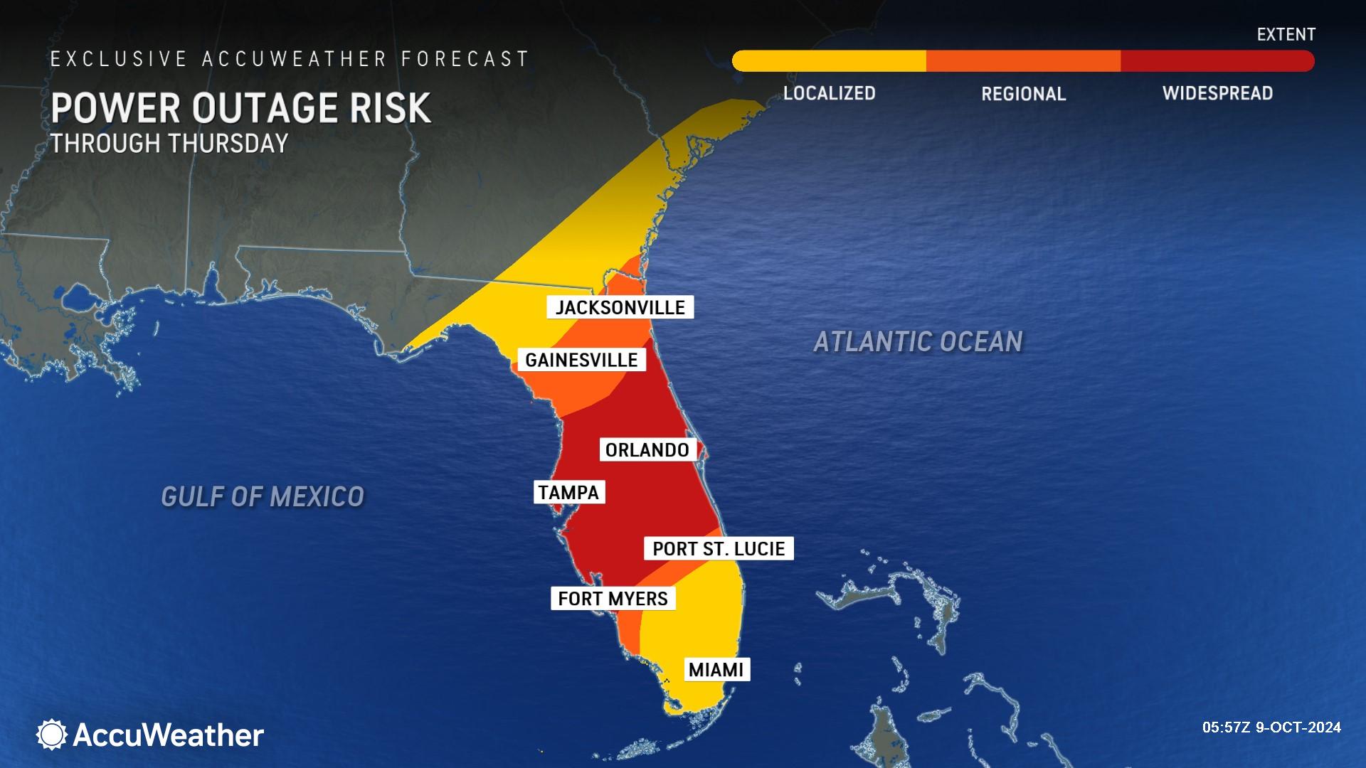
AccuWeather expert meteorologists say families, businesses, emergency officials and government leaders need to be prepared for extended power outages and connectivity issues across much of Florida. This will also have a significant impact on tourism for the state.
“The core of the destructive wind gusts will move right up through the Interstate 4 corridor. These winds could cause significant structural damage and cause widespread power outages that could last for weeks,” said Porter. “Families who are inland in the path of this storm should hunker down and treat it like a tornado warning. Stay in an interior part of your home that is away from windows and exterior doors and away from any large trees that could fall onto your roof.”
AccuWeather Founder and Executive Chairman Dr. Joel Myers says the total damage and economic loss from Hurricane Helene and Hurricane Milton within the span of two weeks could have major ripple effects felt across the nation.
“We had a $200 billion to $250 billion economic loss when you look at all of the immediate damage and long-term impacts from Hurricane Helene. This hurricane may be just as damaging, certainly in that ballpark. We're looking at back-to-back landfalls from two devastating hurricanes; it's very unusual. The total economic loss over the next three to six months could add up to a staggering $400 billion to $500 billion,” Dr. Myers said. “This hurricane certainly will impact some of the crops that are grown in Florida, including oranges, tomatoes and grapefruits. We’ll likely see upward pressure on prices over the next several months.”
AccuWeather expert meteorologists say a tropical cyclone originating in the Bay of Campeche and tracking east into the Gulf Coast of Florida late in the hurricane season is very rare. The Tampa Bay area has not had a hurricane making landfall in the area in over a century.
Milton recorded the fifth lowest central pressure in the history of the Atlantic basin at 897 mb on Monday evening.
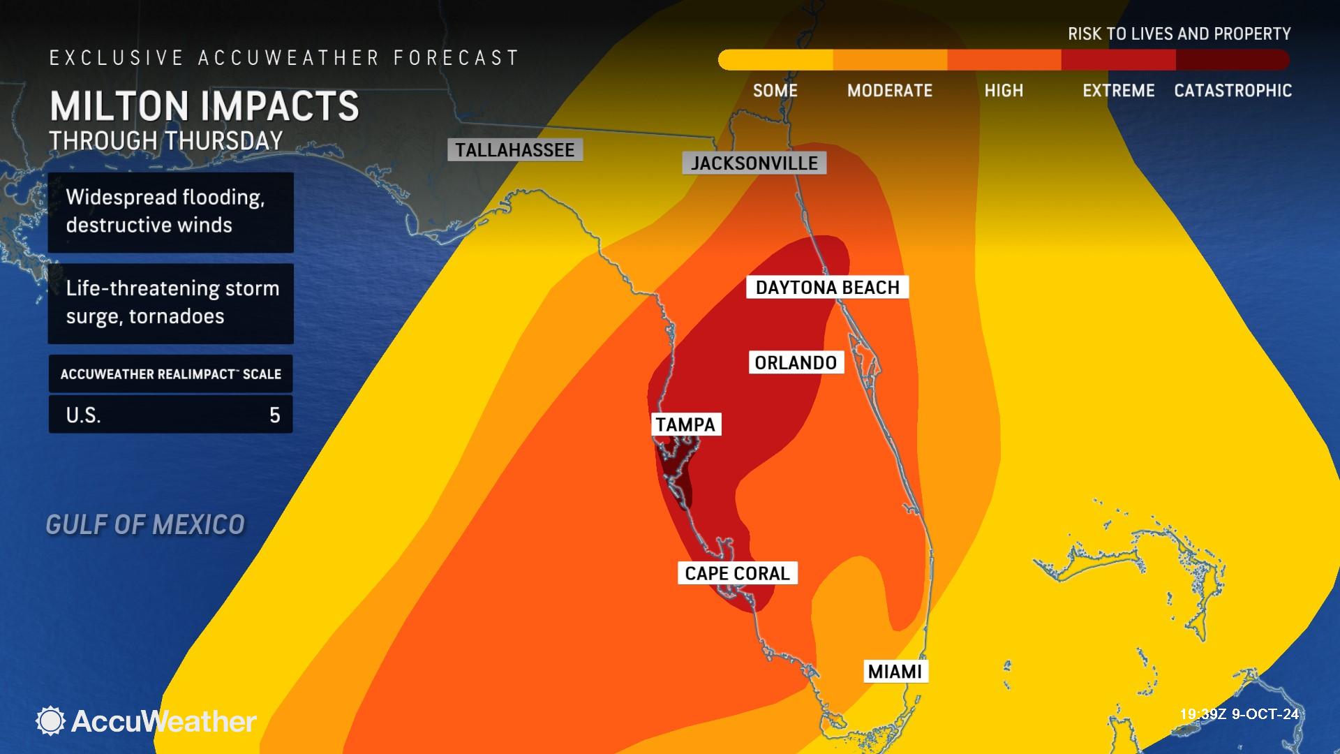
On Tuesday afternoon, AccuWeather expert meteorologists increased Hurricane Milton to a 5 on the AccuWeather RealImpact™ Scale for Hurricanes in the United States.
In contrast to the Saffir-Simpson Hurricane Wind Scale, which classifies storms by wind speed only, the AccuWeather RealImpact™ Scale is based on a broad range of important factors. In order to better communicate a more comprehensive representation of the potential impact of a storm to lives and livelihoods, the scale covers not only wind speed, but also flooding rain, storm surge and economic damage and loss. Some of these hazards such as inland flooding and storm surge in many storms result in more deaths and economic loss than wind.
A 5 on the AccuWeather RealImpact™ Scale for Hurricanes warns of widespread catastrophic flooding in major population centers. Flooding may last days to weeks. structural damage to buildings, power outages and trees down, as well as catastrophic inundation in populated areas will be widespread. Coastlines altered by the hurricane may take years or longer to recover.
The last time AccuWeather expert meteorologists issued a 5 on the AccuWeather RealImpact™ Scale for hurricanes was ahead of Hurricane Ian’s catastrophic landfall in the Fort Myers Beach area of Florida in 2022.
AccuWeather Forecast Graphics

Additional AccuWeather Resources:
Hurricane Tracking & Storm Radar
Rapidly Intensifying Hurricanes Near Coastline Pose Major Threat To US This Season


