



AccuWeather meteorologists are available 24/7 to provide further insights and updates on evolving weather conditions. Please contact pr@accuweather.com during regular business hours, or support@accuweather.com or call AccuWeather’s Media Hotline at (814)-235-8710 at any time to arrange interviews with AccuWeather experts or to request the most updated graphics for print or broadcast.
High Risk of Tropical Development in the Caribbean
Nov. 11, 2024

> The next tropical storm in the Atlantic basin could form as early as Thursday
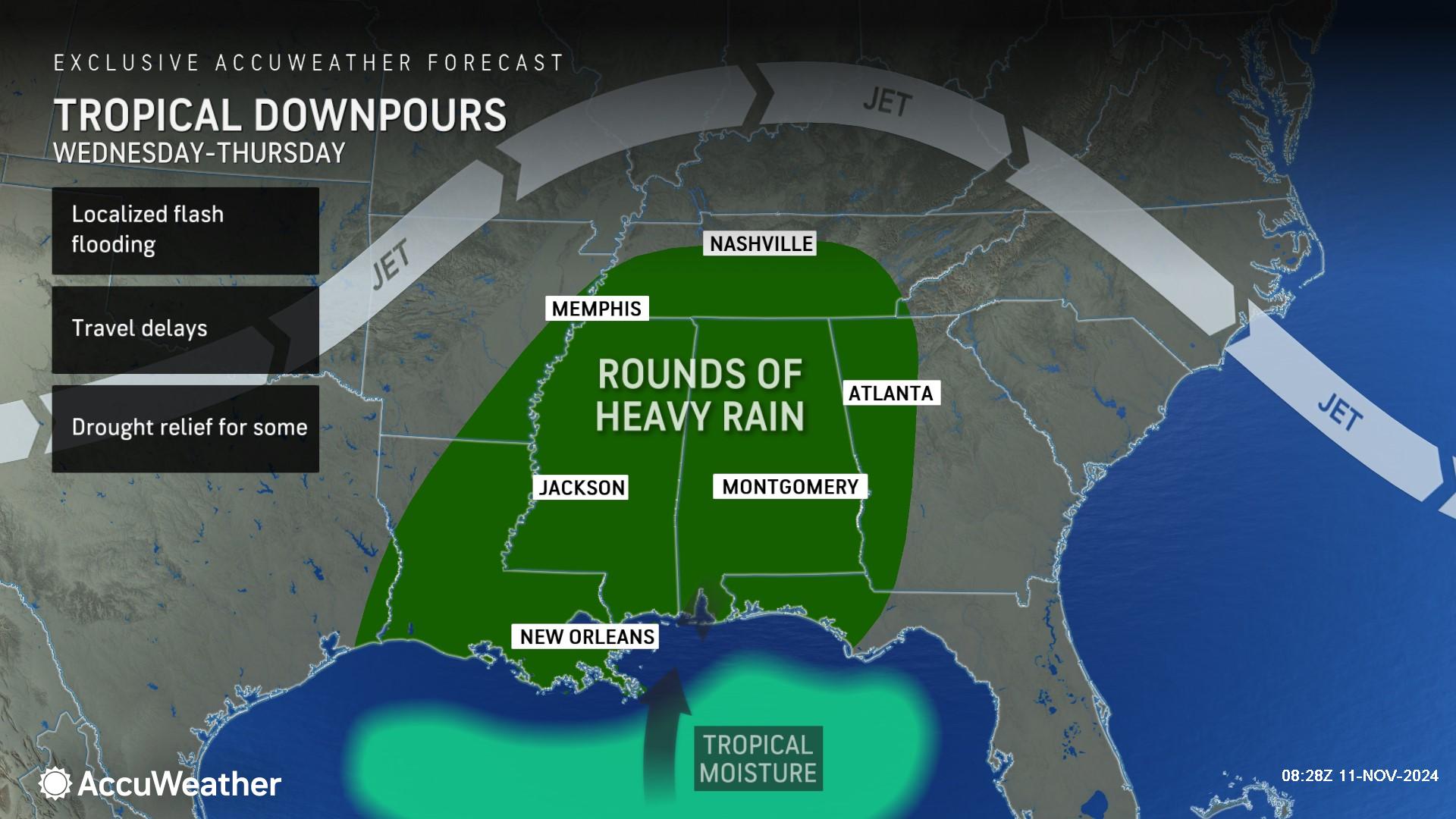
> A surge of tropical moisture from the ghost of Rafael could trigger heavy rainfall and localized flash flooding along parts of the Gulf coast Wednesday and Thursday
> The next name on the list of tropical storms for the 2024 Atlantic hurricane season is Sara
AccuWeather Global Weather Center – Nov. 11, 2024
AccuWeather hurricane experts are closely monitoring clusters of showers and thunderstorms near Hispaniola and Puerto Rico that could develop into a late-season tropical storm.
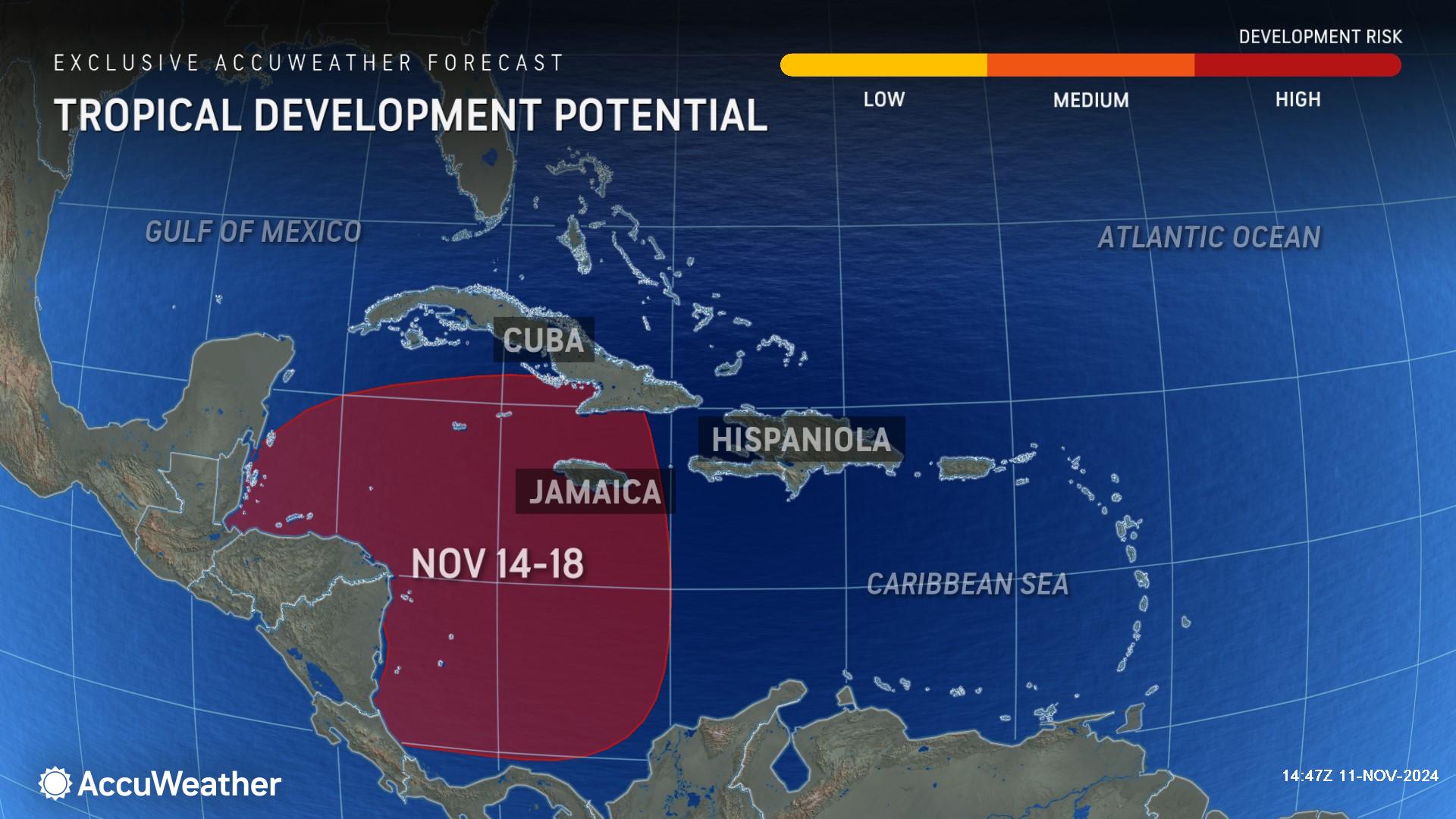
“Get ready for Sara. We expect the next tropical storm to develop in the Caribbean this week,” said AccuWeather Chief On-Air Meteorologist Bernie Rayno. “The development process is already underway. There are showers and thunderstorms around Hispaniola that will move west. The storms will get a boost on Wednesday when wind shear starts to fade away. A front will provide more upward motion by midweek, helping these storms organize.”
On Monday morning, AccuWeather hurricane experts issued a high risk for potential tropical development in the western Caribbean between Nov. 14-18.
AccuWeather hurricane experts say there will be a zone of wind shear north of the Caribbean that will initially tend to prevent the northward movement of any brewing storm in the Caribbean. However, the natural blocking mechanism could dissolve during the third week of November and allow any tropical storm to move northward.
Families and businesses from Central America to southeastern Mexico, Cuba, Jamaica, Hispaniola and Puerto Rico should monitor the Caribbean for budding tropical activity and related torrential downpours and gusty thunderstorms beginning later next week.
“Don’t let your guard down just because the calendar says we’re heading into mid-November. Conditions and water temperatures in the tropics are still primed for tropical storms to form in the final weeks of hurricane season,” said AccuWeather Lead Hurricane Expert Alex DaSilva. “History shows that Florida faces a higher risk of tropical impacts than any other state during the month of November.”
AccuWeather hurricane experts warned in late October of a final surge of tropical storms expected in the month of November, forecasting one to three named storms to develop in the Atlantic basin during the final month of the hurricane season. Subtropical Storm Patty and Hurricane Rafael both formed during the first week of November.
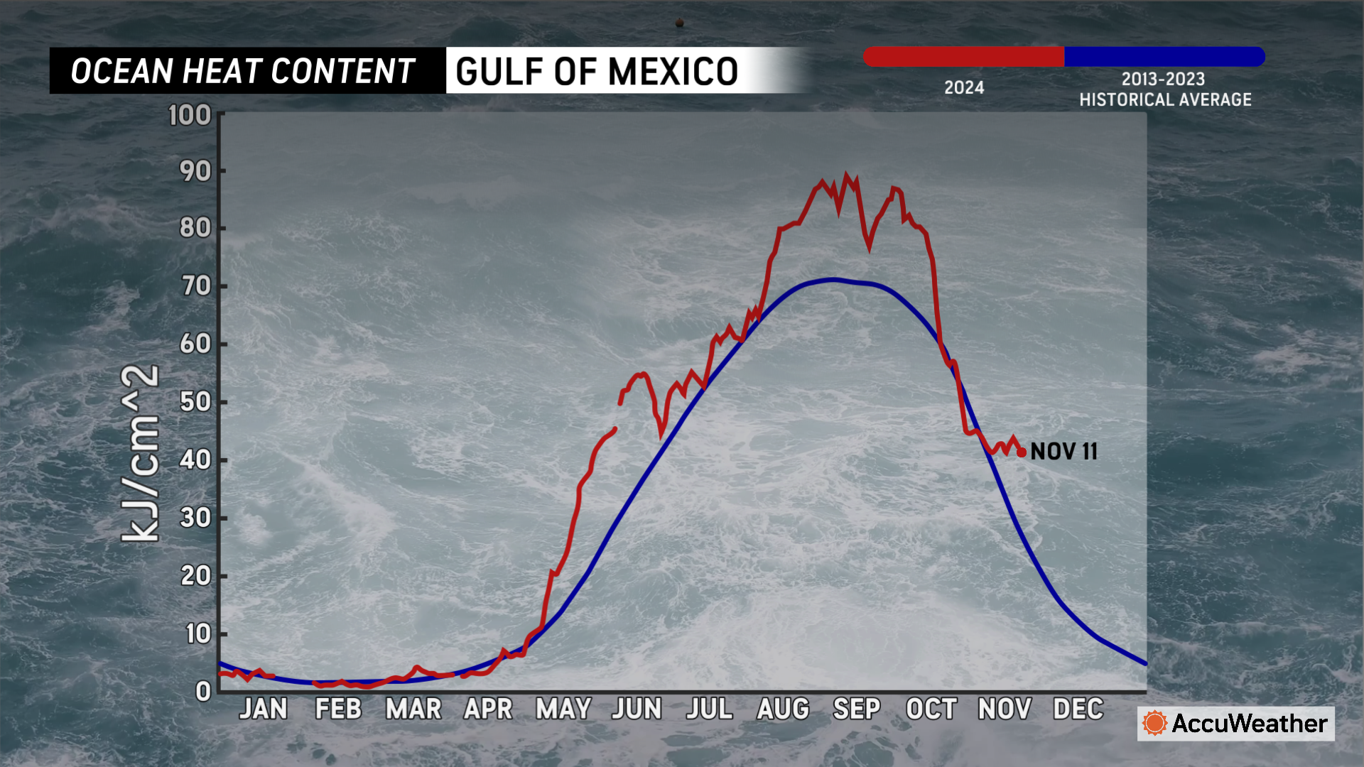
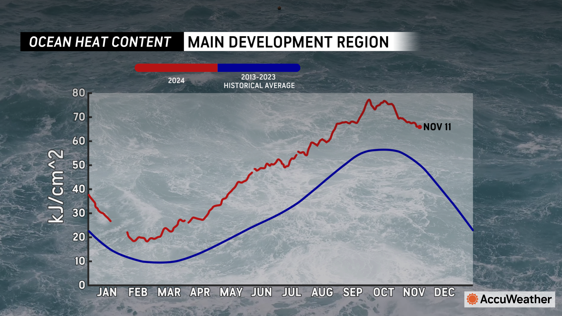
“We still have exceptionally warm waters heading into mid-November. Ocean heat content, or the depth that warm waters reach beneath the surface, is at record levels for this time of year in the Gulf of Mexico,” said DaSilva. “Ocean heat content is near record levels for mid-November in the Caribbean. These warm waters will provide extra fuel for any storms that can develop in the next few weeks.”
Flooding risk along the Gulf Coast in the wake of Rafael
AccuWeather hurricane experts say Rafael lost much of its circulation over the central Gulf of Mexico Sunday night and has been reduced to a shredded zone of downpours and thunderstorms.
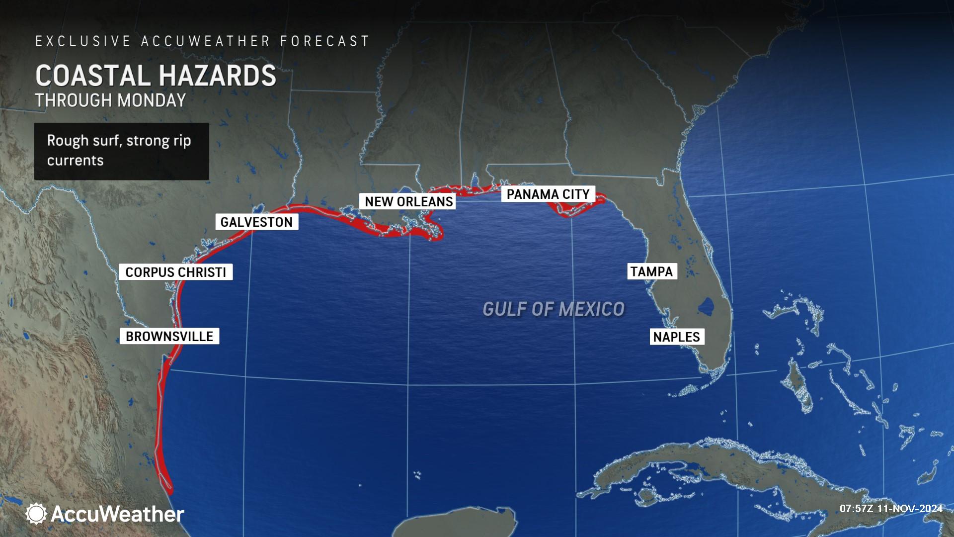
Rough surf and rip currents are possible along the Gulf coast from South Texas to the Florida Panhandle through Monday night.
Moisture that was sheared off from Rafael enhanced rainfall along the Gulf coast over the weekend and triggered localized flash flooding.
What is left of Rafael's center is forecast to wander or loop around over the western and central Gulf over the next couple of days. Increasing wind shear will continue to shred what is left of Rafael's circulation and much of its moisture.
AccuWeather expert meteorologists say a surge of tropical moisture could bring rounds of heavy rain to parts of Louisiana, Arkansas, Mississippi, Alabama, Florida, Georgia and Tennessee by Wednesday into Thursday.
"We believe that some of Rafael's remaining moisture will be drawn northward into the central Gulf Coast region around the middle of the week as yet another non-tropical feature -- a cold front -- moves from west to east over the lower Mississippi Valley," said AccuWeather Meteorologist Grady Gilman. "The new cool front will also be more progressive than the one that unloaded as much as 8 inches of rain Saturday. Although downpours can produce minor flooding, persistent downpours aren’t expected, and widespread flooding is not anticipated.”
AccuWeather Forecast Graphics
Additional AccuWeather Resources:
Former Rafael to cause trouble ahead of new tropical activity in Caribbean
October heat 2nd worst on record in US, more than 5,000 records broken


