


AccuWeather meteorologists are available 24/7 to provide further insights and updates on evolving weather conditions. Please contact pr@accuweather.com during regular business hours, or support@accuweather.com or call AccuWeather’s Media Hotline at (814)-235-8710 at any time to arrange interviews with AccuWeather experts or to request the most updated graphics for print or broadcast.
High Risk of Destructive Storms in Upper Midwest, Severe Weather Threat Shifts East this Week
June 24, 2024

> Damaging wind gusts, flash flooding, hail, and isolated tornadoes are possible
late Monday night from the eastern Dakotas and Minnesota to Wisconsin,
Illinois, and Michigan

> Moderate to major river flooding issues are expected due to repeated rounds
of thunderstorms

> Severe thunderstorm risk will move to parts of the Northeast and New England
by Wednesday
AccuWeather Global Weather Center – June 24, 2024
AccuWeather expert meteorologists have issued a ‘high risk’ of severe thunderstorms in parts of southeastern Minnesota, southern Wisconsin, and northeastern Iowa for late Monday night.
Severe thunderstorms near Minneapolis, Rochester, and Madison could produce widespread damaging wind gusts of 65-75 mph, flash flooding, large hail, and isolated tornadoes.
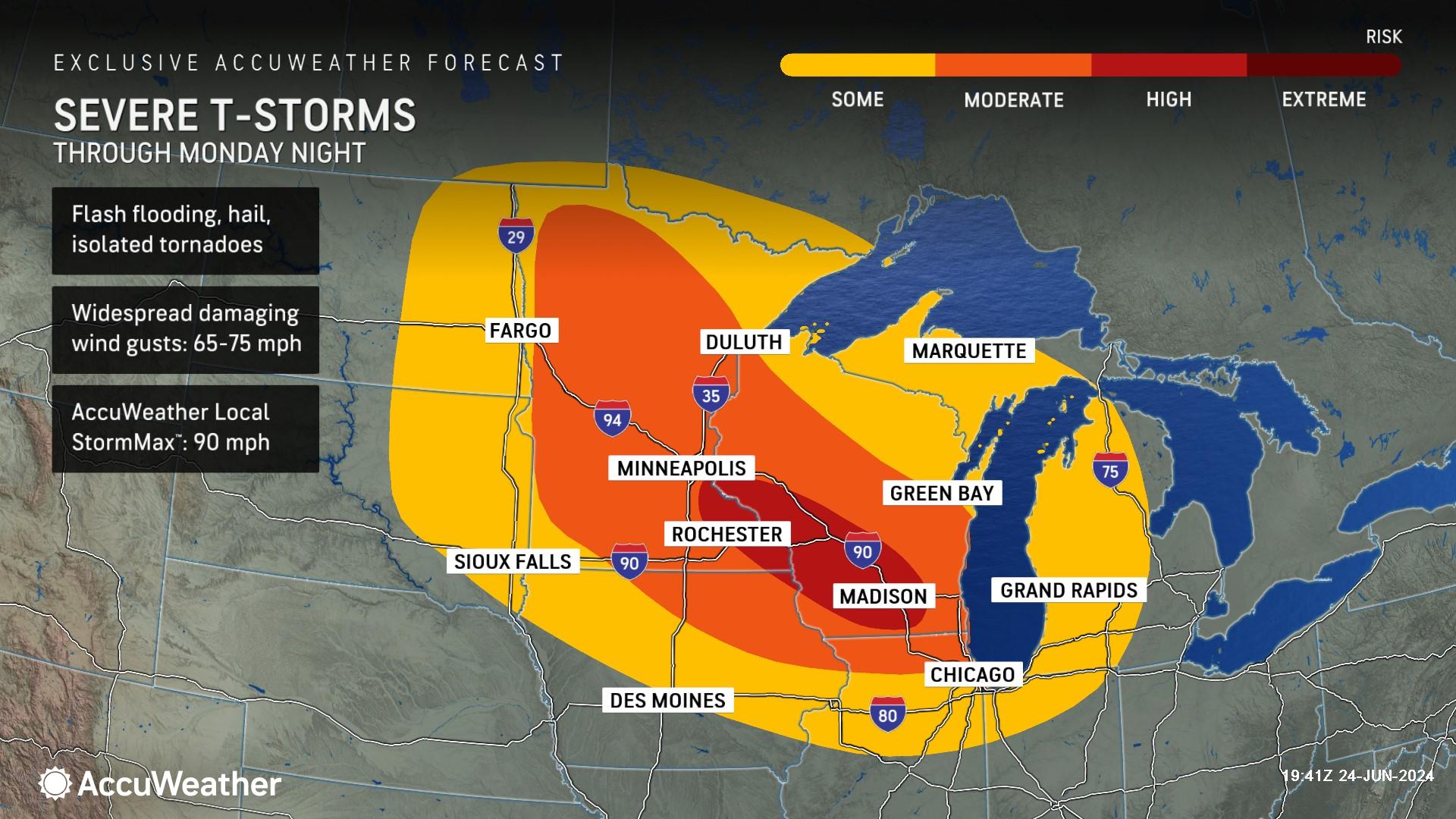
A derecho may even evolve from this severe weather threat. AccuWeather expert meteorologists say a derecho is a thunderstorm complex with a width of at least 60 miles that travels along a path of at least 400 miles. The thunderstorm complex must have wind gusts of at least 58 mph over this path to be categorized as derecho.
The thunderstorm cluster may race toward northern Illinois, including parts of the Chicago metropolitan area, and also into parts of Michigan by Tuesday morning.
AccuWeather Chief On-Air Meteorologist Bernie Rayno says widespread damaging wind gusts of 65-75 mph are the greatest threat. The AccuWeather Local StormMax™ is 90 mph.
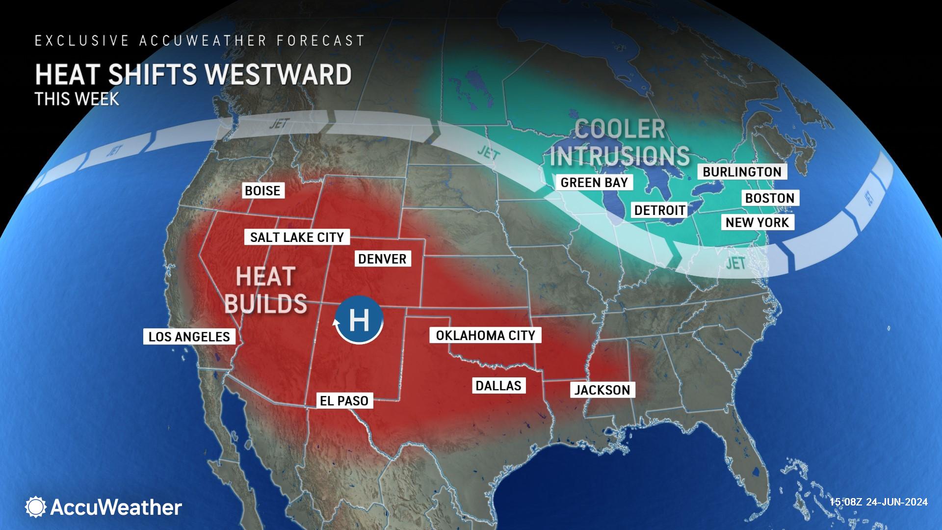
“Thunderstorms are going to be fueled by heat and humidity. We’re not expecting the severe weather where we have triple-digit heat, like Omaha and Kansas City. It will be farther north,” explained Rayno. “We have an upper-level low-pressure area moving through the Canadian prairies. That’s going to bring in a surge of heat and humidity from the southern Plains and ram it northward. At the surface, we’re expecting a surge of hot air coming in from the southwest and cooler air aloft. That combination, along with enhanced upward motion, will cause thunderstorms to explode.”
Rayno says severe thunderstorms could reach parts of the Chicago metro early Tuesday morning.
AccuWeather Chief Meteorologist Jon Porter said families need to be prepared for the severe weather threat late tonight and overnight, which could cause power outages. AccuWeather first forecast the elevated threat of severe thunderstorms or a derecho in this region on June 7.
“The low-level jet typically ramps up at night. Those are the winds roughly 5,000 feet above the ground. That wind is transporting some of that heat and humidity and drawing that northward. That will help sustain and intensify that line of storms late tonight,” said Porter. “Be ready to move to a safe shelter. When thunderstorms pack wind gusts above 65 or 70 mph, treat that like a tornado threat. Be able to move to an interior room in the lowest level of your home and make sure you have multiple ways of getting warnings quickly at night to wake you up, so you can take necessary action, since the greatest risk will occur in the overnight hours in many places.”
Porter says some of the same areas at risk for severe thunderstorms tonight have been dealing with considerable flooding in recent days, which can amplify the impact of the severe thunderstorms by creating even more complications for storm response and recovery, such as power restoration.
Repeat Storms Causing Rivers to Flood
AccuWeather expert meteorologists say rounds of thunderstorms and heavy rainfall since mid-June has led to river flooding in several states across the Midwest and northern Plains.
River gauges are reporting water levels reaching major flood stage in South Dakota, Iowa, and Minnesota.
AccuWeather Senior Meteorologist Alex Sosnowski says the stormy pattern is expected to continue through the final days of June.
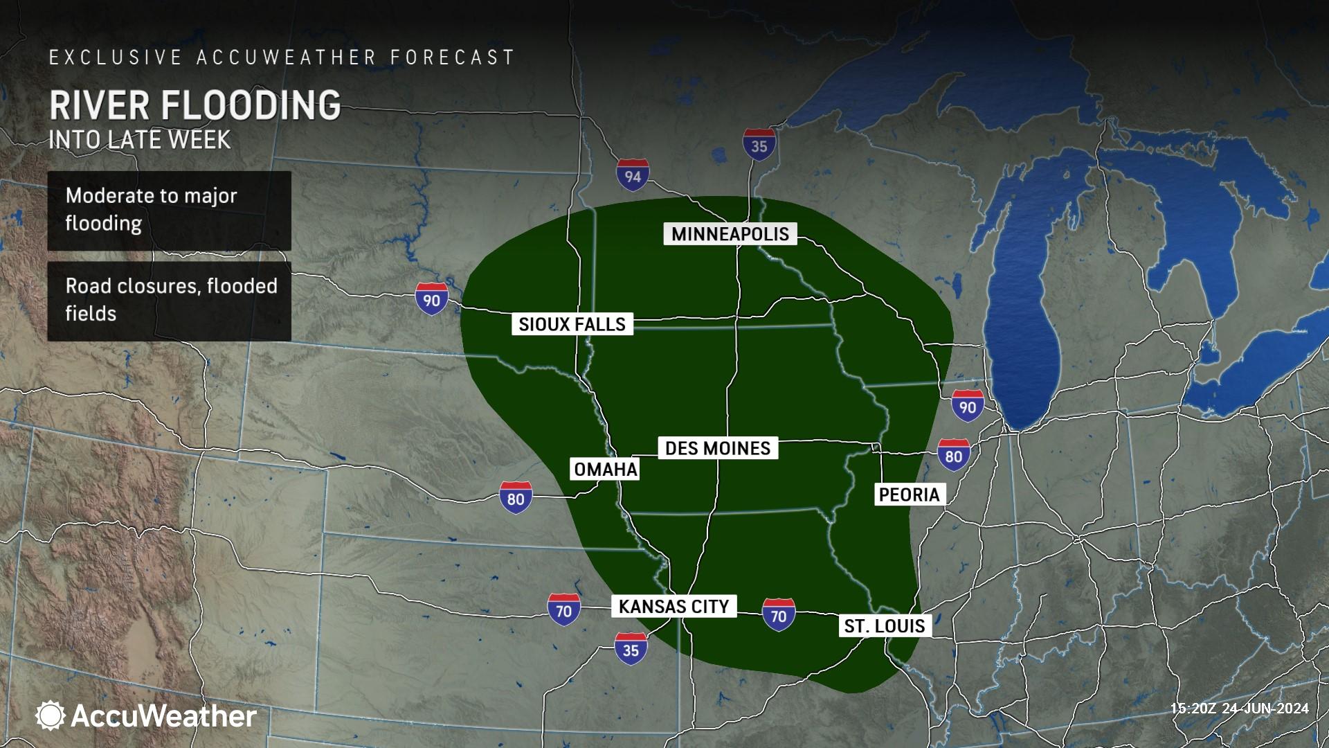
"So much rain has fallen in a zone from southwestern Minnesota to northeastern Nebraska, including northwestern Iowa and southeastern South Dakota, that multiple rivers are on the rampage," said Sosnowski. "Several major rivers in the region, including the Big Sioux and West Fork of the Des Moines rivers, will be in major to record flood stage through early week."
Parts of this region have received a month's worth of rain in two to three days. Sioux Falls, South Dakota, received 6.33 inches of rain in 72 hours from Thursday to Saturday, with 10.8 inches of rain so far in June. This puts June 2024 as the city's second-wettest month on record. The wettest June was in 2014, with 13.70 inches. The historical average rainfall for all of June in the southeastern South Dakota city is 4.23 inches.
Severe Thunderstorm Threat Shifts East
A cold front progressing southeastward on Tuesday will bring the risk of severe thunderstorms to much of the Great Lakes region and the central Plains.
AccuWeather expert meteorologists say there is a moderate risk of severe thunderstorms along the Interstate 35 corridor between Des Moines, Iowa, and Kansas City, Missouri.
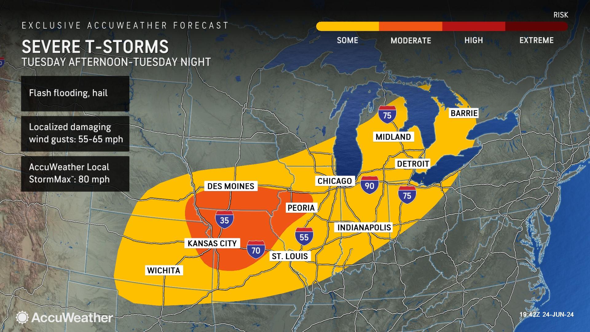
The severe weather threat will advance farther east on Wednesday, with the threat of flash flooding, hail, and damaging wind gusts across much of the Northeast and parts of the mid-Atlantic.
There is a moderate risk of severe thunderstorms in parts of Pennsylvania, Maryland, New York, and New Jersey.
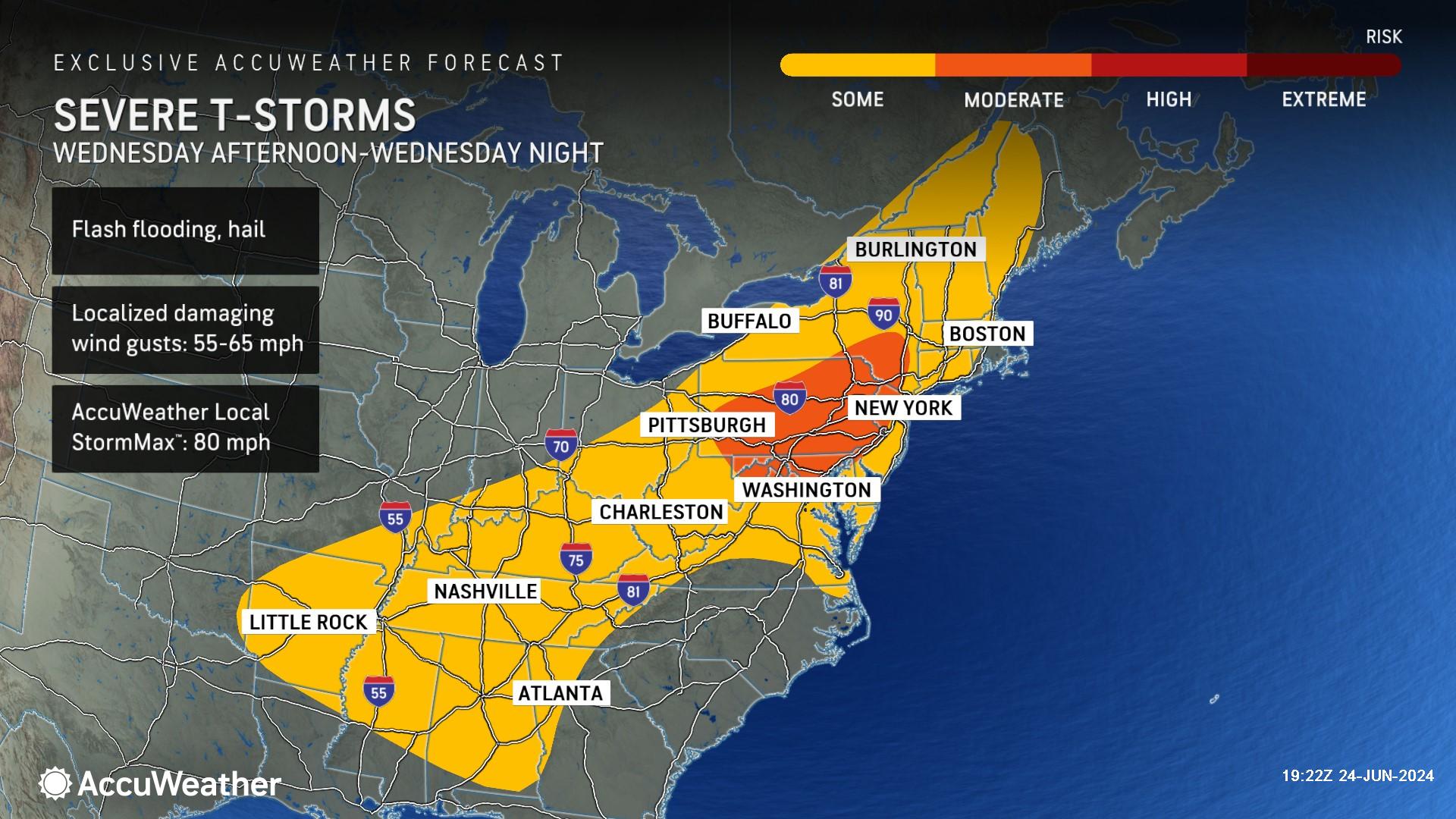
AccuWeather expert meteorologists warn that the front's forward progression may slow just enough to create a heightened risk of flash flooding from repeating heavy thunderstorms later Wednesday, from parts of the upper Ohio Valley to the central Appalachians and New England.
Additional AccuWeather Resources:


