AccuWeather meteorologists are available 24/7 to provide further insights and updates on evolving weather conditions. Please contact pr@accuweather.com during regular business hours, or support@accuweather.com or call AccuWeather’s Media Hotline at (814)-235-8710 at any time to arrange interviews with AccuWeather experts or to request the most updated graphics for print or broadcast.
Rafael is forecast to hit Cuba as a hurricane before bringing tropical storm impacts to US Gulf Coast
Nov. 5, 2024
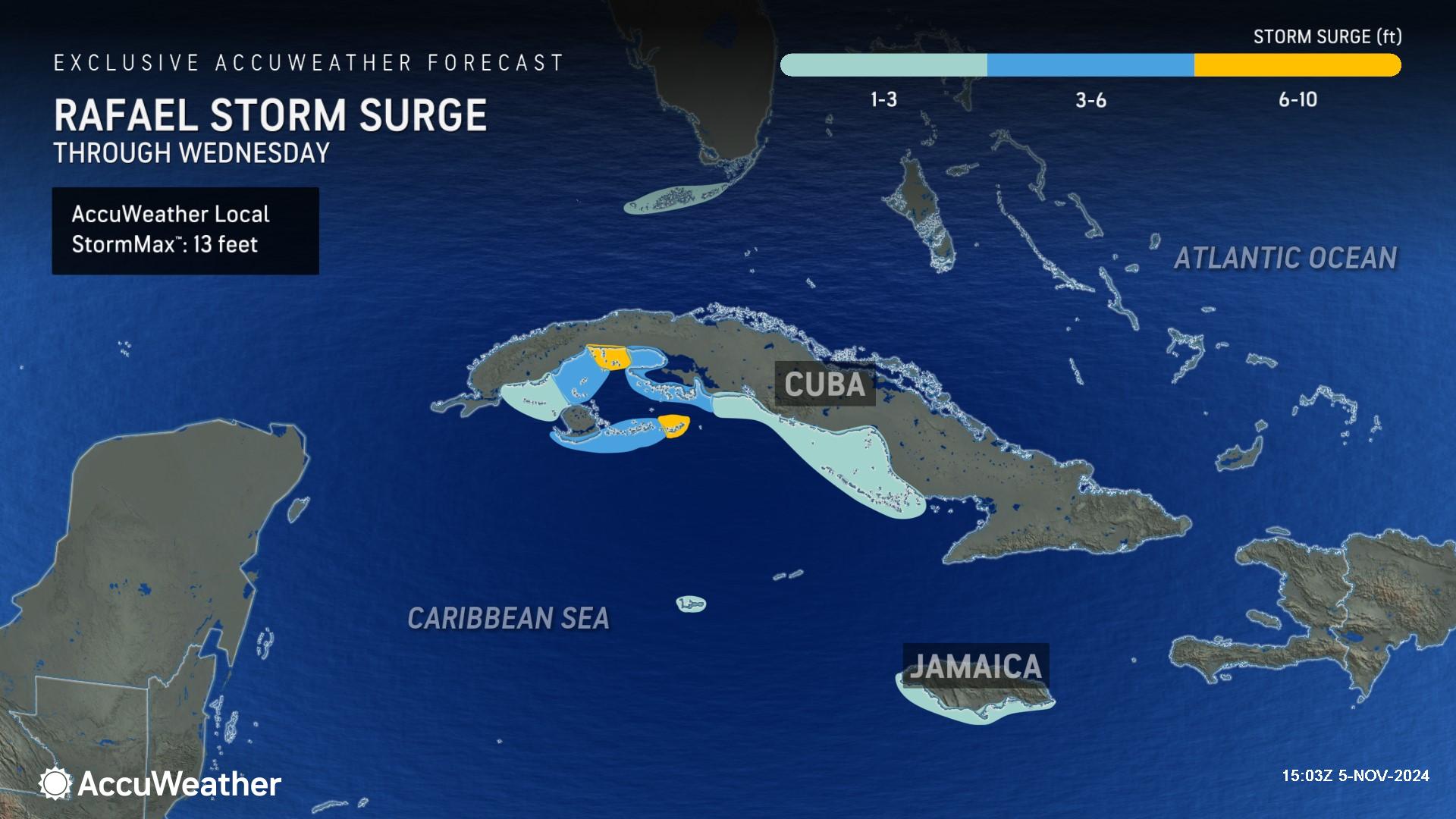
> AccuWeather Local StormMax™ of 14 inches of rainfall, 130-mph wind gusts, and 13 feet of storm surge are possible in Cuba
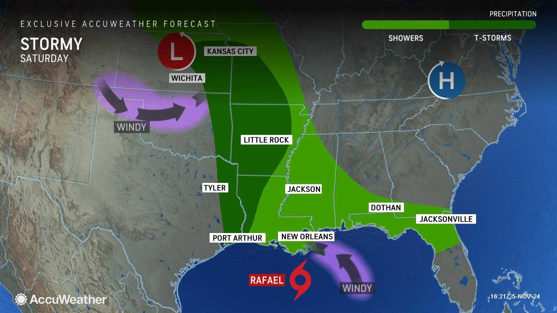
> Rare storm track for November could bring rain and wind impacts to the US Gulf Coast this weekend
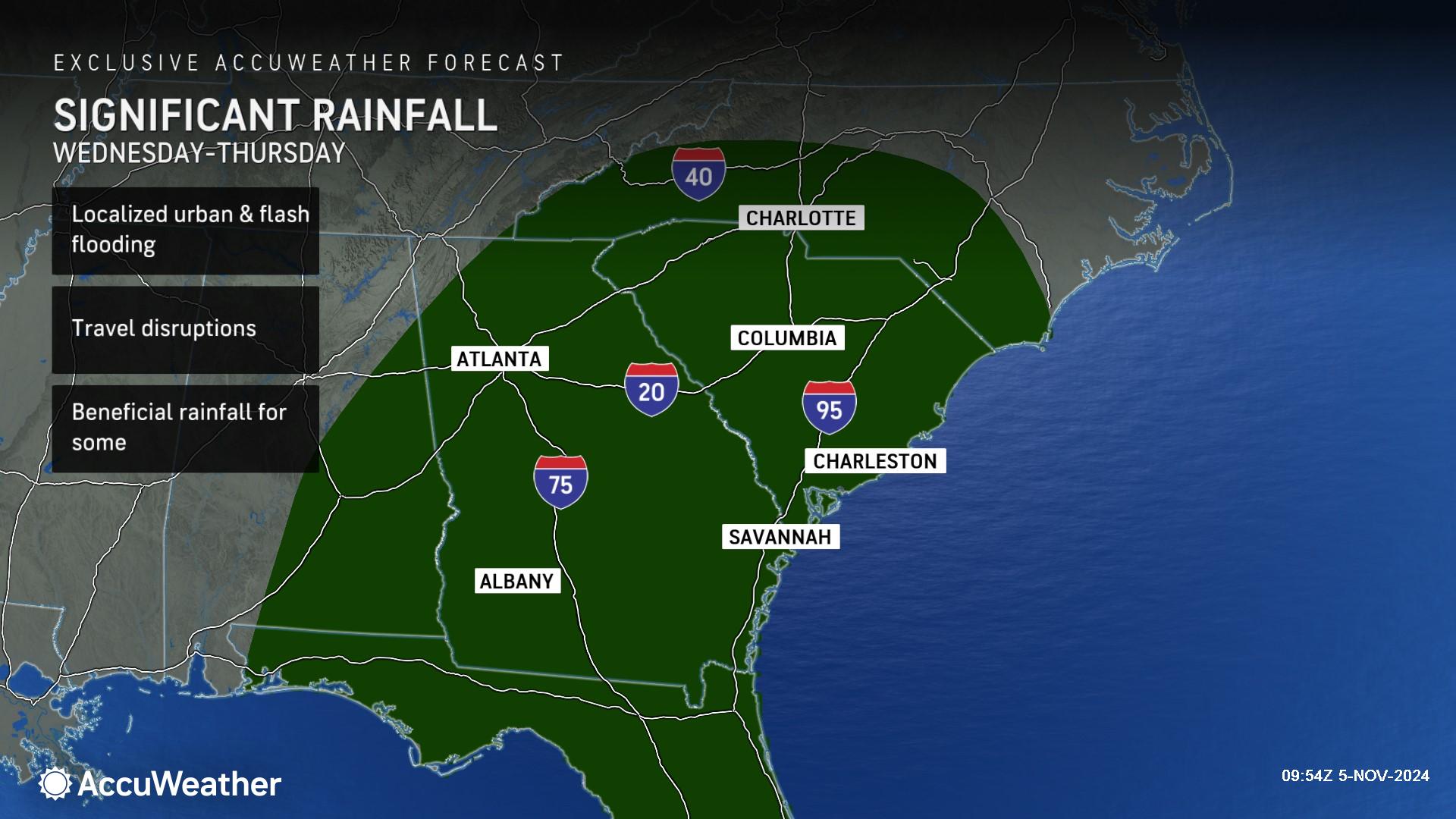
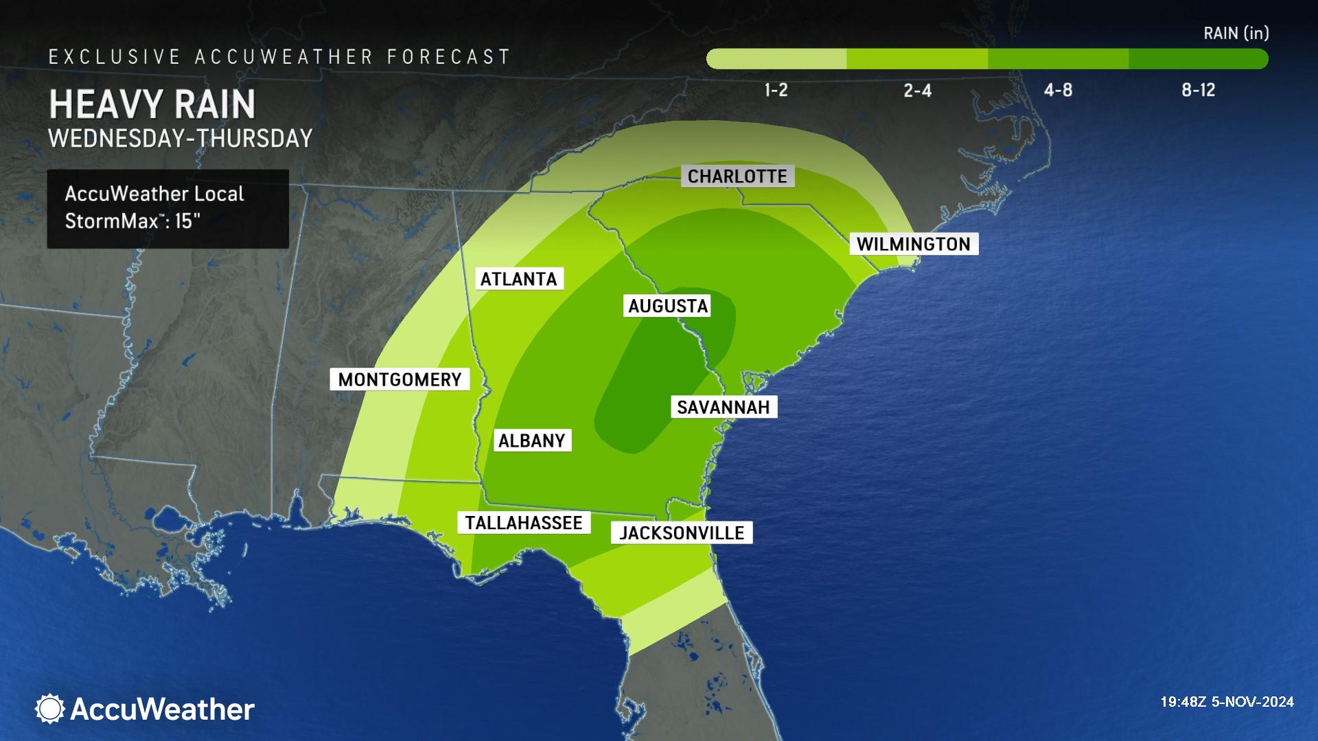
> A non-tropical storm could bring heavy rainfall and flooding impacts to parts of the Southeast and inland areas impacted by Helene Wednesday and Thursday
AccuWeather Global Weather Center – Nov. 5, 2024
AccuWeather hurricane experts say families and businesses along the Gulf coast from Louisiana to Florida should prepare for tropical storm impacts from Rafael later this week, after the storm makes landfall in Cuba Wednesday.
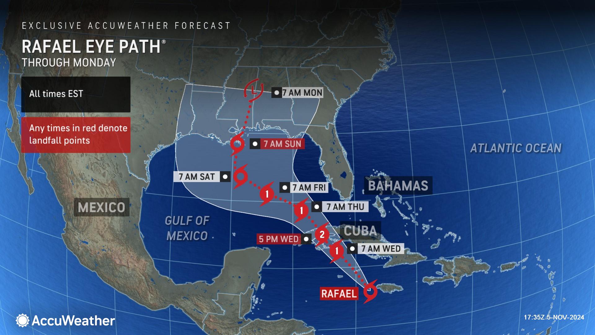
“Rafael is expected to intensify into a hurricane quickly before making landfall in Cuba. Everyone along the Gulf coast should pay close attention to this storm,” said AccuWeather Chief Meteorologist Jon Porter. “The center of the storm could eventually make landfall between the Florida Peninsula and the upper Texas coast as we look ahead to the weekend. Every forecast has different levels of confidence. The exact forecast for Rafael reaching the United States has a lower confidence than typical because of two key weather factors. Steering winds from an area of high pressure off the East coast and a dip in the jet stream over Texas will determine where Rafael eventually makes landfall. Small differences between these two factors could have a big impact on the track of this storm.”
Impacts in the Caribbean
AccuWeather hurricane experts say Rafael will track near Jamaica and the Cayman Islands through Tuesday night, bringing damaging winds, flooding rain, and a few feet of storm surge. Conducive atmospheric conditions should allow for further intensification with the storm becoming a Category 2 hurricane before making landfall in western Cuba, with maximum sustained winds of 96-110 mph on the Saffir-Simpson Hurricane Wind Scale.
"Steering winds will guide the tropical storm on a northwesterly track that takes it near Jamaica and the Cayman Islands on Tuesday and then across Cuba at midweek," said AccuWeather Chief On-Air Meteorologist Bernie Rayno. "In this zone, waters are sufficiently warm, and disruptive wind shear will be low."
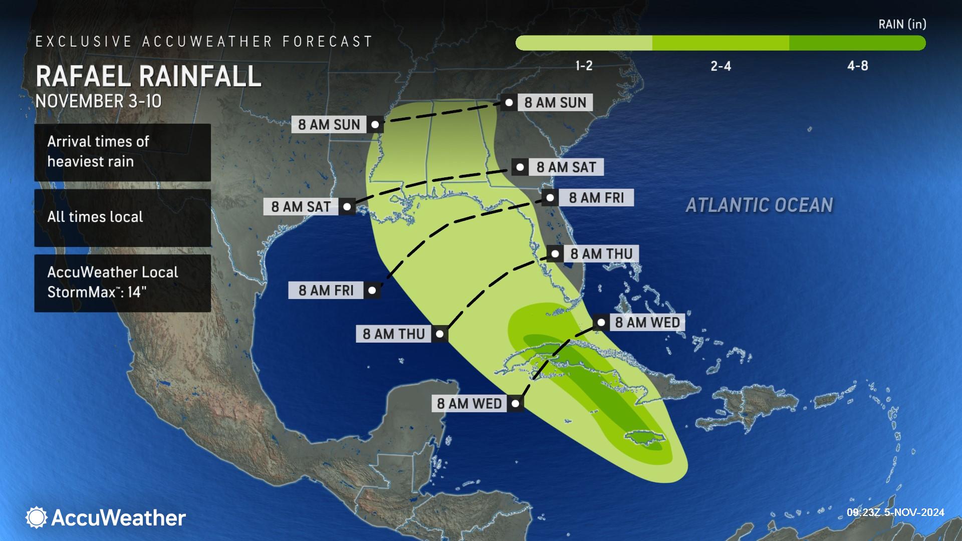
Rafael will bring heavy rain through the western Caribbean, from Jamaica through western Cuba, into the middle part of the week. Rain over central and western Cuba will total 1-2 inches, while heavier amounts of 4-8 inches can fall close to the track of the storm over western Cuba and central Jamaica. Some of the mountains can receive higher amounts, with an AccuWeather Local StormMax™ of 14 inches. This rain can lead to flash flooding, landslides and difficult travel in parts of Jamaica and Cuba.
As Rafael moves into the Gulf of Mexico, rainfall of 1-2 inches can occur from western Florida north through the central Gulf Coast through the end of the week, with 2-4 inches of rainfall possible across the Florida Keys.
“People in the Caribbean islands and the southern Florida Keys need to prepare for impacts,” warned Porter. “Rafael is showing clear signs of an organizing and intensifying storm. We cannot rule out the possibility that Rafael could intensify into a major hurricane before reaching Cuba. That would be Category 3 with maximum sustained winds of 111-129 mph on the Saffir-Simpson Hurricane Wind Scale.”
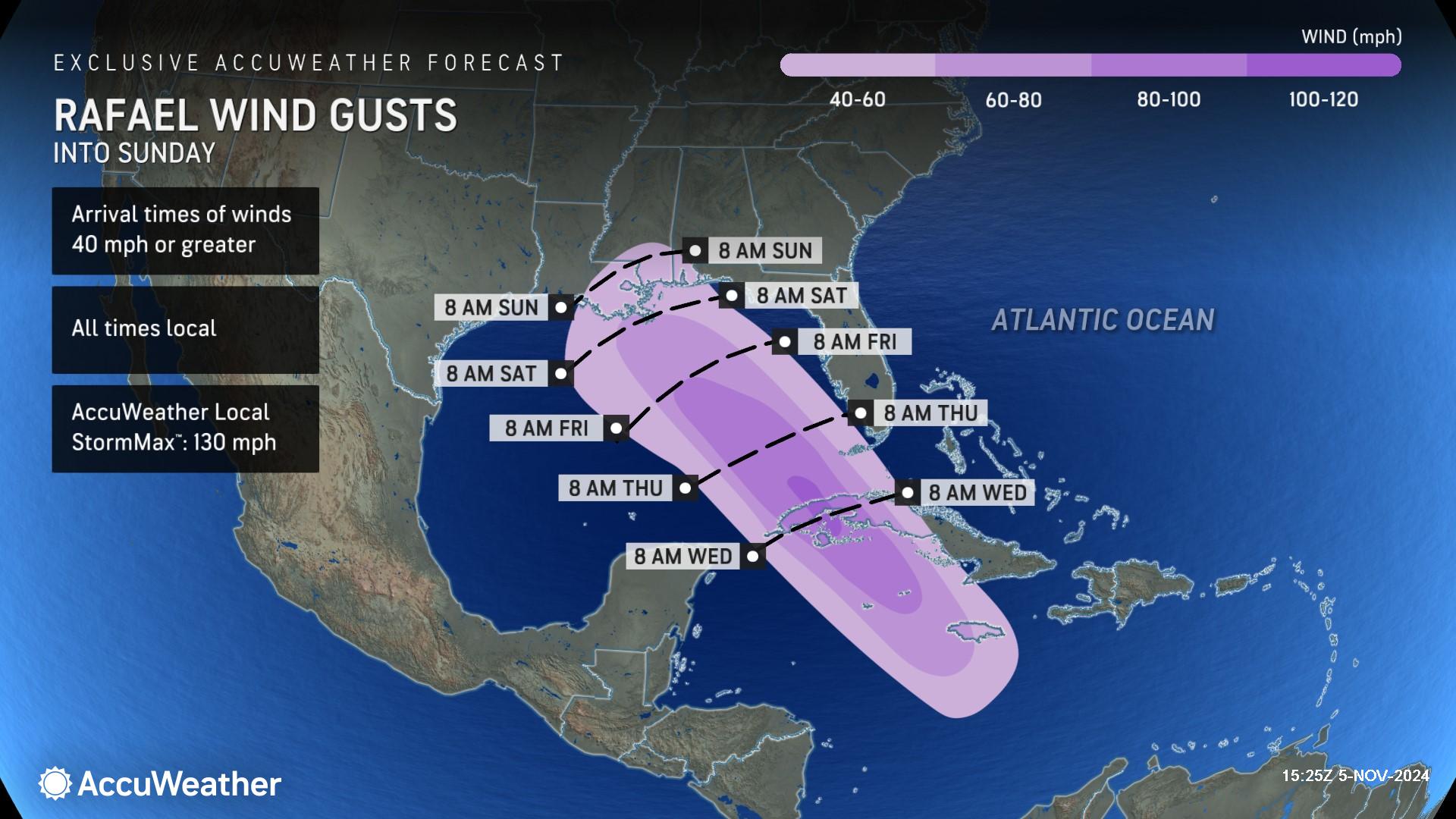
As Rafael moves over the western Caribbean, it will bring strong wind gusts of 40-60 mph from Jamaica through central and western Cuba. A small area near where the storm makes landfall in Cuba could experience higher gusts of 100-120 mph with an AccuWeather Local StormMax™ of 130 mph. These winds can bring down trees and power lines and cause damage to infrastructure.
Wind gusts during the second half of the week across Florida and the central Gulf Coast will highly depend on the track of the storm and how close it is to the coast. A track closer to the east side of the forecast Eye Path® can bring stronger wind gusts to Florida and the Southeast. In contrast, a track on the western side of the Eye Path® would likely lower the overall risk for damaging wind gusts in the U.S., except for near the point of landfall this coming weekend along the central or western Gulf coast.
AccuWeather hurricane experts say a 1- to 3-foot storm surge is expected along the southern coast of Jamaica through Tuesday and the eastern Cayman Islands and portions of southern Cuba through Wednesday. A 6- to 10-foot storm surge can be expected near where the storm makes landfall in western Cuba with an AccuWeather Local StormMax™ of 13 feet. A 1- to 3-foot storm surge is then expected along the Florida Keys Wednesday into Thursday.
Gulf Coast on Alert
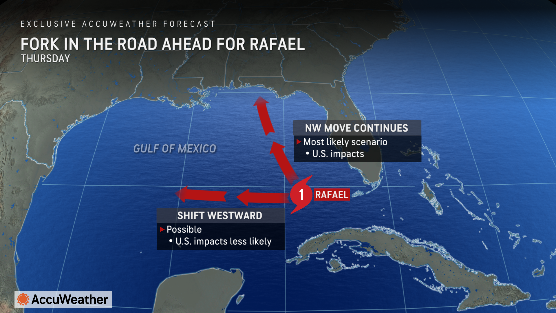
AccuWeather hurricane experts say the highest probability of a United States landfall is along the eastern Louisiana coast. However, since steering winds may change a bit late this week and this weekend due to the approach of a non-tropical storm from the south-central U.S., there is a wide window as to where landfall could occur. That landfall potential zone extends from the Florida Panhandle to the upper Texas coast.
Other scenarios take a much weaker tropical storm much farther to the west toward Mexico versus the U.S. In this case, impacts on the U.S. could be minimal, and Rafael could succumb to wind shear.
In yet another scenario, Rafael could lose so much wind intensity that it arrives in the U.S. as a tropical depression or tropical wind and rainstorm.
In a worst-case scenario, a combination of Rafael rapidly intensifying and taking a track along the eastern side of the Eye Path® forecast cone could lead to life-threatening impacts in the form of flooding rain, damaging winds, and dangerous storm surges in areas of Florida that were impacted by hurricanes Helene and Milton.
“Rafael is going to encounter a fork in the road on Thursday. Once the storm passes over Cuba and reaches the Gulf of Mexico, it will either track to the west or be drawn to the north. A westward track would greatly reduce the risk of U.S. impacts,” Poter explained. “If Rafael continues moving to the northwest, we could see a landfall between Louisiana to Florida.”
AccuWeather hurricane experts say the impacts from Rafael, combined with another non-tropical storm, could spread a zone of drenching rain and locally severe thunderstorms over parts of the interior South Central and Southeastern states as it moves inland.
Heavy rainfall is forecast to precede any direct rain from Rafael and may prime the dry landscape enough to trigger flooding more easily than if Rafael were to move over the region by itself.
A similar yet more extreme condition was present during Helene. In the case of pre-Rafael impacts, the heaviest rain is likely to fall on coastal areas of Georgia and South Carolina rather than the southern Appalachians. Heavy rain fell on the southern Appalachians rather than the coast before Helene.
In the case of the recent flash flood disaster during Helene in the southern Appalachians, intense rain fell in a matter of hours just before Helene's arrival. In the current situation, the widespread dry ground may be able to absorb a significant amount of rain that falls at midweek, where that rain is spread out over a couple of days rather than a few hours. There is also a longer gap in between both rain events this time, compared to Helene.
AccuWeather hurricane experts say enough rain could fall on the southern Appalachians and parts of the Southeastern states to cause flooding and other issues. Even though the ground has become dry in recent weeks after Helene, it may not take as much rain to trigger flooding issues in the region, especially where drainage infrastructure and roads have not been fully repaired since Helene. A damaged tree canopy may also lead to greater and faster runoff in some instances.
While the magnitude of flooding that occurred over the southern Appalachians from Helene is not currently expected to occur in the same area with Rafael, any location where rain concentrates and falls at a heavy rate for multiple hours could be at risk for significant urban flooding and flooding along small streams.
Aside from the risk of flash flooding, the storm may bring much-needed rain and relief to areas dealing with brush fires and wildfires this weekend and next week. Impacts from the combination of storms may bring the first soaking rain in months to parts of the Central and Eastern states.
AccuWeather was the first known source to issue a track and impacts forecast Saturday, a day in advance of the National Hurricane Center.
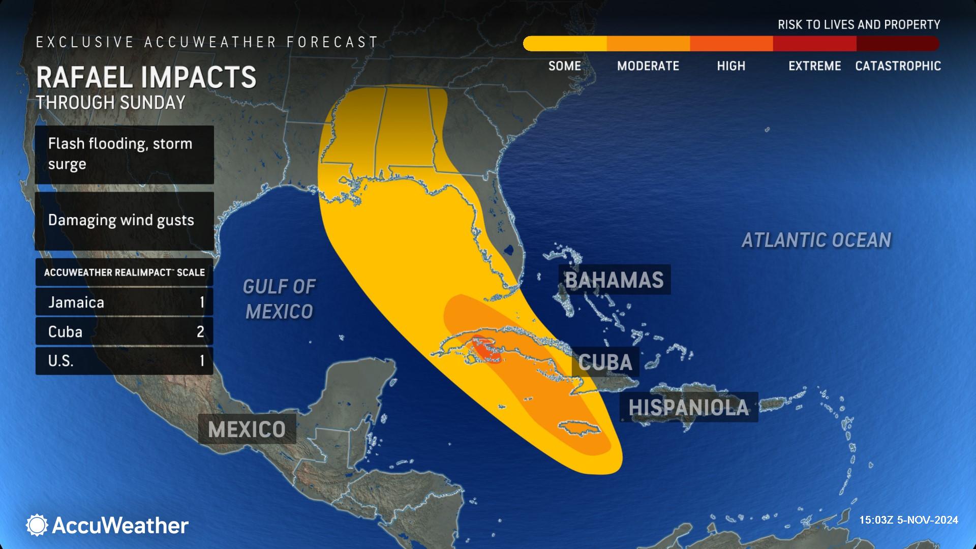
Due to the rain and wind, the AccuWeather RealImpact™ Scale for Hurricanes is a 1 for Jamaica and the United States.
A 1 on the AccuWeather RealImpact™ Scale for Hurricanes warns of localized flooding, damage to unanchored mobile homes, tree damage, localized power outages and coastal inundation resulting in some property damage.
Rafael is a 2 on the AccuWeather RealImpact™ Scale for Hurricanes for Cuba, which warns of moderate flooding, significant wind damage to small buildings, mobile homes and trees, as well as power outages and significant property damage from coastal inundation.
In contrast to the Saffir-Simpson Hurricane Wind Scale, which classifies storms by wind speed only, the AccuWeather RealImpact™ Scale is based on a broad range of important factors. In order to better communicate a more comprehensive representation of the potential impact of a storm on lives and livelihoods, the scale covers not only wind speed, but also flooding rain, storm surge and economic damage and loss. Some of these hazards, such as inland flooding and storm surge in many storms, result in more deaths and economic loss than wind.
AccuWeather Forecast Graphics
Additional AccuWeather Resources:
Tropical storm likely to brew in Caribbean, may reach US
Severe storms, flooding to impact central US through Election Day


