AccuWeather meteorologists are available 24/7 to provide further insights and updates on evolving weather conditions. Please contact pr@accuweather.com during regular business hours, or support@accuweather.com or call AccuWeather’s Media Hotline at (814)-235-8710 at any time to arrange interviews with AccuWeather experts or to request the most updated graphics for print or broadcast.
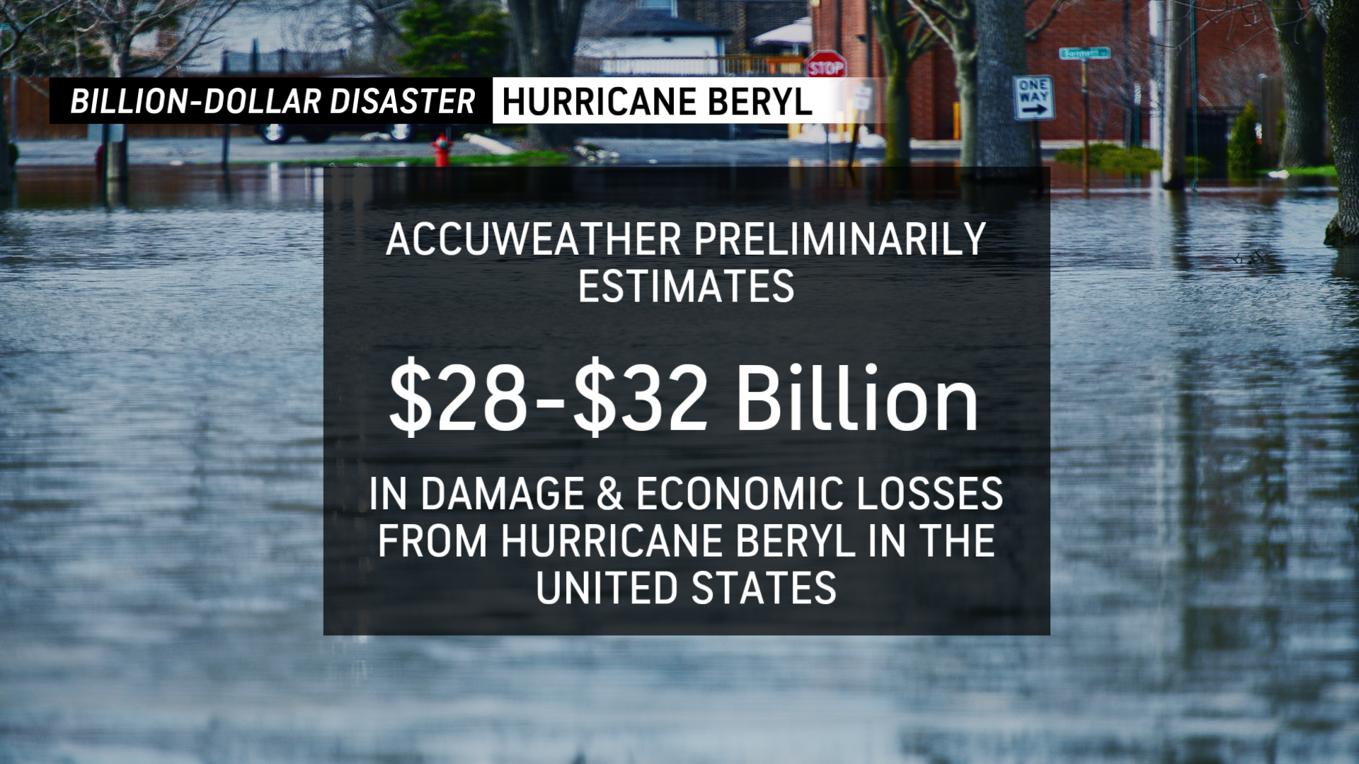
AccuWeather’s Preliminary Estimate of the Total Damage and Economic Loss from Hurricane Beryl in the United States is $28-32 Billion
July 9, 2024
Hurricane Beryl brought damaging storm surge to the coast near and east of where the center made landfall, and destructive winds and widespread flooding rain through central and eastern Texas and Arkansas, as well as several destructive tornadoes. Beryl, now a tropical rainstorm, will continue to produce a variety of life-threatening dangers over the coming days. The storm will move northeastward through the Midwest and then Northeast and will bring the risk for heavy rainfall and flooding from Illinois and Indiana northeastward to northern and central New England over the next couple of days as well as severe thunderstorms east of its track.
AccuWeather Global Weather Center – July 9, 2024

AccuWeather exclusively issued the first forecast of the storm more than 24 hours before any other source, giving valuable additional life-saving notice to those in the eastern Caribbean Islands, and AccuWeather also indicated that Beryl would become a major hurricane ahead of any other source. Beryl went on to impact these islands as a major Category 4 hurricane on the Saffir-Simpson Hurricane Wind Scale with maximum sustained winds of 140 mph, resulting in major damage. It then made its way, as accurately forecast by AccuWeather ahead of other known sources, through the Caribbean with heavy impacts on Jamaica and then the Yucatan Peninsula before turning northwestward to the central Texas coast. As a Category 1 hurricane, Beryl brought a damaging storm surge of 6-10 feet to areas near and just east of landfall, as well as winds of hurricane force (74 mph or greater) as far north as the Houston Metro.
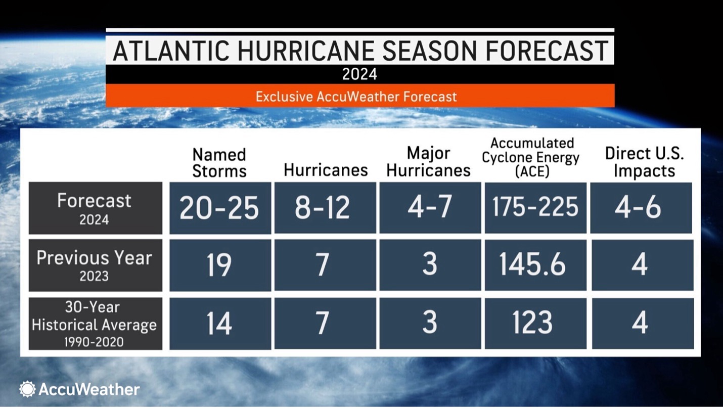
“Beryl will go down in the history books as a record-shattering hurricane. It was the earliest Category 5 hurricane on record in the Atlantic basin, causing catastrophic damage in the Windward Islands. Beryl brought impacts to Jamaica and the Cayman Islands before slamming into the Yucatan Peninsula of Mexico with damaging wind and storm surge,” said AccuWeather Chief Meteorologist Jon Porter. “Very warm waters helped Beryl intensify in its final hours over the Gulf of Mexico before it made landfall in southeast Texas, amplifying the damage and impacts. Millions of people were left without power in scorching summer heat. Several people were tragically killed in flood waters and by falling trees. This was a devastating storm early on, in what is expected to be a very busy and impactful hurricane season for the United States.”
The Houston area was particularly hard hit once again following the destructive thunderstorm windstorm in May. This time, 8-12 inches of rain combined with these winds, leading to widespread flooding and wind damage, with more than 2 million homes and businesses losing power. Extensive cleanup will be required with numerous trees and power lines downed and many streets flooded. Some homes and businesses sustained damage from the high winds with many cases of trees falling on structures resulting in significant damage. It could take several days or even a week or more to get the power restored for the entire area. The summer heat and humidity in Texas, with AccuWeather RealFeel® Temperatures of 100-105 degrees Fahrenheit over the coming days, creates an elevated risk of heat exhaustion or heat stroke for people cleaning up storm debris and repairing damage who do not have access to air conditioning, fans, or cooler shaded areas.
The storm also brought numerous tornadoes and flooding through eastern Texas, into Arkansas and southeastern Missouri, with the storm then moving toward the Midwest and then New England. At this point, flooding rain will become the main threat with the storm, as well as the risk for severe thunderstorms and isolated tornadoes east of the path of the storm.
AccuWeather’s estimate largely accounts for damage to homes, businesses, infrastructure, facilities, roadways and vehicles as well as power outages, which results in food spoilage and interruption to medical care and reflects damage that has already occurred as well as expected damage yet to occur over the coming days as Tropical Rainstorm Beryl moves up through the Midwest, Great Lakes, and to central and northern New England, causing flooding, localized tornadoes, and gusty winds.
AccuWeather’s damage estimate incorporates independent methods to evaluate direct and indirect impacts of the storm, includes both insured and uninsured losses, and is based on a variety of sources, statistics, and unique techniques AccuWeather uses to estimate the damage, to property, job and wage losses, crops, infrastructure damage, interruption of the supply chain, auxiliary business losses and flight delays or cancellations. The estimate also accounts for the costs of evacuations, relocations, emergency management, and the government expenses for cleanup operations. It also includes the long-term effect on business logistics, transportation, tourism as well as the tail health effects and the medical and other expenses of yet unreported deaths and injuries.
To put this event into context, last year Hurricane Idalia, which made landfall into the Big Bend of Florida, caused $18-20 billion in total damage and economic loss. Hurricane Ian, in 2022, caused $180-210 billion. Hurricane Harvey, which impacted a similar area in Texas, caused $230 billion in total damage and economic loss in 2017 when the storm stalled over southeast Texas for days, producing record rainfall amounts which led to catastrophic flooding.


